
Sealdah Railway Station is one of India's major railway terminals serving the city of Kolkata. The other main railway stations in the Kolkata metropolitan area are Howrah, Shalimar, Kolkata and Santragachi. Over 1.5 million passengers use the station daily. It is an important suburban rail terminal. Kolkata Metro Line 2 passes through Sealdah with the new underground Sealdah metro station.
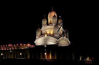
Dakshineswar is a locality in Kolkata Metropolitan Area of North 24 Parganas district under the jurisdiction of Kolkata Metropolitan Development Authority (KMDA). This place is historically famous for Dakshineswar Kali Temple, locally known as Maa Bhabatarini Mandir.

Sodepur or Sodpur is a locality in Panihati Municipality of North 24 Parganas district in the Indian state of West Bengal. It is located in north suburban Kolkata and the area is covered by Kolkata Metropolitan Development Authority (KMDA). Barrackpore, Kamarhati, Dumdum, Agarpara, and Belghoria are all close by. It is a centre for rising residential construction. GM Meena Icon, Peerless Nagar, Merlin Maximus, Godrej Prakriti, and NPR Gitanjali Apartments are a few notable residential developments in the neighbourhood.

Baranagar or Baranagore is a city and a municipality in North Kolkata of the Indian state of West Bengal. It is a part of the area covered by Kolkata Metropolitan Development Authority (KMDA). Baranagar is the fifth most densely populated city proper in the world.

Durganagar is a locality in North Dumdum of North 24 Parganas District in the Indian state of West Bengal. It was named after the goddess Durga. It is a part of area under jurisdiction of Kolkata Metropolitan Development Authority (KMDA). Kolkata Airport is located nearby.
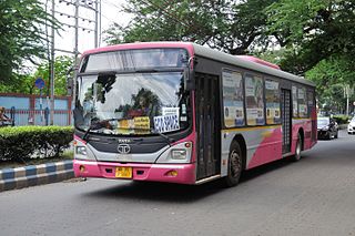
The transport system of Kolkata, a city in India, is a mix of modern mass rapid transport and old transport modalities like rickshaws. Kolkata is connected to the rest of India by the National Highways, the extensive network of the Indian Railways, National Waterways and by air. The most traffic to Northeast India route is via Kolkata.
Belgharia is a locality in Kamarhati Municipality of North 24 Parganas district in the Indian state of West Bengal. It is a part of the area covered by Kolkata Metropolitan Development Authority (KMDA) and a vital locality in Kolkata metropolitan area. Belgharia is also known for wholesale market for all types of bags, luggage, and purses. Dakshineswar Kali Temple of Kolkata is in approximately three kilometers distance from Belgharia Railway Station. The Vivekananda Setu on the river of Hooghly which is one of the oldest bridges in Calcutta established for the connection between the city of Howrah and Kolkata is also at the adjacent area of Belgharia.

Dum Dum is an elevated metro station on the North-South corridor of the Blue Line of Kolkata Metro in Kolkata, West Bengal, India. The metro station adjoins the platforms of the Dum Dum railway station where connections can be made with Indian Railways services.

Barrackpore Trunk Road, commonly known as BT Road, is six-laned trunk road in Kolkata metropolitan area, West Bengal, India. It connects Kolkata with its suburb Barrackpore. Built in 1775, it is the oldest metalled road and one of the busiest roads in the country. The 18.1 km (11.2 mi) long road is a part of both State Highway 1 and State Highway 2.

Dum Dum Junction is a very important and busy junction station of the Kolkata Suburban Railway on the Sealdah–Ranaghat line. Three lines branch out from Dum Dum in the north direction–the Kolkata Eastern line to Gede, the Calcutta chord line to Dankuni and the Sealdah–Hasnabad–Bangaon–Ranaghat line to Bangaon and Hasnabad. On the other hand in the south direction, those three lines go to the Sealdah, while the Kolkata Circular Railway line arises from it towards Patipukur, and also ends to it through Bidhannagar Road after encircling the city of Kolkata through various important stations like Kolkata railway station and Majerhat.

Barrackpore is a major railway station in North 24 Parganas district in the Indian state of West Bengal, which serves the city of Barrackpore. It lies on the Sealdah–Ranaghat line and is part of the Kolkata Suburban Railway system and is under the jurisdiction of Eastern Railway.

Birati railway station is a Kolkata Suburban Railway station in Birati. It serves the local areas of Birati and Nimta in North 24 Parganas district, West Bengal, India. It lies between the Durganagar railway station and the Bisharpara Kodaliya railway station. Madhusudan Banerjee Road connects the Barrackpore Trunk Road and Jessore Road through Birati.
Nimta is a locality in North Dumdum Municipality of North 24 Parganas district in the Indian state of West Bengal. It is a part of the area covered by Kolkata Metropolitan Development Authority (KMDA).
Belgharia railway station or Belghoria railway station is a Kolkata Suburban Railway and one of the oldest railway stations in India. It is located in Belgharia, North 24 Parganas district, West Bengal, India. This railway station situates between the Agarpara railway station and the Dum Dum Junction railway station.

Baranagar, also known as JSW Baranagar is an elevated metro station on the North-South corridor of the Blue Line of Kolkata Metro which is off Barrackpore Trunk Road at Dunlop of Baranagar in Kolkata, West Bengal, India. Presently, this metro station is the tallest metro station of Kolkata. The metro station adjoins the platforms of the Baranagar Road railway station where connections can be made with Indian Railways services. The station was inaugurated on 22 February 2021.

Dakshineswar is a railway station of Eastern Railway. It is 13 km away from Sealdah and 9 km from Dankuni Junction on the Sealdah–Dankuni line of Eastern Railway. Dankuni and Bardhaman local train connects this place to Sealdah Station and other stations of the Sealdah main line. It is an important railway station between Dum Dum and Dankuni railway stations.

Bally Ghat railway station is a station of Eastern Railway in Howrah. It is 15 km away from Sealdah and 7 km from Dankuni Junction on the Sealdah–Dankuni line of Eastern Railway. It is part of the Kolkata Suburban Railway system. Dankuni and Bardhaman local trains connect this place to Sealdah Station and other stations of the Sealdah main line. It is an important railway station between Dum Dum and Dankuni.

Bally Halt railway station is a station of Eastern Railway in Howrah. It is 16 km away from Sealdah and 6 km from Dankuni Junction on the Sealdah–Dankuni line of Eastern Railway. It is part of the Kolkata Suburban Railway system. Dankuni and Bardhaman local train connects this place to Sealdah Station and other stations of the Sealdah main line. It is an important railway station between Dum Dum and Dankuni railway stations. It is located directly above the Bally railway station on the Howrah–Barddhaman main line and Howrah–Bardhaman chord lines, making it an important railway transportation hub.

Rajchandrapur railway station is a station of Eastern Railway. It is 17 km away from Sealdah and 5 km from Dankuni Junction on the Sealdah–Dankuni line of Eastern Railway. It is a part of the Kolkata Suburban Railway system. Dankuni and Bardhaman local train connects this place to Sealdah Station and other stations of the Sealdah main line. It is an important railway station between Dum Dum and Dankuni railway stations.

Dunlop is a neighbourhood in Baranagar of North Kolkata in the Indian state of West Bengal. It is under the jurisdiction of Kolkata Metropolitan Development Authority (KMDA) and Barrackpore Police Commissionerate.


