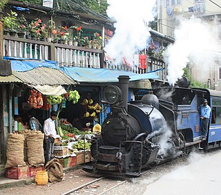
The Darjeeling Himalayan Railway, also known as the DHR or the Toy Train, is a 610 mm gauge railway that runs between New Jalpaiguri and Darjeeling in the Indian state of West Bengal. Built between 1879 and 1881, it is about 88 km (55 mi) long. It climbs from about 100 m (330 ft) above sea level at New Jalpaiguri to about 2,200 m (7,200 ft) at Darjeeling, using six zig zags and three loops to gain altitude. Ghum station is situated at an altitude of 2,258 metres (7,407 ft). Six diesel locomotives handle most of the scheduled service, with daily tourist trains from Darjeeling to Ghum – India's highest railway station – and the steam-hauled Red Panda service from Darjeeling to Kurseong. Steam-enthusiast specials are hauled by vintage British-built B-Class steam locomotives. The railway's headquarters are at Kurseong.

The Northeast Frontier Railway is one of the 19 railway zones of the Indian Railways. It is headquartered in Maligaon, Guwahati in the state of Assam, and responsible for operation and expansion of rail network all across Northeastern states and some districts of eastern Bihar and northern West Bengal.

New Jalpaiguri Junction railway station established in 1960, is an A1 category broad-gauge and narrow-gauge railway station under Katihar railway division of Northeast Frontier Railway zone. It is the largest and the busiest railway junction of northern Bengal. This junction is largest among the railway stations which serve the city of Siliguri, the largest metropolis of the North Bengal. The other stations are- Siliguri Junction, Gulma, Bagdogra, Matigara, Rangapani and Siliguri Town. New Jalpaiguri junction ranked 10th cleanest railway station in India in 2016 survey and came among the top 100 booking stations of Indian railway. New Jalpaiguri, as a railway station serves as the entry point to North Bengal, Sikkim, other countries like Nepal, Bhutan, Bangladesh and the seven northeastern states. New Jalpaiguri Junction acts as a connecting base of railways for the northeastern states to the Indian mainland.
The Mountain railways of India are the railway lines that were built in the mountainous regions of India. The term mainly includes the narrow-gauge railways in these regions but may also include some broad-gauge railways.

Kurseong is a town and a municipality in Darjeeling district in the Indian state of West Bengal. It is the headquarters of the Kurseong subdivision.

Darjeeling Sadar subdivision is a subdivision of the Darjeeling district in the state of West Bengal, India.

Ghum is a small hilly neighbourhood in the Darjeeling Himalayan hill region of West Bengal, India. It comes under ward number one of the Darjeeling Municipality. Ghum railway station of the Darjeeling Himalayan Railway is the highest railway station in India. It is situated at an altitude of 2,258 metres (7,407 ft). The place is the home of the Ghum Monastery and the Batasia Loop, a bend of the Darjeeling Himalayan Railway.
Transport in Darjeeling consists of the intra-city transport and the communication between the city and other locations in Darjeeling district. Darjeeling is a hill station in the Indian state of West Bengal and it is the headquarters of Darjeeling district situated in the Mahabharat Range at an average elevation of 2,134 m above sea level.

Maney Bhanjyang is a small transit-town in the Darjeeling Sadar subdivision, Darjeeling district in the state of West Bengal in India. It is located at the gateway of the Singalila National Park, 28 km away from Darjeeling town. The income of the local residents is geared towards tourism, especially foreign trekkers. Maney Bhanjyang is the start of the trailhead for the trek to Sandakphu on the Singalila Ridge, the highest point in West Bengal. Conveyance for Sandakphu is also available mainly from Maney Bhanjyang in the form of Land Rovers of 1960 model. The 4-hour ride can be quite 'jumpy' as drivers maneuver their prized possessions along snaky curves and uphill roads.

Tindharia or Tindharay is a village in the Kurseong CD block in the Kurseong subdivision of the Darjeeling district in the state of West Bengal, India.

Sonada is a census town in the Jorebunglow Sukhiapokhri CD block in the Darjeeling Sadar subdivision of the Darjeeling District in West Bengal, India.
Jorebunglow Sukhiapokhri is a community development block that forms an administrative division in the Darjeeling Sadar subdivision of the Darjeeling district in the Indian state of West Bengal.

Kurseong is a community development block that forms an administrative division in the Kurseong subdivision of the Darjeeling district in the Indian state of West Bengal.

Siliguri Junction is one of the major and second largest railway station that serve the city of Siliguri located in Darjeeling district in the Indian state of West Bengal. The station has two types of gauges visible i.e. 1,676 mm broad gauge, & 610 mm narrow-gauge tracks for Darjeeling Himalayan Railway. It was opened in 1949. It formerly had the distinction of having three gauges visible but the metre-gauge line from Aluabari Road to Siliguri Junction was converted later into broad gauge. A few years ago, the trains used to run between Siliguri Junction to Naksalbari on the metre-gauge line. Siliguri Junction lies on three railway lines New Jalpaiguri–Alipurduar–Samuktala Road line, Katihar–Siliguri line and Darjeeling Himalayan Railway Line. This railway station also has its own locomotive shed i.e Diesel Loco Shed, Siliguri

Ghum railway station of the Darjeeling Himalayan Railway is situated at an altitude of 2,258 metres (7,407 ft). The place is the home of the Ghum Monastery and the Batasia Loop, a bend of the Darjeeling Himalayan Railway.

The DHR B Class is a class of 2 ft gauge 0-4-0ST saddle tank steam locomotives used on the Darjeeling Himalayan Railway (DHR) in West Bengal, India.
The Beeches Light Railway was a private narrow gauge railway in Steeple Aston, Oxfordshire, England, in the garden of Adrian Shooter. The line contained one station, Rinkingpong Road at an elevation of 351 feet (107 m) above sea level.
Gayabari is a tea garden village in the Kurseong CD block in the Kurseong subdivision of the Darjeeling District of West Bengal state, India.

Sukna is a village and a gram panchayat in the Kurseong CD block in the Kurseong subdivision of the Darjeeling district in the state of West Bengal, India.


