Noapara metro station and depot

Last updated

Noapara

নোয়াপাড়া
Kolkata Metro station (interchange and terminus)
INSIDENOAPARACAL.jpg
Inside Noapara interchange metro station.
General information
LocationAkshay Kumar Mukherjee Road, Noapara, Baranagar
Coordinates 22°38′23″N88°23′38″E / 22.639673°N 88.393978°E / 22.639673; 88.393978
Owned by Metro Railway, Kolkata
Kolkata Metro Rail Corporation
Operated by Kolkata Metro
Line(s) Blue Line Yellow Line
Platforms1 Island and 2 Side platform
Platform-1 → Dakshineswar
Platform-2 → Kavi Subhash
Tracks4 (2 more tracks lead to the depot)
Construction
Structure type Elevated, Double track
AccessibleYes Wheelchair symbol.svg
Other information
StatusStaffed, Operational
Station codeKNAP
Fare zoneKOAA
History
Opened10 July 2013;10 years ago (2013-07-10)
Services
Preceding station Kolkata Metro Logo.svg Kolkata Metro Following station
Baranagar
towards Dakshineswar
Blue Line Dum Dum
towards Kavi Subhash
Terminus Yellow Line
(under construction)
Dum Dum Cantonment
towards Barasat
Location
Noapara metro station and depot
Noapara metro station OUTSIDENOAPARACAL.jpg
Noapara metro station

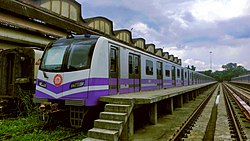
Noapara is the largest elevated metro station on the North-South corridor of the Blue Line of Kolkata Metro in Noapara, Baranagar, Kolkata, West Bengal, India. [1] It opened on 10 July 2013. [2]

Contents

Station

This interchange station includes two side and an island platform with lengths of 182 meters, unlike other Kolkata Metro stations. [3] It serves the localities of Noapara, Tobin Road and Bonhooghly. The station has 2 stories, with 6 escalators and 4 elevators. There are also 31 CCTV cameras for increased security. [4] The Kolkata Metro owns a 147-acre depot for maintenance and storage of rakes immediate east of the station. [5] This elevated metro station for the serves both Blue Line and Yellow Line under Kolkata Metro, the latter being sought to be opened on 14 April 2024. [6]

Layout

  Line 1    Line 4  

Noapara track layout
BSicon vCONTgfa.svg
BSicon cPLT.svg
BSicon vSTR.svg
BSicon cPLT.svg
P1
BSicon cPLT.svg
BSicon vSTR.svg
BSicon cPLT.svg
P2
BSicon cPLT.svg
BSicon vSTR.svg
BSicon cPLT.svg
BSicon vCONTgfe.svg
Station with two tracks and two side platforms
GStreet levelExit/Entrance
L1MezzanineFare control, station agent, Metro Card vending machines, crossover
L1 Side platform | Doors will open on the left Wheelchair symbol.svg
Yellow Line Station Layout & Platform Numbers - (TBC)
Platform #
Northbound
Towards → Barasat next station is Dum Dum Cantonment
Platform #
Southbound
Towards ← Train Terminates Here
Island platform | P# & P2 doors will open on the left Wheelchair symbol.svg
Platform 2
Southbound
Towards → Kavi Subhash next station is Dum Dum
Platform 1
Northbound
Towards ← Dakshineshwar next station is Baranagar
Side platform | Doors will open on the left Wheelchair symbol.svg
L2

Depot

Map of Noapara depot, Kolkata Noapara depot map.svg
Map of Noapara depot, Kolkata

This is the oldest and biggest metro depot in India. It serves the Kolkata Metro Line 1 and will also serve Kolkata Metro Line 4 in future. This depot can hold maximum 40 rakes at a time. Newly received rakes are also tested here, and the old ones are kept here. The depot is connected to the Kolkata Chord line, so that newly manufactured rakes can directly be brought via train.

History

It was opened in 1984. Before that, it was a Railway yard and a track extended till Texmaco Rail & Engineering manufacturing unit.

Connections

Bus

Bus route number 34C serves the station. [7]

Auto

Noapara Metro to Bonhoogly and Pramod Nagar to Tobin Road.

See also

Related Research Articles

<span class="mw-page-title-main">Kolkata Metro</span> Rapid transit system in Kolkata, India

The Kolkata Metro is a rapid transit system serving the city of Kolkata and the wider Kolkata Metropolitan Region in West Bengal, India. Opening in 1984, it was the first operational rapid transit system in India, beside being the second busiest and fourth-longest metro network in India. As of March 2024, it has four operational lines: the 32.33 km (20.09 mi) Line 1 from Dakshineswar to Kavi Subhash, 13.9 km (8.6 mi) Line 2 from Salt Lake Sector V to Howrah Maidan, 7.75 km (4.82 mi) Line 3 from Joka to Majerhat and 5.4 km (3.4 mi) Line 6 from Kavi Subhash to Hemanta Mukherjee for a total of 59.38 km (36.90 mi). Two other lines are in various phases of construction and planning. The system has a mix of underground, at-grade and elevated stations using both broad-gauge and standard-gauge tracks. Trains operate between 06:55 and 22:30 IST and the fares range from ₹5 to ₹50.

<span class="mw-page-title-main">Dakshineswar</span> Neighbourhood in North 24 Parganas, West Bengal, India

Dakshineswar is a locality in Kolkata Metropolitan Area of North 24 Parganas district under the jurisdiction of Kolkata Metropolitan Development Authority (KMDA). This place is historically famous for Dakshineswar Kali Temple, locally known as Maa Bhabatarini Mandir.

<span class="mw-page-title-main">North 24 Parganas district</span> District in West Bengal, India

North 24 Parganas (abv. 24 PGS (N)) or sometimes North Twenty Four Parganas is a district in southern West Bengal, of eastern India. North 24 Parganas extends in the tropical zone from latitude 22° 11′ 6″ north to 23° 15′ 2″ north and from longitude 88º20' east to 89º5' east. Barasat is the district headquarters of North 24 Parganas. North 24 Parganas is West Bengal's most populous district and also (since 2014) the most populated district in the whole of India. It is the tenth-largest district in the State by area.

<span class="mw-page-title-main">Baranagar</span> City in West Bengal, India

Baranagar or Baranagore is a city and a municipality in Kolkata Metropolitan Area of North 24 Parganas district in the Indian state of West Bengal. It is a part of the area covered by Kolkata Metropolitan Development Authority (KMDA). Baranagar is the fifth most densely populated city proper in the world.

<span class="mw-page-title-main">Transport in Kolkata</span>

The transport system of Kolkata, a city in India, is a mix of modern mass rapid transport and old transport modalities like rickshaws. Kolkata is connected to the rest of India by the National Highways, the extensive network of the Indian Railways, National Waterways and by air. The most traffic to Northeast India route is via Kolkata.

<span class="mw-page-title-main">Belgharia</span> Neighbourhood in West Bengal, India

Belgharia is a locality in Kamarhati Municipality of North 24 Parganas district in the Indian state of West Bengal. It is a part of the area covered by Kolkata Metropolitan Development Authority (KMDA) and a vital locality in Kolkata metropolitan area. Belgharia is also known for wholesale market for all types of bags, luggage, and purses. Dakshineswar Kali Temple of Kolkata is in approximately three kilometers distance from Belgharia Railway Station. The Vivekananda Setu on the river of Hooghly which is one of the oldest bridges in Calcutta established for the connection between the city of Howrah and Kolkata is also at the adjacent area of Belgharia.

The rolling stock of Kolkata Metro, India consists of five classes, three classes for Line 1 and two classes for Line 2.

<span class="mw-page-title-main">Urban rail transit in India</span> Overview of the urban rail transit system in India

Urban rail transit in India plays an important role in intracity transportation in the major cities which are highly populated. It consists of rapid transit, suburban rail, monorail, and tram systems.

<span class="mw-page-title-main">Netaji metro station</span> Kolkata Metros Blue Line metro station

Netaji is an elevated metro station on the North-South corridor of the Blue Line of Kolkata Metro in Kolkata, West Bengal, India. This station is situated opposite to the Kudghat bus stand at Kudghat, in Tollygunge.

<span class="mw-page-title-main">Kolkata Metro Line 1</span> Transit line of rapid transport in Kolkata, India

The Line 1, Blue Line, also known as North–South Metro of the Kolkata Metro, is a rapid transit system serving Kolkata in Indian state of West Bengal. It consists of 26 operational stations from Dakshineswar to Kavi Subhash. Nine of the stations are elevated, 2 at-grade and the remaining 15 are underground, with a total distance of 32.13 km (19.96 mi). The line connects Dakshineswar and New Garia and uses 5 ft 6 in broad gauge rolling stock. Dakshineswar was opened on 22 February 2021 is an elevated station located 4.1 km (2.5 mi) north of Noapara. It was the first underground railway to be built in India, with the first operations commencing in October 1984 and the full stretch that was initially planned being operational by February 1995. On 28 December 2010, it became the 17th zone of the Indian Railways. Being the country's first, and a completely indigenous process, the construction of the Kolkata Metro was more of a trial-and-error affair, in contrast to the Delhi Metro, which has seen the involvement of numerous international consultants. As a result, it took nearly 23 years to completely construct around 15 km (9.3 mi) underground railway from Birpara up to Tollygunge Metro Station.

<span class="mw-page-title-main">Kolkata Metro Line 2</span> Transit line in Kolkata, India

Kolkata Metro Line 2, also known as the East-West Metro and Green Line, is a rapid transit line of the Kolkata Metro in the Indian state of West Bengal. It currently consists of two distinctly operational sections between Salt Lake and Sealdah, and Esplanade and Howrah Maidan by going underneath the Hooghly River, with an eastern extension planned for Teghoria. It will cover a distance of 32.11 km (19.95 mi) and consist of 17 stations from Teghoria (Haldiram) in the east to Howrah Maidan in the west, of which it will consist of 11 elevated and 6 underground stations, and the operational section consists of 6 elevated and 5 underground stations, with a total distance of 22 km (14 mi). It is expected to derive a very high ridership, since it will connect India's two largest commuter railway and long-distance railway terminals, Howrah and Sealdah, along with two of its largest business districts, BBD Bagh and Salt Lake Sector V. At present, more than 100,000 passengers commute through the line every day, and this figure is expected to go up to 1 million after it gets fully completed by 2035. It will also connect the industrial hub of Kolkata, i.e., Howrah and the IT hub of Kolkata, i.e., Salt Lake Sector-V. It connects Line 1 at Esplanade and will eventually connect Lines 3 and 6.

<span class="mw-page-title-main">Noapara, Baranagar</span> Neighbourhood in Baranagar of North 24 Parganas district, West Bengal, India

Noapara is a locality in Baranagar of North 24 Parganas district in the Indian state of West Bengal. It is a part of the area covered by Kolkata Metropolitan Development Authority (KMDA).

<span class="mw-page-title-main">Kolkata Metro Line 3</span> Transit line in Kolkata, India

Kolkata Metro Line 3 or the Purple Line is a line of the Kolkata Metro. The 6.5 kilometres (4.0 mi) stretch from Joka to Taratala of the 15.08 kilometres (9.37 mi) line was inaugurated on 30 December 2022 before being extended to Majerhat on 6 March 2024. The route will span 15.08 kilometres (9.37 mi) from Joka in the south, to Esplanade in the north with a future extension of 3.39 kilometres (2.11 mi) to Diamond Park from Joka. It will connect Kolkata Metro Line 1 at Park Street in central Kolkata and run in parallel up to Esplanade in central Kolkata where it will connect Kolkata Metro Line 2 also. Line 3 is being built by Rail Vikas Nigam Limited.

<span class="mw-page-title-main">Kolkata Metro Line 4</span> Transit line in Kolkata, India

The Kolkata Metro Line 4 or the Yellow Line, also known as the Noapara - Barasat Line of the Kolkata Metro in India is a 16.876 km (10.486 mi) long metro route from Noapara to Barasat in North 24 Parganas, which is under construction. It is being built by RVNL, Senbo & ITD. It will run mostly underground viaducts. The track will be elevated until Jessore Road Station and then go underground towards Barasat metro station. It will have an interchange station at the NSCBI Airport with Kolkata Metro Line 6.

<span class="mw-page-title-main">Dakshineswar metro station</span> Kolkata Metros Blue Line terminal metro station

Dakshineswar is the elevated northern terminal metro station on the North-South corridor of the Blue Line of Kolkata Metro in Kolkata, West Bengal, India. The metro station adjoins the platforms of the Dakshineswar railway station where connections can be made with Indian Railways services. The station is located at the Dakshineswar area which is famous for Dakshineswar Kali Temple.

<span class="mw-page-title-main">Jai Hind metro station</span> Kolkata Metro station

Jai Hind is a metro station of Kolkata Metro. It will serve the city's main airport, the Netaji Subhas Chandra Bose International Airport.

<span class="mw-page-title-main">Dum Dum Cantonment metro station</span> Metro station in Kolkata, India

Dum Dum Cantonment is an elevated metro station of line 4 of Kolkata Metro. It is situated just beside the Dum Dum Cantonment railway station. This station was proposed in Line 4, in the budget of 2010–11. It is also the part of the integration of old line of Circular Railway from Dum Dum Cantonment to Jai Hind.

<span class="mw-page-title-main">Baranagar metro station</span> Kolkata Metros Blue Line metro station

Baranagar, also known as JSW Baranagar is an elevated metro station on the North-South corridor of the Blue Line of Kolkata Metro which is off Barrackpore Trunk Road at Dunlop of Baranagar in Kolkata, West Bengal, India. Presently, this metro station is the tallest metro station of Kolkata. The metro station adjoins the platforms of the Baranagar Road railway station where connections can be made with Indian Railways services. The station was inaugurated on 22 February 2021.

<span class="mw-page-title-main">Dunlop, Kolkata</span> Neighbourhood in Baranagar of West Bengal, India

Dunlop is a neighbourhood in Baranagar of North 24 Parganas district, in the Indian state of West Bengal. It is under the jurisdiction of Kolkata Metropolitan Development Authority (KMDA) and Barrackpore Police Commissionerate.

References

  1. Gupta, Jayanta (21 November 2012). "March 2013 date for Noapara Metro". The Times of India . Archived from the original on 4 September 2013. Retrieved 30 May 2013.
  2. "Milestone". mtp.indianrailways.gov.in. Retrieved 17 May 2020.
  3. Gupta, Jayanta (25 May 2013). "Noapara metro opening expected by month's end". The Times of India . Archived from the original on 17 December 2013. Retrieved 30 May 2013.
  4. Banerjee, Tamaghna (11 March 2013). "Noapara Metro from April". The Telegraph. Archived from the original on 30 June 2013. Retrieved 30 May 2013.
  5. Chakroborty, Ajanta (25 December 2012). "From April, fly to Naoapara from Garia in 54 mins flat". The Times of India . Archived from the original on 17 December 2013. Retrieved 30 May 2013.
  6. "Poila Baisakh date for service start on Noapara-Cantonment stretch". The Times of India. 27 March 2024. ISSN   0971-8257 . Retrieved 27 March 2024.
  7. "Bus Services".