Dalkhola was originally in the state of Bihar in India. After 1959, Dalkhola was located in the state of West Bengal. The town expanded around the Dalkhola village panchayats and developed into an important centre for trade and commerce due to mainstream connection with both railway and roadway. It is an important center for commodities like jute, corn and oil trade in North Dinajpur. It is also an important center for the trade of maize, which is produced in the neighboring state of Bihar.[3]
Before, and for some time after, the independence of India in 1947, Dalkhola was a sleepy, rural area where some Pucca and Kaccha roads were connected. The area was mostly covered by jungle, and only some parts of the town were suitable for living. The residents' main source of income was agriculture and fishery in the Mahananda River. It was ruled by Raja P. C. Lal. After the partition of India, numerous refugees (Hindus) came to Dalkhola from Bangladesh (formerly known as East Pakistan) and started living in surrounding rural areas such as Hatbari, Goalgaon (Madrasa), Goalgaon (west), Shikarpur, Pukurchala, Bhusamoni etc. In 1956 the area was transferred to the territory of West Bengal by the tireless efforts of the then Chief Minister Dr. B. C. Roy. It is an important place in this region, as NH 12 and NH 27 intersect at this place. Small villages are administered by the Panchayat Ministry, and they have gradually developed into busy market zones, which gradually converted into small townships. With the growth of population and economic activities, the people of Dalkhola experienced a massive change – in terms of both socio-economic development and quality of life. As a consequence, Dalkhola Municipality was set up on 1 January 2003 to foster social and economic development.
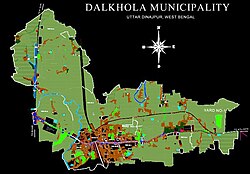
Dalkhola became a municipality in 2003. In the Dalkhola municipal area, there were 14 Wards. But now 2 more ward are divided now there are 16 wards. In last election, the Indian National Congress won 9 seats out of 14, and the Communist Party of India (Marxist) won the other 5 seats.[4] It is one of the four municipalities in North Dinajpur district. Dalkhola has 16 now. in Recently 2013 Municipality election Congress won 10 seats, cpim 4 and Tmc 2. Now whole councillors of congress party joined Trinamool Congress nd now the status are TMC 12, CPIM 4 and CONG 0,
On general civic body election 2022 Dalkhola's figures are 12 Trinamool Congress, 4 Independent
Geography
16km 9.9miles
T
Mahananda River
S
West Bengal
R
Bihar
Q
Bangladesh
P
India
T
Raiganj Wildlife Sanctuary
R
Radhikapur checkpoint
CT
Itahar
CT
Kasba
CT
Nachhratpur Katabari
R
Hemtabad
R
Karandighi
R
Chakulia
R
Goalpokhar
CT
Hanskunda
CT
Chopra
M
Dalkhola
M
Kaliaganj
M
Islampur
M
Raiganj
Cities and towns in the North Dinajpur district M: municipal city/ town, CT: census town, R: rural/ urban centre, T: tourist centre Owing to space constraints in the small map, the actual locations in a larger map may vary slightly
In the map alongside, all places marked on the map are linked in the full screen version.
It is the second-largest area in the Uttar Dinajpur district, with a length 13km from East to West, 18km from North to South. Dalkhola was divided on the 14 wards. But now to more wards are added, 9 number ward divided into 9 and 16 and 11 number ward divided into 11 and 15.
The cooler months in Dalkhola begin in December and end in February. The temperature generally peaks at about 35°C. The annual low temperature is usually near 10°C. The monsoon season starts in June and runs through September.
Dalkhola is the largest exporter of Maize in West Bengal.[citation needed] In Dalkhola, a national level Power Grid was established in 1973, which expanded the availability of electricity to the Municipality and nearby areas of Dalkhola. Other developments include a Flour Mill, Tantia agro chemical Pvt Ltd and maize processing company which use the crops produced by local farmers.[citation needed]
Official languages
As per the West Bengal Official Language (Amendment) Act, 2012, which came into force from December 2012, Bengali was given the status of official language in areas, such as subdivisions and blocks, having more than 50% Bengali speaking population.[7] In North Dinajpur district, Goalpokhar I and II blocks, Islampur block and Islampur municipality were identified as fulfilling the norms set[8] In 2014, Calcutta High Court, in an order, included Dalkhola municipality in the list.[9]
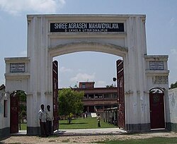
Shree Agrasen Mahavidyalaya was established in 1995. Affiliated to the University of Gour Banga it offers honours courses in Bengali, Hindi, English, history, political science, sociology and accountancy, and general courses in arts and commerce. Urdu is taught as a general subject.[10][11]
Demographics
Religions in Dalkhola Town (2011)
Hinduism (58.3%)
Islam (39.5%)
Others (2.20%)
As per the 2011 Census of India, Dalkhola had a total population of 36,930, of which 19,230 (52%) were males and 17,700 (48%) were females. Population below 6 years was 5,592. The total number of literates in Dalkhola was 21,207 (67.67% of the population over 6 years).[12]
In the 2001 India census, Dalkhola had a population of 13,891. In 2008, the population grew to approximately 19,000. Males constituted 54% of the population and females 46%. The literacy rate in Dalkhola of 69% was greater than the national average of 59.5%; male literacy was 70% and female literacy was 63%. In Dalkhola, 18% of the population was under 6 years of age.
Decadal growth for the period 1991 to 2001 was 30.41% in Dalkhola, compared to 28.72% in the North Dinajpur district.[14] Decadal growth in West Bengal was 17.84%.[15]
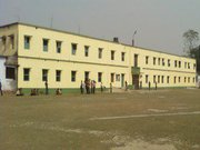
Year of Establishment Dalkhola Municipality has been formed on 01 /01 /2003 as per Notification No. 1 /MA/0 /C-4 /1 M-14 / 2000 with the entire area of Dalkhola 1 and four mouza of Dalkhola 2gram panchayats with a population of 29783 according to the census of 2001. Dalkhola Municipality is the 4 th Municipality of North Dinajpur district constituted with 14 wards and first election was held on 22 /06 /2003 and second election was held on 29 /06 /2008. Sri Himadri Mukharjee was the first chairman and Sri Subhas Goshwami has become the chairman in the second. Sri Tanay Day was the 3 rd chairman. Swadesh sarkar is on chair.[16]
Transport
NH 34 starts from 31 in Dalkhola
Highway 34 cuts through the middle of the town to meet NH 31.[3] NH 34 starts from Dalkhola and it ends in Dumdum, near Kolkata to help northeastern part of India to connect kolkata.
This page is based on this Wikipedia article Text is available under the CC BY-SA 4.0 license; additional terms may apply. Images, videos and audio are available under their respective licenses.