
South London is the southern part of London, England. Situated south of the River Thames, it includes the historic districts of Southwark, Lambeth, Bankside and Greenwich.

A Postal Index Number (PIN), or sometimes redundantly a PIN code, refers in India to a code in the post office numbering or postal code system used by India Post. The code is six digits long.
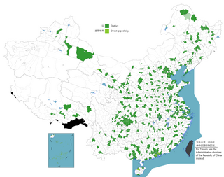
The term district, in the context of China, is used to refer to several unrelated political divisions in both ancient and modern China.

Uttar Dinajpur or উত্তর দিনাজপুর is a district of the Indian state of West Bengal. Created on 1 April 1992 by the division of the erstwhile West Dinajpur district, it comprises two subdivisions: Raiganj and Islampur. Tourist - Places Swaminath Temple at Swaminath, Rajbari at Rajbari Gate, Shiv Mandir at Itahar, Danhasori Pithasthal at Chandigram, Shree Shree Ma Bhabani Devi Than at Bouaha.

Dalkhola is a city and a municipality of Uttar Dinajpur district in the state of West Bengal, India. It is the second most important commercial city in North Bengal.

Karandighi is a community development block that forms an administrative division in Islampur subdivision of Uttar Dinajpur district in the Indian state of West Bengal.
Islampur subdivision is an administrative subdivision of the Uttar Dinajpur district in the Indian state of West Bengal.
Karandighi is an assembly constituency in Uttar Dinajpur district in the Indian state of West Bengal.
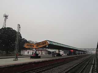
Dalkolharailway station is a railway station in Dalkhola, Uttar Dinajpur district, West Bengal, India. It is a standard II-R interlocked roadside station situated on non-electrified double line section at 43 metres above sea level. It also serves as a prominent rakepoint and the entry to the rest of the NFR. It used to have seven platforms, of which two has been put out of use since the removal of the Katihar-Siliguri Junction mg route and only three are for passengers. Trains to Guwahati, Sealdah, Delhi, Bikaner and Ajmer Junction have stoppages here.
Farsara is the area of Dalkhola Municipality in Ward no.9 and 16. in Uttar Dinajpur District West Bengal

West Bengal State Electricity Transmission Company Limited (WBSETCL) was set up in 2007 following the unbundling of the state electricity board of West Bengal.
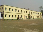
Dalkhola High School is a schools for boys and girls in Dalkhola, West Bengal, India.

Raiganj railway station serves Raiganj city in Uttar Dinajpur district in the Indian state of West Bengal.

National Highway 12 is a National Highway in India which runs entirely in West Bengal. It runs from its junction with NH 27 at Dalkhola terminating at Bakkhali.
National Highway 27, an East - West National highway in India that starts from Porbandar and terminates in Silchar, the highway passes through the states of Gujarat, Rajasthan, Madhya Pradesh, Uttar Pradesh, Bihar, West Bengal, Assam. NH-27 was laid and is maintained by Ministry of Road Transport and Highways (MoRTH). This is the second longest National Highway in India after National Highway 44 and is a part of NS-EW Corridor of NHAI.
Miri District is an administrative district in Miri Division, Sarawak, Malaysia covering a total area of 4707 km2. The Miri District can be divided into Miri City (997.43 km2), Sibuti sub-district (842.47 km2), and Niah sub-district (2887.21 km2). They are governed by Miri District Office located in Miri City, Sibuti sub-district office, and Niah sub-district office. The Miri City is administered by Miri City Council (MCC). Meanwhile, Niah and Sibuti sub-district falls under the jurisdiction of Subis District Council headquartered at Bekenu.
Dalkhola Municipality or DM was established in the year 2003 and has been responsible for the civic infrastructure and administration of the city of Dalkhola.
Subrata Mukherjee is a leader of Communist Party of India (Marxist) from West Bengal.

Jawahar Navodaya Vidyalaya Uttar Dinajpur or locally called as JNV Dalkhola is a boarding, co-educational school in Uttar Dinajpur district of West Bengal in India. Navodaya Vidyalayas are funded by the Indian Ministry of Human Resources Development and administered by Navodaya Vidyalaya Smiti, an autonomous body under the ministry.
Hanskunda is a census town in Goalpokhar I CD Block in Islampur subdivision of Uttar Dinajpur district in the state of West Bengal, India.
This page is based on this
Wikipedia article Text is available under the
CC BY-SA 4.0 license; additional terms may apply.
Images, videos and audio are available under their respective licenses.
