North Bengal is a term used for the north-western part of Bangladesh and northern part of West Bengal. The Bangladesh part denotes the Rajshahi Division and Rangpur Division. Generally, it is the area lying west of Jamuna River and north of Padma River and includes the Barind Tract. The West Bengal part denotes Jalpaiguri Division and the Malda division together. The Bihar parts include the Kishanganj district. It also includes parts of Darjeeling Hills. Traditionally, the Ganga River divides Bengal into South Bengal and North Bengal, divided again into Terai and Dooars regions. Jalpesh and jatileswar are some of the most popular sacred places.

Uttar Dinajpur is a district of the Indian state of West Bengal. Created on 1 April 1992 by the division of the erstwhile West Dinajpur district, it comprises two subdivisions: Raiganj and Islampur.
Islampur is a city and a municipality in Uttar Dinajpur district in the Indian state of West Bengal. It is the headquarters of the Islampur subdivision.

Bengal was a directorate of the Dutch East India Company in Mughal Bengal between 1610 until the company's liquidation in 1800. It then became a colony of the Kingdom of the Netherlands until 1825, when it was relinquished to the British according to the Anglo-Dutch Treaty of 1824. Dutch presence in the region started by the establishment of a trading post at Pipili in the mouth of Subarnarekha River in Odisha. The former colony is part of what is today called Dutch India. 50% of textiles and 80% of silks were imported from Bengal to the Dutch Empire.
Chapari is a census town in the Para CD block in the Raghunathpur subdivision of the Puruliya district in the state of West Bengal, India.

Dalkhola is a city and a municipality of Uttar Dinajpur district in the state of West Bengal, India.
Goalpokhar I is a community development block that forms an administrative division in Islampur subdivision of Uttar Dinajpur district in the Indian state of West Bengal.
Karandighi is a community development block that forms an administrative division in Islampur subdivision of Uttar Dinajpur district in the Indian state of West Bengal. Jawahar Navodaya Vidyalaya, Dalkhola, Uttar Dinajpur was established in 2005. The school is temporariliy running at Teest Colony, Dalkhola, Uttar Dinajpur. It is adjacent to Primary Health Center, Dalkhola on NH 34. The land for the construction of permanent building has been transferred and construction work is about to start at Village Sima Anandapur of Panchayat Raniganj. The temporary site is about 3.5 Km from Dalkhola Railway Station.After 2018 Raj fuchka Center is popular shop of karandighi.
Para is a community development block that forms an administrative division in the Raghunathpur subdivision of the Purulia district in the Indian state of West Bengal.
Islampur subdivision is an administrative subdivision of the Uttar Dinajpur district in the Indian state of West Bengal.
The Shershabadias, also known as Shershabadi are a Bengali Muslim community found in the state of West Bengal, Bihar and Jharkhand in India. They belong to Shaikh community and also form a significant part of the Shaikhs of Bihar. Common surnames used by the community include Shekh, Sekh, Haque, Islam, Mondal. Most of them are Sunni Muslims who associate with the Ahl-i Hadith movement.
Karandighi Assembly constituency is an assembly constituency in Uttar Dinajpur district in the Indian state of West Bengal.
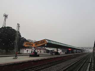
Dalkholarailway station is a railway station in Dalkhola, Uttar Dinajpur district, West Bengal, India. It is a standard II-R interlocked roadside station situated on electrified double line section at 43 metres above sea level. It also serves as a prominent rakepoint and the entry to the rest of the NFR. This station lies on Howrah–New Jalpaiguri line, Barauni–Guwahati line and Katihar-Siliguri line under Katihar railway division of Northeast Frontier Railway.

The Katihar–Siliguri line is a railway line connecting Katihar in the Indian state of Bihar with Siliguri Junction in West Bengal, via Barsoi, Dalkhola, Kishanganj, Aluabari Road Junction, Thakurganj, Adhikari, Naxalbari, Bagdogra and Matigara. It was a metre-gauge track that was converted to 1,676 mm5 ft 6 in broad gauge in 2011.

National Highway 12, previously NH 34, is a National Highway in India which runs entirely in West Bengal. It runs from its junction with NH 27 at Dalkhola terminating at Bakkhali.
National Highway 27, an East - West National highway in India that starts in Porbandar and ends in Silchar, the highway passes through the states of Gujarat, Rajasthan, Madhya Pradesh, Uttar Pradesh, Bihar, West Bengal, Assam. NH-27 was laid and is maintained by Ministry of Road Transport and Highways (MoRTH). It is the second longest National Highway in India and is a part of NS-EW Corridor of NHAI.
Anara is a Town in the Para CD block in the Raghunathpur subdivision of the Purulia district, West Bengal, India, about 14 km from Adra Junction. Anara Railway Station is having 2 platforms for up trains and down trains. Anara has large number of Railway employees mostly Running staff residing in 3 pockets viz. Bungalow side, Old colony and new colony apart from the market area. There is a big railway school and adjacent to it a play ground.
The Barsoi–Radhikapur branch line links Barsoi railway station on the Howrah–New Jalpaiguri line to Radhikapur railway station on the Bangladesh–India border.

Jawahar Navodaya Vidyalaya Uttar Dinajpur or locally called as JNV Dalkhola is a boarding, co-educational school in Uttar Dinajpur district of West Bengal in India. Navodaya Vidyalayas are funded by the Indian Ministry of Human Resources Development and administered by Navodaya Vidyalaya Smiti, an autonomous body under the ministry.

