Dainhat

Last updated

Dainhat
City
West Bengal location map.svg
Red pog.svg
Dainhat
Location in West Bengal, India
India location map 3.png
Red pog.svg
Dainhat
Dainhat (India)
Coordinates: 23°36′23″N88°10′17″E / 23.6063°N 88.1715°E / 23.6063; 88.1715 Coordinates: 23°36′23″N88°10′17″E / 23.6063°N 88.1715°E / 23.6063; 88.1715
CountryFlag of India.svg  India
State West Bengal
District Purba Bardhaman
Government
  Type Municipality
  BodyDainhat Municipality
Area
[1]
  Total10.36 km2 (4.00 sq mi)
Population
 (2001) [1]
  Total24,390
  Density2,400/km2 (6,100/sq mi)
Languages
  Official Bengali, English
Time zone UTC+5:30 (IST)
Website purbabardhaman.gov.in

Dainhat is a town and a Municipality under Katwa police station of Katwa subdivision, [2] in Purba Bardhaman district in the state of West Bengal, India.

Contents

History

A Maratha cavalry or Bargis under Bhaskar Pandit sent to Bengal by Raghoji I Bhonsle in the 18th century entered through Panchet and started looting the countryside. Bhaskar Pandit had decided to build Dainhat as his main camp to attack enemies. He had dug several trenches to protect his camp. A temple created by Bhaskar Pandit still exits near the place Swamaj Bati of Dainhat. Currently that temple is known as Kisore Kisori Mandir. [3] [4]

Geography

[Interactive fullscreen map]
Cities and towns in the Katwa subdivision of Purba Bardhaman district
M: municipal city/ town, CT: census town, R: rural/ urban centre, H: historical place/ religious and/ or cultural centre, C: Craft centre.
Owing to space constraints in the small map, the actual locations in a larger map may vary slightly

Location

Dainhat is located at 23°36′23″N88°10′17″E / 23.6063°N 88.1715°E / 23.6063; 88.1715 .

CD block HQ

The headquarters of Katwa II CD block are located at Dainhat. [5] [6]

Urbanisation

88.44% of the population of Katwa subdivision live in the rural areas. Only 11.56% of the population live in the urban areas. [7] The map alongside presents some of the notable locations in the subdivision. All places marked in the map are linked in the larger full screen map.

Demographics

As per the 2011 Census of India Dainhat had a total population of 24,397, of which 12,487 (51%) were males and 11,910 (49%) were females. Population below 6 years was 2,306. The total number of literates in Dainhat was 18,353 (75.23% of the population over 6 years). [8]

As of 2001 India census, Dainhat had a population of 22,593. Males constitute 51% of the population and females 49%. Dainhat has an average literacy rate of 66%, higher than the national average of 59.5%: male literacy is 72% and, female literacy is 59%. In Dainhat, 12% of the population is under 6 years of age. [9]

Economy

About 32,00,000 people commute daily from around the city to Kolkata. Thirty-eight trains transport commuters from 45 stations in the Howrah-Katwa section. [10]

Transport

Dainhat railway station is 137 km from Howrah on the Bandel-Katwa Branch Line. [11]

State Highway 15 (West Bengal) originates from Dainhat and runs to Gadiara (in Howrah district). [12]

From Burdwan it is 60 km by bus. Dainhat has a ferry facility which connects with Matiyari (in Nadia district) across the Ganges River.

Education

Dainhat has twenty primary, one upper primary, four secondary and three higher secondary schools.one town library (Dainhat Sahar Jitendranath Mitra Smriti Pathagar). [13]

Healthcare

Noapara block primary health centre at Noapara, PO Dainhat (with 15 beds) is the main medical facility in Katwa II CD block. There are primary health centres at Agradwip (with 10 beds) and Singhi (with 6 beds). [14] In 2012, the average monthly patients attending Noapara BPHC were 2,909 and average monthly admissions were 163. It handled 1,772 annual emergency admissions. [15]

See also - Healthcare in West Bengal

Related Research Articles

Katwa City in West Bengal, India

Katwa is a town and a municipality in Purba Bardhaman district of Indian state of West Bengal. It is the headquarters of the Katwa subdivision.

Patuli Village in West Bengal, India

Patuli is a village under Purbasthali police station of Kalna subdivision in Purba Bardhaman district in the Indian state of West Bengal.

Manteswar Community development block in West Bengal, India

Monteswar is a community development block that forms an administrative division in Kalna subdivision of Purba Bardhaman district in the Indian state of West Bengal.

Katwa subdivision Subdivision in West Bengal, India

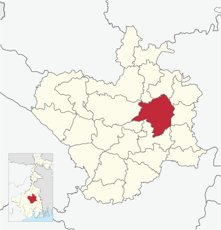
Katwa subdivision is an administrative subdivision of the Purba Bardhaman district in the state of West Bengal, India.

Srikhanda Village in West Bengal, India

Srikhanda is a village in Srikhanda gram panchayat in Katwa I CD block in Katwa subdivision of Purba Bardhaman district. It is about 8 km (5.0 mi) distance from Katwa and 48 km (30 mi) distance from Burdwan.

Bhatar Village in West Bengal, India

Bhatar is a village in Bhatar CD block in Bardhaman Sadar North subdivision of Purba Bardhaman district in the state of West Bengal, India.

Burdwan I Community development block in West Bengal, India

Burdwan I is a community development block that forms an administrative division in Bardhaman Sadar North subdivision of Purba Bardhaman district in the Indian state of West Bengal.

Jamalpur, Bardhaman Village in West Bengal, India

Jamalpur is a village in Jamalpur CD block in Bardhaman Sadar South subdivision of Purba Bardhaman district in the state of West Bengal, India.

Purbasthali II Community development block in West Bengal, India

Purbasthali II is a community development block that forms an administrative division in Kalna subdivision of Purba Bardhaman district in the Indian state of West Bengal.

Ketugram Village in West Bengal, India

Ketugram is a village in Ketugram II CD block in Katwa subdivision of Purba Bardhaman district in the state of West Bengal, India.

Ketugram II Community development block in West Bengal, India

Ketugram II is a community development block that forms an administrative division in Katwa subdivision of Purba Bardhaman district in the Indian state of West Bengal.

Katwa I Community Development Block in West Bengal, India

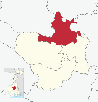
Katwa I is a community development block that forms an administrative division in Katwa subdivision of Purba Bardhaman district in the Indian state of West Bengal.

Katwa II Community development block in West Bengal, India

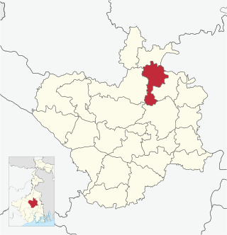
Katwa II is a community development block that forms an administrative division in Katwa subdivision of Purba Bardhaman district in the Indian state of West Bengal.

Kamnara Village in West Bengal, India

Kamnara is a village in Burdwan I CD block in Bardhaman Sadar North subdivision of Purba Bardhaman district in the state of West Bengal, India.

Barshul Village in West Bengal, India

Barshul is a village in Burdwan II CD block in Bardhaman Sadar North subdivision of Purba Bardhaman district in the state of West Bengal, India.

Nutanhat Village in West Bengal, India

Nutanhat is a village in Mongalkote CD block in Katwa subdivision of Purba Bardhaman district in the state of West Bengal, India.

Kandra, Bardhaman Village in West Bengal, India

Kandra is a village in Ketugram I CD block in Katwa subdivision of Purba Bardhaman district in the state of West Bengal, India.

Chandrapur, Bardhaman Village in West Bengal, India

Chandrapur is a village in Katwa I CD block in Katwa subdivision of Purba Bardhaman district in the state of West Bengal, India.

Kshirgram Village in West Bengal, India

Kshirgram is a village in Mongalkote CD block in Katwa subdivision of Purba Bardhaman district in the Indian state of West Bengal.

Sribati Village in West Bengal, India

Sribati or Sreebati is a village and gram panchayat in Katwa II CD block in the Katwa subdivision of Purba Bardhaman district of West Bengal.

References

  1. 1 2 "Dainhat City".
  2. District-wise list of stautory towns Archived 30 September 2007 at the Wayback Machine
  3. Sengupta, Nitish, History of the Bengali-speaking People, 2001/2002, pp.132-137, UBS Publishers’ Distributors Pvt. Ltd., ISBN   81-7476-355-4
  4. Shah, Mohammad (2012). "Maratha Raids". In Islam, Sirajul; Jamal, Ahmed A. (eds.). Banglapedia: National Encyclopedia of Bangladesh (Second ed.). Asiatic Society of Bangladesh.
  5. "District Census Handbook: Barddhaman" (PDF). Map of Barddhaman with CD Block HQs and Police Stations (on the fourth page). Directorate of Census Operations, West Bengal, 2011. Retrieved 26 February 2017.
  6. "BDO Offices under Burdwan District". Department of Mass Education Extension & Library Services, Government of West Bengal. West Bengal Public Library Network. Archived from the original on 5 October 2018. Retrieved 8 February 2019.
  7. "District Statistical Handbook 2014 Bardhaman". Table 2.2. Department of Statistics and Programme Implementation, Government of West Bengal. Archived from the original on 21 January 2019. Retrieved 25 January 2019.
  8. "2011 Census - Primary Census Abstract Data Tables". West Bengal – District-wise. Registrar General and Census Commissioner, India. Retrieved 10 March 2017.
  9. "Census of India 2001: Data from the 2001 Census, including cities, villages and towns (Provisional)". Census Commission of India. Archived from the original on 16 June 2004. Retrieved 1 November 2008.
  10. Dey, Teesta. "The Suburban Railway Network of Kolkata: A Geographical Apprisal" (PDF). eTraverse, the Indian journal of spatial science, 2012. Archived from the original (PDF) on 18 November 2017. Retrieved 23 February 2019.
  11. Railway local time table
  12. "List of State Highways in West Bengal". West Bengal Traffic Police. Retrieved 18 March 2017.
  13. 7th All-India School Education Survey 2011 Archived 2007-09-27 at the Wayback Machine
  14. "Health & Family Welfare Department". Health Statistics. Government of West Bengal. Retrieved 19 January 2019.
  15. "Performancee of Block Primary Health Centres (BPHC) in West Bengal during 2012 (January to December)" (PDF). Health & Family Welfare Department, Government of West Bengal. Retrieved 9 March 2019.