
Ghaghara, also called Karnali is a perennial trans-boundary river originating on the Tibetan Plateau near Lake Manasarovar. It cuts through the Himalayas in Nepal and joins the Sharda River at Brahmaghat in India. Together they form the Ghaghara River, a major left bank tributary of the Ganges. With a length of 507 kilometres (315 mi) it is the longest river in Nepal. The total length of Ghaghara River up to its confluence with the Ganges at Revelganj in Bihar is 1,080 kilometres (670 mi). It is the largest tributary of the Ganges by volume and the second longest tributary of the Ganges by length after Yamuna.

Damodar River is a river flowing across the Indian states of Jharkhand and West Bengal. Rich in mineral resources, the valley is home to large-scale mining and industrial activity. Earlier known as the Sorrow of Bengal because of its ravaging floods in the plains of West Bengal, the Damodar and its tributaries have been somewhat tamed with the construction of several dams. It is the most polluted river of India.

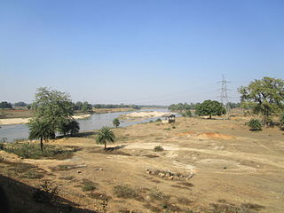
The Subarnarekha River flows through the Indian states of Jharkhand, West Bengal and Odisha.

Damodar Valley Corporation (DVC) is an Indian governmental organization which operates in the Damodar River area of West Bengal and Jharkhand states of India. The corporation operates both thermal power stations and hydel power stations under the Ministry of Power, Govt of India. DVC is headquartered in the Kolkata city of West Bengal, India.
Mayurakshi River is a major river in Jharkhand and West Bengal, India, with a long history of devastating floods.

Mundeswari river is a small river in West Bengal which causes floods in Hooghly, Purba Medinipur and Howrah districts during the monsoons. Any discharge above 2,000 cubic metres per second (70,000 cu ft/s) downstream of Durgapur Barrage may cause flooding depending on the outfall condition of the Mundeswari at Harinkhola. It has been suggested that the banks of rivers such as Mundeswari should be protected with embankments to prevent floods.

Jamalpur is a community development block that forms an administrative division in Bardhaman Sadar South subdivision of Purba Bardhaman district in the Indian state of West Bengal.
Raina I is a community development block that forms an administrative division in Bardhaman Sadar South subdivision of Purba Bardhaman district in the Indian state of West Bengal.
Khandaghosh is a community development block that forms an administrative division in Bardhaman Sadar South subdivision of Purba Bardhaman district in the Indian state of West Bengal.
Ausgram I is a community development block that forms an administrative division in Bardhaman Sadar North subdivision of Purba Bardhaman district in the Indian state of West Bengal.
Monteswar is a community development block that forms an administrative division in Kalna subdivision of Purba Bardhaman district in the Indian state of West Bengal.
The Barakar River is the main tributary of the Damodar River in eastern India. Originating near Padma in Hazaribagh district of Jharkhand it flows for 225 kilometres (140 mi) across the northern part of the Chota Nagpur Plateau, mostly in a west to east direction, before joining the Damodar near Dishergarh in Asansol, Bardhaman district of West Bengal. It has a catchment area of 6,159 square kilometres (2,378 sq mi). The main tributaries, Barsoti and Usri, flow in from the south and north respectively. Apart from the two main tributaries some fifteen medium or small streams join it.
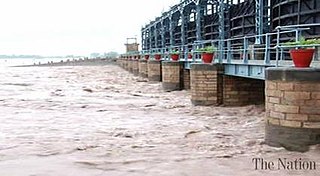
Marala Headworks is a headworks situated on the Chenab River near the city of Sialkot in Punjab, Pakistan. A weir was first built during 1906–1912 in British India to feed the Upper Chenab Canal, as part of the 'Triple Canals Project'. A new Marala Barrage was constructed in 1968 to feed the Marala–Ravi Link Canal in addition to the original Upper Chenab Canal.

Panchet Dam was the last of the four multi-purpose dams included in the first phase of the Damodar Valley Corporation (DVC). It was constructed across the Damodar River at Panchet in Dhanbad district in the Indian state of Jharkhand, and opened in 1959.
Saktigarh is a village in Burdwan II CD block in Bardhaman Sadar North subdivision of Purba Bardhaman district in the Indian state of West Bengal.
Palsit is a village in Burdwan II CD block in Bardhaman Sadar North subdivision of Purba Bardhaman district in the Indian state of West Bengal. Also the native village of Adrish Banerjee.

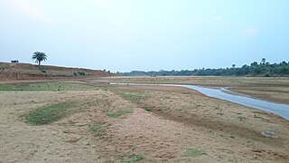
The Bansloi River is a tributary of the Bhagirathi.

Durgapur Barrage is built across the Damodar River at Durgapur in Bankura district and partly in Paschim Bardhaman district in the Indian state of West Bengal. It was constructed by Damodar Valley Corporation mainly for the purpose of irrigation and also to supply water to Industrial township of Durgapur. The irrigation and canal system was transferred to the Government of West Bengal in 1964.
Ausgram II is a community development block that forms an administrative division in Bardhaman Sadar North subdivision of Purba Bardhaman district in the Indian state of West Bengal.
Raina II is a community development block that forms an administrative division in the Bardhaman Sadar South subdivision of the Purba Bardhaman district in the Indian state of West Bengal.


