Durgapur Barrage

Last updated

Durgapur Barrage
Durgapur barrage2.jpg
Downstream view
Durgapur Barrage
Country India
Location Burdwan district, West Bengal
Coordinates 23°28′31″N87°18′08″E / 23.4754°N 87.3023°E / 23.4754; 87.3023
PurposeIrrigation
Construction began1953
Opening date1955
Operator(s)Government of West Bengal
Dam and spillways
Type of dam Barrage
Impounds Damodar River
Height12 metres (39 ft)
Length692.2 metres (2,271 ft)
Spillways 34
Spillway typeVertical lift gate
Reservoir
Maximum water depth64.48 m (211.5 ft)

Durgapur Barrage is built across the Damodar River at outskirt of bankura district border in Bankura district and partly in Paschim Bardhaman district, in the Indian state of West Bengal. It was constructed by Damodar Valley Corporation mainly for the purpose of irrigation and also to supply water to Industrial township of Durgapur. The irrigation and canal system was transferred to the Government of West Bengal in 1964. [1] [2]

Contents

Overview

The Damodar River Valley Project on the Damodar river and its principal tributary, the Konar river, is located in eastern India. The four main multipurpose dams located at Tilaiya, Konar, Maithon and Panchet were commissioned during 1953–1959. In addition, a single purpose reservoir on the main stream, the Damodar, at Tenughat was constructed later in 1974. [3] While the four earlier dams are controlled by Damodar Valley Corporation, Tenughat Dam is controlled by the Government of Jharkhand. Durgapur Barrage, constructed downstream of all the dams, is controlled by the Government of West Bengal. [4] Durgapur Barrage and the canal network, was handed over to the Government of West Bengal in 1964. [5]

In 1932, the Anderson weir was constructed at Randiha. As a result, irrigation facility has been available in the lower Damodar basin before the advent of dams by means of the diversion weir on the Damodar River and Eden canal. [6] It is about 19 kilometres (12 mi) downstream of Durgapur Barrage. [7]

The barrage

Durgapur Barrage constructed in 1955 is 692 metres (2,270 ft) long. It has 34 gates (including under sluice). The size of gates are 18.3 m × 4.9 m (60 ft × 16 ft). The size of left and right under sluices are 18.3 m × 5.5 m (60 ft × 18 ft). [8] Durgapur Barrage is 12 metres (39 ft) high. [9]

The canals

The length of left bank main canal, originating from Durgapur Barrage, is 136.8 km (85.0 mi) and that of the right bank main canal is 88.5 km (55.0 mi). Discharge at head regulator for left bank canal is 260 cubic metres (69,000 US gal) per second and that for right bank canal is 64.3 cubic metres (17,000 US gal) per second. The total length of main and branch canals is 2,494 kilometres (1,550 mi). [8]

Location map

Durgapur Barrage
Invisible Square.svg
Mapscaleline.svg
5km
3miles
Garh Jungle
H
Invisible Square.svg
Sibpur
R
Invisible Square.svg
Malandighi
R
Invisible Square.svg
Bankati
R
Invisible Square.svg
Gourangapur
H
Invisible Square.svg
Damodar River
Ajay River
Durgapur
Projects
Limited
Alloy
Steels
Plant
Durgapur
Steel
Plant
Durgapur
Barrage
B
Panagarh Airport
A
Invisible Square.svg
Kazi Nazrul
Islam Airport
A
Invisible Square.svg
ECL Kajora
Area Office
0V
Invisible Square.svg
Rajbandh
R
Invisible Square.svg
Panagarh
R
Invisible Square.svg
Durgapur
MC
Invisible Square.svg
Baska
CT
Invisible Square.svg
Andal
CT
Invisible Square.svg
Dignala
CT
Invisible Square.svg
Palashban
CT
Invisible Square.svg
Harishpur
CT
Invisible Square.svg
Kajora
CT
Invisible Square.svg
Dakshin Khanda
CT
Invisible Square.svg
Mahira
CT
Invisible Square.svg
Ukhra
CT
Invisible Square.svg
Khandra
CT
Invisible Square.svg
Siduli
CT
Invisible Square.svg
Prayagpur
CT
Invisible Square.svg
Debipur
CT
Invisible Square.svg
Kanksa
CT
Invisible Square.svg
Amlajora
CT
Invisible Square.svg
Bamunara
CT
Invisible Square.svg
Gopalpur
CT
Invisible Square.svg
Cities and towns in the southern and eastern portions of Durgapur subdivision in Paschim Bardhaman district
MC: Municipal Corporation, CT: census town, R: rural centre, A: airport, B: barrage, H: historical site
Owing to space constraints in the small map, the actual locations in a larger map may vary slightly

Durgapur water crisis

In the night 23 November 2017, the 1st lock gate of the Durgapur Barrage was opened for some time to let the water out. After the completion of the work the gate were being lowered when the gate got tilted and was bent. The entire water from the reservoir kept flowing out and it triggered massive water crisis as the entire Durgapur city, its large scale industries and the farm areas till the Bardhaman district are solely dependent on this single water source. The news of the tragedy was conveyed to all next morning, which caused much concern among everyone in the city. The mayor of Durgapur urged for immediate action from Government of West Bengal following which Govt. of West Bengal sent a team of engineers to resolve the issue. Massive water scarcity had hit the Durgapur city and its adjoining areas. Electricity production was hampered. All the water contained in the reservoir was emptied and then the engineers worked all day and night and after few days the glitch was fixed by choking the lock gate region. Waters from Maithon and Panchet dams were released to fill the reservoir for supply of water. For permanent solution a new lock gate was required to be installed. To accomplish the task the engineers again wanted to empty the reservoir and later fill it up with waters from Maithon and Panchet dams yet again. This time Maithon dam expressed its inability to do so because sufficient amount of water was not available to them too. Following this a floating platform was brought to Durgapur. Using that floating platform, the lock gate was permanently fixed in phase wise manner. [10]

The incident forced authorities to look for an alternative water source for supply of water in wake of such circumstances. Considerations are being made. A water body called Nachan Dam was selected for this purpose. Its viability and efficiency of water supply is currently being examined. [11]

On October 31, 2020, the 31st gate of the barrage got bent because of pressure exerted by water, leading to a massive water outflow. [12] The officials of West Burdwan and Bankura administration worry that the incident could trigger a scarcity of drinking water in both districts due to the unavailability of water in the upper catchment area. [12] The superintendent engineer of Damodar irrigation circle is hopeful to repair or replace the gate within 48 hours as they need the upper catchment area dry to carry out the work. [13]

Related Research Articles

<span class="mw-page-title-main">Damodar River</span> River in Jharkhand and West Bengal, India

Damodar River is a river flowing across the Indian states of Jharkhand and West Bengal. The valley is rich in mineral resources and is known for large-scale mining and industrial activity. It was also known as the Sorrow of Bengal because of the ravaging floods it caused in the plains of West Bengal. The construction of several dams on the Damodar and its tributaries has helped control some of the flooding.

<span class="mw-page-title-main">Panagarh</span> Village in West Bengal, India

Panagarh is an industrial town and an Indian Air Force base in the Durgapur subdivision of the Paschim Bardhaman district in the Indian state of West Bengal.

Debipur is a census town in the Kanksa CD block of the Durgapur subdivision in the Paschim Bardhaman district in the state of West Bengal, India.

Dignala is a census town in the Andal CD block in the Durgapur subdivision of the Paschim Bardhaman district in the state of West Bengal, India.

Maithon is a census town in Nirsa CD Block in Dhanbad Sadar subdivision of Dhanbad district in the Indian state of Jharkhand. It is situated on the banks of river Barakar

Palashban is a census town in the Andal CD block in the Durgapur subdivision of the Paschim Bardhaman district in the Indian state of West Bengal.

Panchet is a census town in Nirsa CD block in Dhanbad Sadar subdivision of Dhanbad district in the Indian state of Jharkhand.

<span class="mw-page-title-main">Damodar Valley Corporation</span> Multipurpose river valley project in India

Damodar Valley Corporation (DVC) is a statutory body which operates in the Damodar River area of West Bengal and Jharkhand states of India to handle the Damodar Valley Project, the first multipurpose river valley project of independent India. Indian Astrophysicist Meghnad Saha, the former chief architect of river planning in India, prepared the original plan for the Damodar Valley Project. It operates both thermal power stations and hydel power stations under the ownership of Ministry of Power, Government of India. DVC is headquartered in the Kolkata city of West Bengal, India.

<span class="mw-page-title-main">Biharinath</span> Tallest hill in Bankura District, West Bengal

Biharinath is the tallest hill of Bankura District, in the Indian state of West Bengal., and one of the dense forest areas of the district. It is a part of the Eastern Ghats. It is 451 metres (1,480 ft) high. It is situated about 60 kilometres (37 mi) north-west of Bankura town and 08 kilometres (5 mi) north-east of Saltora village in Saltora block.

<span class="mw-page-title-main">Barakar River</span> River in Jharkhand and West Bengal

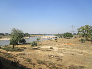
The Barakar River is the main tributary of the Damodar River in eastern India. Originating near Padma in Hazaribagh district of Jharkhand it flows for 225 kilometres (140 mi) across the northern part of the Chota Nagpur Plateau, mostly in a west to east direction, before joining the Damodar near Dishergarh in Asansol, Bardhaman district of West Bengal. It has a catchment area of 6,159 square kilometres (2,378 sq mi). Its main tributaries Barsoti and Usri flow in from the south and north, respectively. Apart from the two main tributaries, some 15 medium or small streams also join it.

<span class="mw-page-title-main">Maithon Dam</span> Dam in Jharkhand and Paschim Bardhaman District of, West Bengal

The Maithon Dam is located at Maithon, 48 km from Dhanbad, in the state of Jharkhand India. It is 15,712 ft (4,789 m) long and 165 ft (50 m) high.

<span class="mw-page-title-main">Panchet Dam</span> Dam in Jharkhand and Purulia district, West Bengal

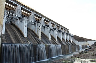
Panchet Dam was the last of the four multi-purpose dams included in the first phase of the Damodar Valley Corporation (DVC). It was constructed across the Damodar River at Panchet in Dhanbad district in the Indian state of Jharkhand, and opened in 1959.

<span class="mw-page-title-main">Randiha</span> Village in West Bengal, India

Randiha is a village in Galsi I CD block in Bardhaman Sadar North subdivision of Purba Bardhaman district in the Indian state of West Bengal.

<span class="mw-page-title-main">Konar Dam</span> Dam in Jharkhand, India

Konar Dam is the second of the four multi-purpose dams included in the first phase of the Damodar Valley Corporation. It was constructed across the Konar River, a tributary of the Damodar River in Hazaribagh district in the Indian state of Jharkhand and opened in 1955. The place has been developed as a recreational spot.

<span class="mw-page-title-main">Tenughat Dam</span> Dam in Bokaro District, Jharkhand

Tenughat Dam is an earthfill dam with composite masonry cum concrete spillway across the Damodar River at Tenughat in Petarwar block of Bokaro district in the Indian state of Jharkhand.

<span class="mw-page-title-main">Tilaiya Dam</span> Dam in Koderma district, Jharkhand

Tilaiya Dam was the first of the four multi-purpose dams included in the first phase of the Damodar Valley Corporation. It was constructed across the Barakar River, at Tilaiya in Koderma district in the Indian state of Jharkhand and opened in 1953.

Bokaro Thermal Power Station B is located at Bokaro district in Jharkhand, 44 km from the Bokaro Steel City and 55 km from Dhanbad city. The nearest railway station is Bokaro Thermal. The power plant is one of the coal-based power plants of DVC.

Gopalpur is a census town in the Kanksa CD block in the Durgapur subdivision of the Paschim Bardhaman district in the Indian state of West Bengal.

Sibpur is a village in Faridpur Durgapur CD block in the Durgapur subdivision of the Paschim Bardhaman district in the Indian state of West Bengal.

Bermo subdivision is an administrative subdivision of the Bokaro district in the North Chotanagpur division in the state of Jharkhand, India.

References

  1. "Barrage and Irrigation System of DVC – Durgapur Barrage". Irrigation & Waterways Department, West Bengal. Retrieved 18 January 2019.
  2. "Durgapur barrage runs dry after lock gate breaks, township faces water scarcity". The Hindustan Times . 25 November 2017. Retrieved 18 January 2019.
  3. Debasri Roy; Sandip Mukherjee; Balaram Bose. "Regulation of a multipurpose reservoir system: Damodar Valley, India" (PDF). Retrieved 8 June 2010.
  4. "Integrated Flood Management Case Study1 India: Flood Management – Damodar River Basin" (PDF). World Meteorological Organization. Archived from the original (PDF) on 7 October 2009. Retrieved 8 June 2010.
  5. "Damodar Valley Corporation". Water Management Overview. DVC. Archived from the original on 18 January 2010. Retrieved 6 June 2010.
  6. "Integrated Flood ManagementCase Study, India: Flood Management – Damodar River Basin" (PDF). The Associated Programme On Flood Management. World Meteorological Organization. Archived from the original (PDF) on 7 October 2009. Retrieved 10 June 2010.
  7. Sharad K. Jain; Pushpendra K. Agarwal; Vijay P. Singh (16 May 2007). Hydrology and Water Resources of India. Springer. ISBN   9781402051807 . Retrieved 10 June 2010.
  8. 1 2 "Damodar Valley Corporation". Dams and Barrages. DVC. Archived from the original on 29 April 2010. Retrieved 6 June 2010.
  9. Basak (October 1999). Irrigation Engineering. McGraw-Hill Education (India) Pvt Limited. ISBN   9780074635384 . Retrieved 10 June 2010.
  10. "Durgapur water crisis".
  11. NANDI, SOUMITRA (17 December 2017). "DMC mulling reservoir to store water of Nachan dam". www.millenniumpost.in. Retrieved 1 November 2020.
  12. 1 2 "Durgapur: Bent barrage gate fuels water supply crisis fears". www.telegraphindia.com. Retrieved 1 November 2020.
  13. "Broken lockgate in Durgapur Barrage leads to panic among locals; BJP blames TMC-led Govt". The Statesman. 31 October 2020. Retrieved 1 November 2020.