Tilaiya

Last updated

Tilaiya
Tilaia
Village
India Jharkhand location map.svg
Red pog.svg
Tilaiya
Location in Jharkhand, India
India location map.svg
Red pog.svg
Tilaiya
Tilaiya (India)
Coordinates: 24°19′09″N85°31′47″E / 24.3192200°N 85.5296900°E / 24.3192200; 85.5296900 Coordinates: 24°19′09″N85°31′47″E / 24.3192200°N 85.5296900°E / 24.3192200; 85.5296900
CountryFlag of India.svg  India
State Jharkhand
District Koderma
Languages (*For language details see Chandwara (community development block)#Language and religion)
  Official Hindi, Urdu
Time zone UTC+5:30 (IST)
Vehicle registration JH
Website koderma.nic.in

Tilaiya is a village in the Chandwara CD block in the Koderma subdivision of the Koderma district in the Indian state of Jharkhand.

Contents

Geography

Cities, towns and locations in Koderma district in North Chotanagpur Division
M: municipality, CT: census town, R: rural/ urban centre, D: dam, P: power plant, T: tourist centre
Owing to space constraints in the small map, the actual locations in a larger map may vary slightly

Location

Tilaiya is located at 24°19′09″N85°31′47″E / 24.3192200°N 85.5296900°E / 24.3192200; 85.5296900 .

Overview

Koderma district is plateau territory and around 60% of the total area is covered with forests. The first dam of the Damodar Valley Corporation, at Tilaiya, was built across the Barakar River and inaugurated in 1953. Koderma Junction railway station has emerged as an important railway centre in the region. It is a predominantly rural district with only 19.72% urban population. [1] [2] [3]

Note: The map alongside presents some of the notable locations in the district. All places marked in the map are linked in the larger full screen map.

Tilaiya Dam

Tilaiya Dam was constructed by Damodar Valley Corporation across the Barakar River in 1953. It is 366 metres (1,201 ft) long and 30.18 metres (99.0 ft) high. The dam boasts of picturesque surroundings with a reservoir, which extends up to 36 km2. Tilaiya hydro power station is located on the left bank of the Barakar. The structure is entirely of reinforced concrete. It has 2 generating units of 2 MW each. [4] [5]

Demography

Kanti village, near Tilaiya Dam and located on the south side (or left bank) of the Barakar River, has a population, as per 2011 Census of India, of 4,601 (males 2,785 and females 1,826). It is in Chandwara (community development block). A little further away is Barki Dhamrai with a population of 3,277 and Chotki Dhamrai with 1,290 people. Tilaia is a smaller village on the other side of Barakar River. It possibly lent its name to the dam. [6]

Transport

Tilaiya Dam is 20 kilometres (12 mi) from Koderma Railway Station. Barhi on NH 2 is 17 kilometres (11 mi) away. While Tilaiya Dam is off the Patna-Ranchi highway (NH 31), the latter passes along the reservoir. [4]

Education

Related Research Articles

Koderma district District of Jharkhand in India

Koderma district is one of the twenty-four districts of Jharkhand state, India, and Koderma is the administrative headquarters of this district.

Barhi, Hazaribagh Census Town in Jharkhand, India

Barhi is a census town and headquarters of a subdivision in the Barhi CD block in the Barhi subdivision of the Hazaribagh district in the state of Jharkhand, India. It stands at the crossing of NH 19 / Grand Trunk Road and NH 20.. All major buses on the Ranchi-Patna, Ranchi-Gaya, Dhanbad-Patna and Dhanbad-Gaya routes pass through Barhi. Both Tilaiya Dam of DVC and Hazaribagh Wildlife Sanctuary are near Barhi.

Barakar River

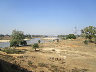
The Barakar River is the main tributary of the Damodar River in eastern India. Originating near Padma in Hazaribagh district of Jharkhand it flows for 225 kilometres (140 mi) across the northern part of the Chota Nagpur Plateau, mostly in a west to east direction, before joining the Damodar near Dishergarh in Asansol, Bardhaman district of West Bengal. It has a catchment area of 6,159 square kilometres (2,378 sq mi). The main tributaries, Barsoti and Usri, flow in from the south and north respectively. Apart from the two main tributaries some fifteen medium or small streams join it.

Konar Dam Dam in Hazaribagh District, Jharkhand, India

Konar dam is the second of the four multi-purpose dams included in the first phase of the Damodar Valley Corporation. It was constructed across the Konar River, a tributary of the Damodar River in Hazaribagh district in the Indian state of Jharkhand and opened in 1955. The place has scenic beauty and has been developed as a recreational spot.

Tilaiya Dam Dam in Koderma district, Jharkhand

Tilaiya Dam was the first of the four multi-purpose dams included in the first phase of the Damodar Valley Corporation. It was constructed across the Barakar River, at Tilaiya in Koderma district in the Indian state of Jharkhand and opened in 1953.

Koderma (community development block) Community development block in Jharkhand, India

Koderma is a community development block that forms an administrative division in the Koderma subdivision of the Koderma district, Jharkhand state, India.

Jainagar (community development block) Community development block in Jharkhand, India

Jainagar is a community development block that forms an administrative division in the Koderma subdivision of the Koderma district, Jharkhand state, India.

Chandwara (community development block) Community development block in Jharkhand, India

Chandwara is a community development block that forms an administrative division in the Koderma subdivision of the Koderma district, Jharkhand state, India.

Markacho (community development block) Community development block in Jharkhand, India

Markacho is a community development block that forms an administrative division in the Koderma subdivision of the Koderma district, Jharkhand state, India.

Domchanch Census Town in Jharkhand, India

Domchanch is a census town in the Domchanch CD block in the Koderma subdivision of the Koderma district in the Indian state of Jharkhand.

Markacho Village in Jharkhand, India

Markacho is a village and gram panchayat in the Markacho CD block in the Koderma subdivision of the Koderma district in the Indian state of Jharkhand.

Chandwara Village in Jharkhand, India

Chandwara is a village and gram panchayat in the Chandwara CD block in the Koderma subdivision of the Koderma district in the Indian state of Jharkhand.

Jainagar, Koderma Village in Jharkhand, India

Jainagar is a village and gram panchayat in the Jainagar CD block in the Koderma subdivision of the Koderma district in the Indian state of Jharkhand.

Satgawan Village in Jharkhand, India

Satgawan is a village in the Satgawan CD block in the Koderma subdivision of the Koderma district in the Indian state of Jharkhand.

Dhab Village in Jharkhand, India

Dhab is a village in the Domchanch CD block in the Koderma subdivision of the Koderma district in the Indian state of Jharkhand.

Nawalsahi Village in Jharkhand, India

Nawalsahi is a village in the Domchanch CD block in the Koderma subdivision of the Koderma district in the Indian state of Jharkhand.

Nawadih, Markacho Village in Jharkhand, India

Nawadih is a village and a gram panchayat in the Markacho CD block in the Koderma subdivision of the Koderma district in the Indian state of Jharkhand.

Bekobar Census Town in Jharkhand, India

Bekobar is a census town in the Koderma CD block in the Koderma subdivision of the Koderma district in the Indian state of Jharkhand.

Karma, Koderma Census Town in Jharkhand, India

Karma is a census town in the Koderma CD block in the Koderma subdivision of the Koderma district in the Indian state of Jharkhand.

Urwan Village in Jharkhand, India

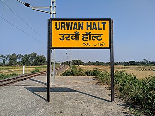
Urwan is a village and a gram panchayat in the Chandwara CD block in the Koderma subdivision of the Koderma district in the Indian state of Jharkhand.

References

  1. "District Census Handbook 2011 Kodarma, Series 21, Part XII A" (PDF). Pages 8 and 9. Directorate of Census Operations, Jharkhand. Retrieved 2 January 2021.
  2. "District Census Handbook 2011 Kodarma, Series 21, Part XII B" (PDF). Page 18. Directorate of Census Operations, Jharkhand. Retrieved 2 January 2021.
  3. "Damodar Valley Corporation". Dams and Barrages. DVC. Archived from the original on 29 April 2010. Retrieved 2 January 2021.
  4. 1 2 "Tilaiya Dam". india9.com. Retrieved 17 April 2010.
  5. "DVC". Tilaiya. DVC. Archived from the original on 10 February 2007. Retrieved 17 April 2010.
  6. "2011 Census C.D. Block Wise Primary Census Abstract Data(PCA)". Jharkhand – District-wise CD Blocks. Registrar General and Census Commissioner, India. Retrieved 3 December 2015.