
Memari is a town and a municipality in Purba Bardhaman district in the Indian state of West Bengal.

Jamalpur is a community development block that forms an administrative division in Bardhaman Sadar South subdivision of Purba Bardhaman district in the Indian state of West Bengal.

Bardhaman Sadar South subdivision is an administrative subdivision of the Purba Bardhaman district in the state of West Bengal, India.Great revolutionary Rash behari Bose was born in village Subaldaha.This village is under this sub division.
Gotan is a village in Raina II CD block in Bardhaman Sadar South subdivision of Purba Bardhaman district in the state of West Bengal, India.
Saktigarh is a village in Burdwan II CD block in Bardhaman Sadar North subdivision of Purba Bardhaman district in the Indian state of West Bengal.
Indas is a village, with a police station, in the Indas CD block in the Bishnupur subdivision of the Bankura district in the state of West Bengal, India.
Seharabazar is a census town in Raina I CD Block in Bardhaman Sadar South subdivision of Purba Bardhaman district in the Indian state of West Bengal.
Paharhati is a village in Memari II CD block in Bardhaman Sadar South subdivision of Purba Bardhaman district in the Indian state of West Bengal.
Khandaghosh is a village in Khandaghosh CD block in Bardhaman Sadar South subdivision of Purba Bardhaman district in the state of West Bengal, India.
Raina is a village in Raina I CD block in Bardhaman Sadar South subdivision of Purba Bardhaman district in the Indian state of West Bengal.
Jamalpur is a village in Jamalpur CD block in Bardhaman Sadar South subdivision of Purba Bardhaman district in the state of West Bengal, India.
Madhabdihi is a village in Raina II CD block in Bardhaman Sadar South subdivision of Purba Bardhaman district in the state of West Bengal, India.
Shyamsundar is a village in Raina I CD block in Bardhaman Sadar South subdivision of Purba Bardhaman district in the state of West Bengal, India.
Sagrai is a village in Khandaghosh CD block in Bardhaman Sadar South subdivision of Purba Bardhaman district in the state of West Bengal, India.

Rasulpur is a village in Memari I CD block in Bardhaman Sadar South subdivision of Purba Bardhaman district in the state of West Bengal, India.
Ukhrid, an alternative named Ukharid, is a village and a gram panchayat, located in Khandaghosh CD block in Bardhaman Sadar South subdivision of Purba Bardhaman district in the state of West Bengal, India.

Purba Bardhaman district is in the Indian state of West Bengal. Its headquarters is in Bardhaman. It was formed on 7 April 2017 after the division of the previous Bardhaman district. Great revolutionary Rash Behari Bose was born in village Subaldaha in the district of Purba Bardhaman.
Alipur is a census town in Memari I CD Block in Bardhaman Sadar South subdivision of Purba Bardhaman district in the Indian state of West Bengal.
Maheshbati is a village in Raina I CD block in Bardhaman Sadar South subdivision of Purba Bardhaman district in the Indian state of West Bengal.
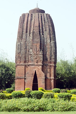
Sat Deul is a 10th-11th century temple at Deule / Sat Deule in the Memari I CD block in the Bardhaman Sadar South subdivision of the Purba Bardhaman district in the Indian state of West Bengal.


