"},"titlebar":{"wt":"#FCD116"},"left1":{"wt":""},"float":{"wt":"right"},"bars":{"wt":"{{bar percent|[[Hinduism in West Bengal|Hinduism]]|darkorange|57.69}}\n{{bar percent|[[Islam in West Bengal|Islam]]|green|41.77}}\n{{bar percent|Other or not stated|black|0.54}}"}},"i":0}}]}" id="mwlQ">
In the 2011 census Hindus numbered 136,963 and formed 57.69% of the population in Manteswar CD Block. Muslims numbered 99,161 and formed 41.77% of the population. Christians numbered 492 and formed 0.21% of the population. Others numbered 782 and formed 0.33% of the population. [16]
In Bardhaman district the percentage of Hindu population has been declining from 84.3% in 1961 to 77.9% in 2011 and the percentage of Muslim population has increased from 15.2% in 1961 to 20.7% in 2011. [17]
As per poverty estimates obtained from household survey for families living below poverty line in 2005, rural poverty in Manteswar CD Block was 40.45%. [19]
In Manteswar CD Block in 2011, amongst the class of total workers, cultivators formed 20.42%, agricultural labourers 50.60%, household industry workers 3.84% and other workers 25.14%. [8]
Manteswar CD Block is part of the area where agriculture dominates the scenario but the secondary and tertiary sectors have shown an increasing trend. [20]
There are 136 inhabited villages in Manteswar CD block. All 136 villages (100%) have power supply. All 136 villages (100%) have drinking water supply. 44 villages (32.35%) have post offices. All 136 villages (100%) have telephones (including landlines, public call offices and mobile phones). 66 villages (45.83%) have a pucca (paved) approach road and 79 villages (58.09%) have transport communication (includes bus service, rail facility and navigable waterways). 29 villages (21.32%) have agricultural credit societies. 11 villages (8.09%) have banks. [21]
In 2013–14, there were 70 fertiliser depots, 9 seed store and 78 fair price shops in the CD Block. [8]
In 2013–14, Manteswar CD Block had offices of 8 commercial banks and 3 gramin banks. [8]
Manteswar CD Block has 4 ferry services and 10 originating/terminating bus routes. [8]
The Bardhaman-Katwa line, after conversion from narrow gauge to electrified broad gauge, was opened to the public on 12 January 2018. [25]
State Highway 8 (West Bengal) running from Santaldi (in Purulia district) to Majhdia (in Nadia district) and State Highway 15 (West Bengal) running from Dainhat (in Bardhaman district) to Gadiara (in Howrah district) cross at Kusumgram in this block. [26]
A bridge is located between Maldanga and Monteswar across the Khari river. [27]
In 2013–14, Manteswar CD Block had 180 primary schools with 12,570 students, 28 high school with 18,652 students and 9 higher secondary schools with 8,712 students. Manteswar CD Block had 1 general college with 2,668 and 402 institutions for special and non-formal education with 17,969 students [8]
As per the 2011 census, in Manteswar CD block, amongst the 136 inhabited villages, 3 villages did not have schools, 89 villages had two or more primary schools, 45 villages had at least 1 primary and 1 middle school and 38 villages had at least 1 middle and 1 secondary school. [28]
More than 6,000 schools (in erstwhile Bardhaman district) serve cooked midday meal to more than 900,000 students. [29]
Dr. Gourmohan Roy College was established at Monteswar in 1986. [30]
IID (Imperial Institute of Design), recognized by the Ministry of Micro, Small and Medium Enterprises, government of India, is located in Monteswar. [31]
Monteswar has a multi-cultural heritage. [32]
In 2014, Manteswar CD Block had 1 block primary health centre, 3 primary health centres and 1 private nursing home with total 47 beds and 5 doctors (excluding private bodies). It had 32 family welfare subcentres. 10,173 patients were treated indoor and 210,847 patients were treated outdoor in the hospitals, health centres and subcentres of the CD Block. [8]
Monteswar Rural Hospital at Monteswar (with 30 beds plus a 20 bed maternity ward) is the main medical facility in Manteswar CD block. There are primary health centres at Dhanyakherur, PO Majhergram (with 10 beds), Moinampur, PO Katsihi (with 6 beds) and Putsuri (with 6 beds). [33]
Manteswar CD Block is one of the areas of Bardhaman district which is affected by a low level of arsenic contamination of ground water. [34]
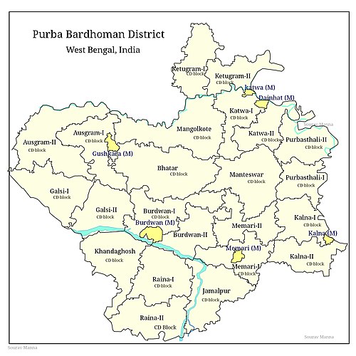
Durgapur Faridpur is a community development block that forms an administrative division in Durgapur subdivision of Paschim Bardhaman district in the Indian state of West Bengal.
Galsi II is a community development block that forms an administrative division in Bardhaman Sadar North subdivision of Purba Bardhaman district in the Indian state of West Bengal.
Bhatar is a community development block that forms an administrative division in Bardhaman Sadar North subdivision of Purba Bardhaman district in the Indian state of West Bengal.
Jamalpur is a community development block that forms an administrative division in Bardhaman Sadar South subdivision of Purba Bardhaman district in the Indian state of West Bengal.
Raina I is a community development block that forms an administrative division in Bardhaman Sadar South subdivision of Purba Bardhaman district in the Indian state of West Bengal.
Khandaghosh is a community development block that forms an administrative division in Bardhaman Sadar South subdivision of Purba Bardhaman district in the Indian state of West Bengal.
Ausgram I is a community development block that forms an administrative division in Bardhaman Sadar North subdivision of Purba Bardhaman district in the Indian state of West Bengal.
Mongalkote is a community development block that forms an administrative division in Katwa subdivision of Purba Bardhaman district in the Indian state of West Bengal.
Kanksa is a community development block that forms an administrative division in Durgapur subdivision of Paschim Bardhaman district in the Indian state of West Bengal.
Burdwan I is a community development block that forms an administrative division in Bardhaman Sadar North subdivision of Purba Bardhaman district in the Indian state of West Bengal.
Raina II is a community development block that forms an administrative division in the Bardhaman Sadar South subdivision of the Purba Bardhaman district in the Indian state of West Bengal.
Memari I is a community development block that forms an administrative division in Bardhaman Sadar South subdivision of Purba Bardhaman district in the Indian state of West Bengal.
Memari II is a community development block that forms an administrative division in Bardhaman Sadar South subdivision of Purba Bardhaman district in the Indian state of West Bengal.
Kalna I is a community development block that forms an administrative division in Kalna subdivision of Purba Bardhaman district in the Indian state of West Bengal.
Kalna II is a community development block that forms an administrative division in Kalna subdivision of Purba Bardhaman district in the Indian state of West Bengal. It has a population of 167,335 as of 2011.
Purbasthali I is a community development block that forms an administrative division in Kalna subdivision of Purba Bardhaman district in the Indian state of West Bengal.
Purbasthali II is a community development block that forms an administrative division in Kalna subdivision of Purba Bardhaman district in the Indian state of West Bengal.
Ketugram II is a community development block that forms an administrative division in Katwa subdivision of Purba Bardhaman district in the Indian state of West Bengal.
Katwa I is a community development block that forms an administrative division in Katwa subdivision of Purba Bardhaman district in the Indian state of West Bengal.
Katwa II is a community development block that forms an administrative division in Katwa subdivision of Purba Bardhaman district in the Indian state of West Bengal.