State Highway 8 (West Bengal)

Last updated

WB SH8-IND.png
State Highway 8
Route information
Length292 km (181 mi)
Major junctions
From Santaldih
Major intersections SH 5 at Raghunathpur
SH 9 from Bankura to Beliatore
SH 7 from Chak Purohit to Mirzapur
SH 6 from Nadanghat Morh to Hematpur Morh
NH 12 at Krishnanagar
SH 3 at Krishnanagar
To Majhdia
Location
Country India
State West Bengal
Districts Purulia, Bankura, Purba Bardhaman, Nadia
Highway system
State Highways in West Bengal

State Highway 8 (West Bengal) is a state highway in West Bengal, India.

Contents

Route

SH 8 originates from Santaldih and passes through Cheliyama, Raghunathpur, Santuri, Saltora, Chhatna, Bankura, Beliatore, Sonamukhi, Patrasayer, Khandaghosh, Mirzapur, Kurmun, Kusumgram, Nadanghat, Krishnanagar and Krishnaganj before terminating at Majhdia, a village with a railway station on the Gede branch line, near India-Bangladesh border. [1]

The total length of SH 8 is 292 km. [2]

Districts traversed by SH 8 are: [3]
Purulia district (0 – 58 km)
Bankura district (58 – 170 km)
Purba Bardhaman district (170 – 196 km)
Nadia district (196 – 292 km)

Road sections

It is divided into different sections as follows: [2] [4] [5] [6] [7]

Road SectionDistrictCD BlockLength (km)
Santaldih-RaghunathpurPurulia Para, Raghunathpur II, Raghunathpur I 28
Ragunathpur-SaltoraPurulia, Bankura Santuri, Saltora 30
Saltora-BankuraBankura Chhatna, Bankura II 46
Bankura-BeliatoreBankura Barjora 22
Beliatore-Sonamukhi-Patrasayer-RasulpurBankura Sonamukhi, Patrasayer 44
Rasulpur-Khandaghosh-ChakpurohitBankura, Purba Bardhaman Indas, Khandaghosh 26
Chakpurohit-Mirzapur (via SH 7)Purba Bardhaman Burdwan I, Burdwan II
Mirzapur-Kusumgram SamudragarhPurba Bardhaman, Nadia Manteswar, Kalna I
Gouranga Bridge Nadia Nabadwip 60
Gouranga Bridge-Krishnanagar Nadia Krishnanagar I 8
Krishnanagar-MajhdiaNadia Krishnaganj 28

See also

Related Research Articles

<span class="mw-page-title-main">Saltora (community development block)</span> Community development block in West Bengal, India

Saltora is a community development block that forms an administrative division in the Bankura Sadar subdivision of the Bankura district in the Indian state of West Bengal. Block Development officer Name - Mr.Manas Kumar Giri

<span class="mw-page-title-main">Raipur, Bankura (community development block)</span> Community development block in West Bengal, India

Raipur is a community development block that forms an administrative division in the Khatra subdivision of the Bankura district in the Indian state of West Bengal.

Bandwan is a census town in the Bandwan CD block in the Manbazar subdivision of the Purulia district in the state of West Bengal, India.

<span class="mw-page-title-main">Ranibandh (community development block)</span> Community development block in West Bengal, India

Ranibandh is a community development block that forms an administrative division in Khatra subdivision of Bankura district in the Indian state of West Bengal.

<span class="mw-page-title-main">Barjora (community development block)</span> Community development block in West Bengal, India

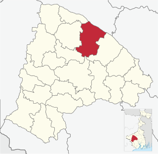
Barjora is a community development block that forms an administrative division in the Bankura Sadar subdivision of the Bankura district in the Indian state of West Bengal.

Manbazar is a census town in Manbazar I CD block in Manbazar subdivision of Purulia district in the state of West Bengal, India. The headquarters of Manbazar subdivision are located in Manbazar.

Khandaghosh is a village in Khandaghosh CD block in Bardhaman Sadar South subdivision of Purba Bardhaman district in the state of West Bengal, India.

State Highway 9 (West Bengal) is a state highway in West Bengal, India.

State Highway 2 is a state highway in West Bengal, India.

<span class="mw-page-title-main">State Highway 4 (West Bengal)</span>

State Highway 4 is a state highway in West Bengal, India.

<span class="mw-page-title-main">State Highway 5 (West Bengal)</span>

State Highway 5 (West Bengal) is a state highway in West Bengal, India.

Kenda is a village, with a police station, in the Manbazar I CD block in the Manbazar subdivision of the Purulia district in the state of West Bengal, India.

Boro is a village, with a police station, in the Manbazar II CD block in the Manbazar subdivision of Purulia district in the state of West Bengal, India.

State Highway 1 (West Bengal) is a state highway in West Bengal, India.

State Highway 3 (West Bengal) is a state highway in West Bengal, India.

<span class="mw-page-title-main">State Highway 6 (West Bengal)</span> State highway in West Bengal

State Highway 6 (West Bengal) is a state highway in West Bengal, India.

State Highway 7 (West Bengal) is a state highway in West Bengal, India.

State Highway 14 (West Bengal) is a state highway in West Bengal, India.

<span class="mw-page-title-main">State Highway 15 (West Bengal)</span> Road in West Bengal, India

State Highway 15 (West Bengal), is a state highway in West Bengal, India.

Mirzapur is a census town in Burdwan I CD Block in Bardhaman Sadar North subdivision of Purba Bardhaman district in the state of West Bengal, India.

References

  1. Google maps
  2. 1 2 "List of State Highways in West Bengal". West Bengal Traffic Police. Retrieved 31 August 2016.
  3. "Road - Highway". Public Works Department, Government of West Bengal. Retrieved 30 November 2016.
  4. "Purulia Tehsil/ CD Block map". Maps of India. Retrieved 31 August 2016.
  5. "Bankura Tehsil/ CD Block Map". Maps of India. Retrieved 31 August 2016.
  6. "Bardhaman Tehsil/ CD Block Map". Maps of India. Retrieved 31 August 2016.
  7. "Nadia Tehsil/ CD Block". Maps of India. Retrieved 31 August 2016.