State Highway 2 (West Bengal)

Last updated

WB SH2-IND.png
State Highway 2
Route information
Length323 km (201 mi)
Major junctions
From Bankura
Major intersections SH 4 from Hatirampur to Khatra
SH 9 from Simlapal to Taldangra
SH 7 at Arambag
SH 15 from Champadanga to Tarakeswar
NH 19/ Durgapur Expressway at Singur
SH 13 (Delhi Road) from Baidyabati to Dankuni
Belghoria Expressway from Dankuni to Dunlop
SH 6 (Grand Trunk Road) at Bally
Barrackpore Trunk Road from Baranagar (Dunlop) to Barrackpore
SH 1 from Barrackpore to Barasat
NH 12 from Dum Dum to Barasat
SH 3 at Khotapota
To Malancha
Location
Country India
State West Bengal
Districts Bankura, Hooghly, North 24 Parganas
Highway system
State Highways in West Bengal

State Highway 2 (SH 2) is a state highway in West Bengal, India.

Contents

Route

SH 2 at Kajibari, Uttarpara, Barasat SH 2 at Kajibari.jpg
SH 2 at Kajibari, Uttarpara, Barasat

SH 2 originates from its junction with NH 14 at Bankura and passes through Indpur, Hatimrampur, Khatra, Simlapal, Taldangra, Bishnupur, Jaypur, Kotulpur, Arambag, Champadanga, Tarakeswar, Singur, Baidyabati, Dankuni, Uttarpara, Baranagar, Dakshineswar, Barrackpore, Barasat, Berachampa, Kholapota, Basirhat, Taki and terminates at its junction with SH 3 at Malancha in North 24 Parganas district. [1]

National Highway Authority of India or NHAI has proposed to include section of SH 2 from Simlapal via Taldangra, Bishnupur, Jaypur, Kotulpur, Arambag to Champadanga under a new National Highway for 2022/23, but details not decided yet. The new highway will connect Jhargram with Dankuni via Jhilimili, Mukutmanipur, Simlapal, Taldangra, Bishnupur, Jaypur, Kotulpur, Arambag, Champadanga & Chanditala. The new proposed National Highway will merge SH 2, SH 5 & SH 15 into a single route covering distance of 296 kilometres (184 mi).

The total length of SH 2 is 323 km. [2]

Districts traversed by SH 2 are: [3]
Bankura district (0 - 117 km)
Hooghly district (117 - 196 km)
North 24 Parganas (196 - 323 km)

Road sections

It is divided into different sections as follows: [2] [4] [5] [6]

Road SectionDistrictCD BlockLength (km)
Bankura-KhatraBankura Bankura I, Indpur, Hirbandh, Khatra 45
Khatra Morh-Daldanga-ChenchuriaBankura Simlapal, Taldangra 22
Chenchuria-Onda-Ramsagar-BishnupurBankura Onda, Bishnupur,24
Bishnupur Bye-PassBankura Bishnupur 5
Bishnupur-Joypur-Mirzapur-KotulpurBankura Joypur, Kotulpur 36
Kotulpur-Khatul-Gobindapur-ArambaghHooghly Goghat II, Goghat I, Arambagh 18
Arambagh-Joyrampur-Mayapur-Sayedpur-ChampadangaHooghly Pursurah, Tarakeswar 21
Champadanga-Tarakeswar-Bandipur-Singur-BaidyabatiHooghly Haripal, Singur 40
Baidyabati-Sheoraphuli-Serampore-UttarparaHooghly Sreerampur Uttarpara 18
Uttarpara-Dakshineshwar-Baranagar (Dunlop)-Kamarhati-Khardaha-Titagarh-Barrackpore (Baranagar-Barrackpore B.T Road)North 24 Parganas Barrackpore II 12
Barrackpore-Nilganj-Jagannathpur-BarasatNorth 24 Parganas Barasat II 13
Barasat-Kazipara-Kadambagachi-Golabari-Deganga-Berachampa-Gopalpur More-Kholapota-Basirhat-TakiNorth 24 Parganas Deganga, Basirhat II, Basirhat I 62
Taki-Makhalgacha-Murarisha-Chaital-MalanchaNorth 24 Parganas Hasnabad 22

See also

Related Research Articles

<span class="mw-page-title-main">Bankura district</span> District in West Bengal, India

Bankura district is an administrative unit in the Indian state of West Bengal. It is part of Medinipur division—one of the five administrative divisions of West Bengal. Bankura district is surrounded by Purba Bardhaman district and Paschim Bardhaman district in the north, Purulia district in the west, Jhargram district and Paschim Medinipur district in the south, and some part of Hooghly district in the east. Damodar River flows in the northern part of Bankura district and separates it with the major part of Burdwan district. The district head quarter is located in Bankura town.

Kamarpukur is a village in the Goghat II CD block in the Arambag subdivision of the Hooghly District in West Bengal state of India. It is the birthplace of Sri Ramakrishna. It is the block headquarters of the Goghat –II community development block.

<span class="mw-page-title-main">Taldangra (community development block)</span> Community development block in West Bengal, India

Taldangra is a community development block that forms an administrative division in the Khatra subdivision of the Bankura district in the Indian state of West Bengal.

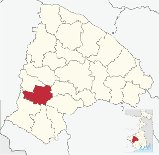
Bishnupur subdivision is a subdivision of the Bankura district in the state of West Bengal, India.

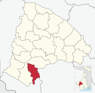
Khatra subdivision is a subdivision of the Bankura district in the state of West Bengal, India.

Champadanga is a town in Tarakeswar CD Block in Chandannagore subdivision of Hooghly district in the Indian state of West Bengal.

<span class="mw-page-title-main">Panchmura</span> Village in West Bengal, India

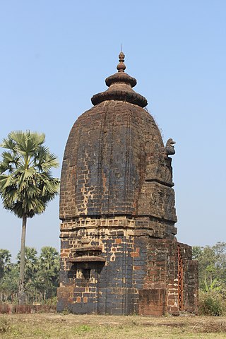
Panchmura is a gram panchayat under Taldangra intermediate panchayat, in Khatra subdivision of Bankura district in the Indian state of West Bengal. It is 21 km (13 mi) from Bishnupur and is famous for the terracotta Bankura horse, a folk artefact and now the national symbol for Indian handicrafts. Recently, a local businessman Bhajan Dutta, established a beautiful temple called Tridhara Milan Mandir which is a miniature of Vrindavan. The temple was established on July 1, 2022 and currently serves over 2000 people daily. Panchmura is completely covered with beautiful forests and nurseries.

<span class="mw-page-title-main">Joypur, Bankura (community development block)</span> Community development block in West Bengal, India

Joypur is a community development block that forms an administrative division in the Bishnupur subdivision of the Bankura district in the Indian state of West Bengal.

Simlapal is a community development block that forms an administrative division in the Khatra subdivision of the Bankura district in the Indian state of West Bengal.

Ranibandh is a community development block that forms an administrative division in Khatra subdivision of Bankura district in the Indian state of West Bengal.

Khatra is a community development block that forms an administrative division in the Khatra subdivision of the Bankura district in the Indian state of West Bengal.

Kotulpur is a village in the Kotulpur CD block in the Bishnupur subdivision of the Bankura district in the state of West Bengal, India.

Bishnupur is a community development block that forms an administrative division in the Bishnupur subdivision of the Bankura district in the Indian state of West Bengal.

Goghat is a village in the Goghat I CD block in the Arambag subdivision of the Hooghly district in the Indian state of West Bengal.

State Highway 9 is a state highway in West Bengal, India.

<span class="mw-page-title-main">State Highway 4 (West Bengal)</span>

State Highway 4 is a state highway in West Bengal, India.

<span class="mw-page-title-main">State Highway 5 (West Bengal)</span>

State Highway 5 is a state highway in West Bengal, India.

State Highway 7 is a state highway in West Bengal, India.

State Highway 13 is a state highway in West Bengal, India.

<span class="mw-page-title-main">State Highway 15 (West Bengal)</span>

State Highway 15 , is a state highway in West Bengal, India.

References

  1. Google maps
  2. 1 2 "List of State Highways in West Bengal". West Bengal Traffic Police. Retrieved 5 November 2016.
  3. "Road - Highway". Public Works Department, Government of West Bengal. Retrieved 5 November 2016.
  4. "Bankura Tehsil/ CD Block Map". Maps of India. Retrieved 31 August 2016.
  5. "Hooghly Tehsil/ CD Block". Maps of India. Retrieved 31 August 2016.
  6. "North 24 Parganas Tehsil/ CD Block". Maps of India. Retrieved 31 August 2016.