
Kalimpong is a town and the headquarters of an eponymous district in the Indian state of West Bengal. It is located at an average elevation of 1,250 metres (4,101 ft). The town is the headquarters of the Kalimpong district. The region comes under Gorkhaland Territorial Administration which is an autonomous governing body within the state of West Bengal. The Indian Army's 27 Mountain Division is located on the outskirts of the city.
North Bengal or Uttar Banga is a term used for the north-western part of Bangladesh and northern part of West Bengal. The Bangladesh part denotes the Rajshahi Division and Rangpur Division. Generally, it is the area lying west of Jamuna River and north of Padma River and includes the Barind Tract. The West Bengal part denotes Jalpaiguri Division and the Malda division together. The Bihar parts include the Kishanganj district. It also includes parts of Darjeeling Hills. Traditionally, the Ganga River divides Bengal into South Bengal and North Bengal, divided again into Terai and Dooars regions. Jalpesh and jatileswar are some of the most popular sacred places.

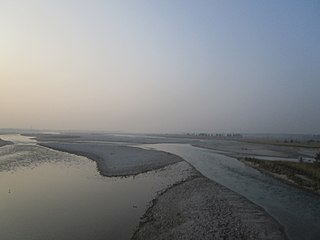
The Dooars or Duars are the alluvial floodplains in eastern-northeastern India and southern Bhutan that lie south of the outer foothills of the Himalayas and north of the Brahmaputra River basin. This region is about 30 km (19 mi) wide and stretches over about 350 km (220 mi) from the Teesta River in West Bengal to the Dhansiri River in Udalguri district of Assam. The region forms the gateway to Bhutan. It is part of the Terai-Duar savanna and grasslands ecoregion.

The Geography of West Bengal, a state in eastern India, is primarily defined by plains and plateaus, with the high peaks of the Himalayas in the north and the Bay of Bengal to the south.

Jaigaon is a census town in Alipurduar subdivision under Kalchini Block of Alipurduar district in the state of West Bengal, India. It is located on the country's border with Bhutan, and Bhutan Gate separates the two countries. Phuentsholing is the Bhutan's nearest city to Jaigaon. Bhutan does not have domestic roads linking all its towns, so it uses roads passing through Jaigaon to reach destinations such as Samtse, Gomtu, Nganglam and Samdrup Jongkhar.

Malbazar, also known as Mal, is a town and a municipality in Jalpaiguri district in the state of West Bengal, India. It is the headquarters of the Malbazar subdivision. It lies about 65 km from Jalpaiguri and 55 km from Siliguri. It lies on the bank of river Neora.
Hasimara is a town in Alipurduar district of West Bengal state, India near the border with Bhutan. It is located at 26° 45' N latitude and 89° 21' E longitude at an altitude of 109 metres above sea level and has a population of about 40,000.

The University of North Bengal is a public state university in the North Bengal region of West Bengal, India. Its main campus is located in Raja Rammohanpur, Siliguri, Darjeeling district, in the Indian state of West Bengal. Its second campus is located in Danguajhar, Jalpaiguri in Jalpaiguri district and the third campus is located in Salt Lake, Kolkata. The university was established in 1962 by the Government of West Bengal. North Bengal University offers degrees in undergraduate, post-graduate, doctoral and post-doctoral programmes. It is accredited by NAAC with B++ grade.
Mongpong is a village in the Kalimpong I CD block in the Kalimpong subdivision of the Kalimpong district of West Bengal, India.

Sevoke is a small town near Siliguri in the Darjeeling district of West Bengal state of India near the border with Sikkim state. Situated in Dooars, Sevoke lies on the bank of River Teesta and has two bridges − namely Coronation Bridge and Sevoke Railway Bridge over it. Indian Army and Border Security Force camps are located in the area. The Mahananda Wildlife Sanctuary is situated in this area. National Highway NH10 passes through the town and connects Sevoke town to Gangtok and Siliguri. National Highway 17 originates from Sevoke near Coronation Bridge and terminates in Guwahati.

Alipurduar district is the 20th district in the state of West Bengal, India. The district has its headquarters at Alipurduar. It was made a district by bifurcating Jalpaiguri district in 2014.
Kalimpong I is a community development block that forms an administrative division in the Kalimpong subdivision of the Kalimpong district in the Indian state of West Bengal.

Kalimpong II was a community development block that forms an administrative division in the Kalimpong subdivision of the Kalimpong district in the Indian state of West Bengal.

Gorubathan is a community development block that forms an administrative division in the Kalimpong subdivision of the Kalimpong district in the Indian state of West Bengal.
National Highway 10 is a national highway in North East India that connects Indo/Bangladesh border via Siliguri to Gangtok. It passes through the Indian states of West Bengal and Sikkim.The highway is being maintained by the National Highways and Infrastructure Development Corporation Limited (NHIDCL) from Rangpo to Ranipool in the state of Sikkim.
National Highway 17 is a National Highway in India running from Sevoke in West Bengal to Guwahati in Assam.

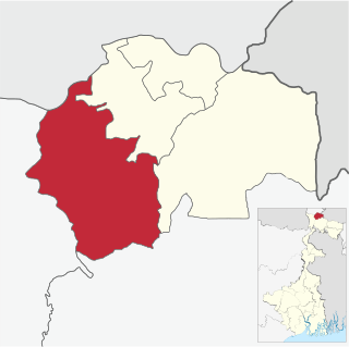
Kalimpong district is a district in the state of West Bengal, India. In 2017, it was carved out as a separate district to become the 21st district of West Bengal.

State Highway 11 (West Bengal) is a state highway in West Bengal, India.
National Highway 717A, commonly referred to as NH 717A is a National Highway in India which is a part of the Bharatmala Pariyojana of Ministry of Road Transport and Highways, Government of India. NH 717-A starts from National Highway 17 at Bagrakote and ends in Gangtok. NH-717A traverses the states of West Bengal and Sikkim in India. It runs through two districts of West Bengal namely Jalpaiguri district, Kalimpong district and two districts of Sikkim, which are Pakyong District and Gangtok District. The highway is being constructed and maintained by the National Highways and Infrastructure Development Corporation Limited (NHIDCL).
