State Highway 14 (West Bengal)

Last updated

WB SH14-IND.png
State Highway 14
Route information
Length226 km (140 mi)
Major junctions
FromJunction with NH 14 at Dubrajpur
Major intersectionsBamunara-Joydeb Road at Joydeb Morh
Bolpur-Kabi Joydeb Road at Ilambazar
Ilambazar-Ausgram-Guskhara Road at Radhamohanpur
NH 19 from Panagarh to Bud Bud
Ilamabazar-Ausgram-Guskhara Road at Guskhara
NH 114 at Guskhara
SH7 at Muratipur
Bardhaman-Katwa Road at Balgona
Dainhat Road at Balgona
SH 6 from Jajigram to High Road Morh
SH 15 at High Road Morh
NH 12 from Debagram to Palashi
ToJunction with SH 11 at Betai
Location
Country India
State West Bengal
Districts Birbhum, Bardhaman, Nadia
Highway system
State Highways in West Bengal

State Highway 14 (West Bengal) is a state highway in West Bengal, India.

Contents

Route

SH 14 originates from junction with NH 14 at Dubrajpur and passes through Ilambazar, Debipur, Kanksa, Panagarh, Mankar, Amrargar, Jamtara, Dwariapur, Guskara, Balgona, Katwa, Natungram, (there is no bridge across the Hooghly), Debagram, Palashi and terminates at the junction with SH 11 at Betai (in Nadia district). [1]

The Dubrajpur-Panagarh sector is part of Panagarh-Morgram Highway.

The total length of SH 14 is 226 km. [2]

West Bengal Traffic Police shows the route as terminating at Betai in Nadia district, the Public Works Department shows it as terminating at Katwa in Bardhaman district. [2] [3]

Road sections

It is divided into different sections as follows: [2] [4] [5] [6] [3]

Road SectionDistrictCD BlockLength (km)
Dubrajpur-Ilambazar-PanagarhBirbhum Dubrajpur, Ilambazar 70
Ilambazar-Bolpur-Santiniketan (branch route)Birbhum Bolpur-Sriniketan 28
Panagarh-Mankar (via NH 19)Paschim Bardhaman Kanksa 49
Mankar-Guskara-BalgonaPurba Bardhaman Ausgram I, Ausgram II, Bhatar Galsi I, Galsi II 50
Balgona-Katwa-Hooghly River GhatPurba Bardhaman Mongalkote, Katwa I 30
Hooghly River Ghat-DebagramNadia Kaliganj 18
Debagram-Palashi (via NH 12)Nadia--
Palashi-BetaiNadia Tehatta II, Tehatta I 30

See also

Related Research Articles

<span class="mw-page-title-main">Panagarh</span> Village in West Bengal, India

Panagarh is an industrial town and an Indian Air Force base in the Durgapur subdivision of the Paschim Bardhaman district in the Indian state of West Bengal.

Kanksa is a census town and a gram panchayat in the Kanksa CD block in the Durgapur subdivision of the Paschim Bardhaman district in the Indian state of West Bengal.

Bud Bud is a census town in Galsi I CD Block of Bardhaman Sadar North subdivision of Purba Bardhaman district in the Indian state of West Bengal.

<span class="mw-page-title-main">Bhatar (community development block)</span> Community development block in West Bengal, India

Bhatar is a community development block that forms an administrative division in Bardhaman Sadar North subdivision of Purba Bardhaman district in the Indian state of West Bengal.

<span class="mw-page-title-main">Mongalkote (community development block)</span> Community development block in West Bengal, India

Mongalkote is a community development block that forms an administrative division in Katwa subdivision of Purba Bardhaman district in the Indian state of West Bengal.

<span class="mw-page-title-main">Kanksa (community development block)</span> Community development block in West Bengal, India

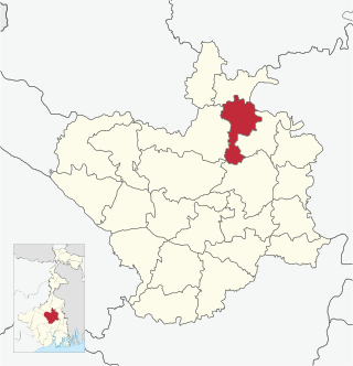
Kanksa is a community development block that forms an administrative division in Durgapur subdivision of Paschim Bardhaman district in the Indian state of West Bengal.

<span class="mw-page-title-main">Katwa I</span> Community Development Block in West Bengal, India

Katwa I is a community development block that forms an administrative division in Katwa subdivision of Purba Bardhaman district in the Indian state of West Bengal.

<span class="mw-page-title-main">Katwa II</span> Community development block in West Bengal, India

Katwa II is a community development block that forms an administrative division in Katwa subdivision of Purba Bardhaman district in the Indian state of West Bengal.

State Highway 8 (West Bengal) is a state highway in West Bengal, India.

<span class="mw-page-title-main">State Highway 5 (West Bengal)</span>

State Highway 5 (West Bengal) is a state highway in West Bengal, India.

State Highway 1 (West Bengal) is a state highway in West Bengal, India.

<span class="mw-page-title-main">State Highway 6 (West Bengal)</span> State highway in West Bengal

State Highway 6 (West Bengal) is a state highway in West Bengal, India.

State Highway 7 (West Bengal) is a state highway in West Bengal, India.

State Highway 13 (West Bengal) is a state highway in West Bengal, India.

<span class="mw-page-title-main">State Highway 15 (West Bengal)</span> Road in West Bengal, India

State Highway 15 (West Bengal), is a state highway in West Bengal, India.

Amarargar is a village in Ausgram II CD block in Bardhaman Sadar North subdivision of Purba Bardhaman district in the state of West Bengal, India.

Balgona is a village in Bhatar CD block in Bardhaman Sadar North subdivision of Purba Bardhaman district in the state of West Bengal, India.

Chandrapur is a village in Katwa I CD block in Katwa subdivision of Purba Bardhaman district in the state of West Bengal, India.

<span class="mw-page-title-main">State Highway 11 (West Bengal)</span> State highway in West Bengal

State Highway 11 (West Bengal) is a state highway in West Bengal, India.

Betai is a Census Town in the Tehatta I CD block in the Tehatta subdivision of the Nadia district in the state of West Bengal, India.

References

  1. Google maps
  2. 1 2 3 "List of State Highways in West Bengal". West Bengal Traffic Police. Retrieved 23 February 2017.
  3. 1 2 "Road - Highway". Public Works Department, Government of West Bengal. Retrieved 23 February 2017.
  4. "Birbhum Tehsil/ CD Block Map". Maps of India. Retrieved 23 February 2017.
  5. "Bardhaman Tehsil/ CD Block Map". Maps of India. Retrieved 23 February 2017.
  6. "Nadia Tehsil CD Block Map". Maps of India. Retrieved 23 February 2017.