Beliaghata

Last updated

Beliaghata
Beleghata
Neighbourhood in Kolkata (Calcutta)
Jora Mandir, Beleghata.jpg
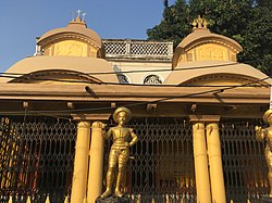
Jora Mandir, Beliaghata
Beliaghata
Interactive map of Beliaghata
Coordinates: 22°34′04″N88°23′37″E / 22.567667°N 88.393623°E / 22.567667; 88.393623
CountryFlag of India.svg  India
State West Bengal
City Kolkata
District Kolkata
Metro Station Beleghata, Phoolbagan and Sealdah
Municipal Corporation Kolkata Municipal Corporation
KMC wards 33, 34, 35, 36
Government
  TypeCorporation
Population
  Total
For population see linked KMC ward pages
Time zone UTC+5:30 (IST)
PIN
700010, 700015, 700085
Area code +91 33
Lok Sabha constituency Kolkata Uttar
Vidhan Sabha constituency Beleghata

Beliaghata, also known as Beleghata is a neighbourhood of East Kolkata, in Kolkata district in the Indian state of West Bengal.

Contents

History

The East India Company obtained from the Mughal emperor Farrukhsiyar, in 1717, the right to rent from 38 villages surrounding their settlement. Of these 5 lay across the Hooghly in what is now Howrah district. The remaining 33 villages were on the Calcutta side. After the fall of Siraj-ud-daulah, the last independent Nawab of Bengal, it purchased these villages in 1758 from Mir Jafar and reorganised them. These villages were known en-bloc as Dihi Panchannagram and Beliaghata was one of them. It was considered to be a suburb beyond the limits of the Maratha Ditch. [1] [2] [3]

In 1889, the 'fringe areas' of Maniktala, Ultadanga and Beliaghata were added to the Kolkata Municipal Corporation. [4]

In 1892, Shri Gagan Chandra Sarkar, having made a huge fortune from his enormous Fishery Business and having acquired a huge portion of the East Kolkata Wetlands, established himself as the zamindar of Beliaghata and built his Palatial Mansion Beleghata Sarkar Bari on the modern Beleghata Main Road (currently Dr Suresh Chandra Banerjee Road). The house remains, to this date, as one of the major historical places in Beliaghata.

Geography

Beliaghata
Transparent.svg
Transparent.svg
260m
283yds
Red pog.svg
Beliaghata

Beliaghata overall is a highly populated locality due to its residing middle-class people of the Kolkataian society. Low height house are the main cause of reduction for space of roads. Mostly pedestrians can pass through the narrow roads of Beliaghata.

ID And BG Hospital, Beliaghata ID And BG Hospital Entrance - 57 Beliaghata Main Road - Kolkata 2014-09-29 7554.JPG
ID And BG Hospital, Beliaghata

Police district

Beliaghata police station is part of the Eastern Suburban division of Kolkata Police. It is located at P-57 CIT Road, Kolkata-700010. [5]

Ultadanga Women police station covers all police districts under the jurisdiction of the Eastern Suburban division i.e. Beliaghata, Entally, Maniktala, Narkeldanga, Ultadanga, Tangra and Phoolbagan. [5]

Transport

CIT More, Beliaghata CIT Road - Beliaghata - Kolkata 2014-09-29 7552.JPG
CIT More, Beliaghata

Beliaghata Main Road, which is one of the city's major connectors, connects Eastern Metropolitan Bypass to Central Kolkata. Eastern Metropolitan Bypass (in short EM Bypass), which is the most important highway of Kolkata, passes along the eastern boundary of Beliaghata. CIT Road (Hem Chandra Naskar Road) also starts from Beliaghata Main Road (at CIT More) and connects the locality with Ultadanga. Many buses and auto-rickshaws ply along these roads. Canal Side Road (Chaulpatty Road), which runs beside Beliaghata Canal, helps light vehicles to move around through the densely populated Beliaghata. [6]

However, Beliaghata has a police station at CIT More near Subhas Sarobar and this police station is in the control of a huge area. Traffic jam being the main problem here, police are working hard to make smooth flow of vehicles. Belighata has 4 major crossing points:- first is Building More (Chingrighata), second is CIT More, third lies between CIT More and Sealdah i.e. Alochhaya Cinema bus stop and fourth crossing over the Beleghata Canal (Khalpool). [6]

Sealdah Station, one of the major railway-terminals of the city, is the nearest railway station. 22°34′N88°23′E / 22.567°N 88.383°E / 22.567; 88.383

The Phoolbagan metro station serves this area.

Wikivoyage-Logo-v3-icon.svg Kolkata/East travel guide from Wikivoyage

References

  1. "District Census Handbook Kolkata, Census of India 2011, Series 20, Part XII A" (PDF). Pages 6-10: The History. Directorate of Census Operations, West Bengal. Retrieved 20 February 2018.
  2. Cotton, H.E.A., Calcutta Old and New, first published 1909/reprint 1980, pages 103-4 and 221, General Printers and Publishers Pvt. Ltd.
  3. Nair, P.Thankappan, The Growth and Development of Old Calcutta, in Calcutta, the Living City, Vol. I, pp. 14-15, Edited by Sukanta Chaudhuri, Oxford University Press, 1995 edition.
  4. Nair, P.Thankappan, The Growth and Development of Old Calcutta, in Calcutta, the Living City, Vol. I, p. 13, Edited by Sukanta Chaudhuri, Oxford University Press, 1995 edition.
  5. 1 2 "Kolkata Police". Eastern Suburban Division. KP. Archived from the original on 30 March 2018. Retrieved 5 March 2018.
  6. 1 2 Google maps