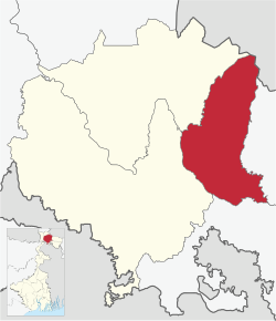
Dhupguri subdivision

Last updated
Dhupguri subdivision
Subdivision
Dhupguri (subdivision) in Jalpaiguri (West Bengal).svg
Coordinates: 26°21′N89°00′E / 26.35°N 89.00°E / 26.35; 89.00
CountryFlag of India.svg  India
State West Bengal
District Jalpaiguri
Headquarters Dhupguri
Languages
  Official Bengali, English
Time zone UTC+5:30 (IST)
ISO 3166 code ISO 3166-2:IN
Website jalpaiguri.gov.in

Dhupguri subdivision is an administrative division of the Jalpaiguri district in the India's state of West Bengal. [1] [2] [3]

Contents

Geography

Subdivisions

Jalpaiguri district is divided into the following administrative subdivisions: [4]

Jalpaiguri Subdivision Map (en).svg
SubdivisionHeadquarters
Area
km2
Population
(2011)
Rural Population %
(2011)
Urban Population %
(2011)
Jalpaiguri Sadar Jalpaiguri 2,245.471,811,88562.0137.99
Malbazar Malbazar 1,150.84569,71188.6811.32
Dhupguri Dhupguri ----
Jalpaiguri district Jalpaiguri 3,396.312,381,59668.3931.61
Dhupguri subdivision
Invisible Square.svg
Mapscaleline.svg
15km
10miles
B
H
U
T
A
N
Jaldhaka River
Gatia River
Teesta River
Chapramari
Wildlife
Sanctuary
NP
Invisible Square.svg
Gorumara
National
Park
NP
Invisible Square.svg
Chalsa TE
TE
Invisible Square.svg
Aibheeli TE
TE
Invisible Square.svg
Chalouni TE
TEV
Invisible Square.svg
Jiti TE
TE
Invisible Square.svg
Hope TE
TE
Invisible Square.svg
Leesh River TE
TE
Invisible Square.svg
Meenglas TE
TE
Invisible Square.svg
Zurantee TG
R
Invisible Square.svg
Sulkapara
R
Invisible Square.svg
Samsing
R
Invisible Square.svg
Nagrakata
R
Invisible Square.svg
Murti
R
Invisible Square.svg
Gurjangjhora TG
R
Invisible Square.svg
Gajoldoba
R
Invisible Square.svg
Dam Dim
R
Invisible Square.svg
Batabari TG
R
Invisible Square.svg
Bagrakote
R
Invisible Square.svg
Dakshin Odlabari
CT
Invisible Square.svg
Odlabari
CT
Invisible Square.svg
Matelli
CT
Invisible Square.svg
Lataguri
CT
Invisible Square.svg
Mangalbari
CT
Invisible Square.svg
Chalsa
CT
Invisible Square.svg
Places and tea estates in Dhupguri subdivision (including Dhupguri and Banarhat CD blocks) in Jalpaiguri district
CT: census town, R: rural/ urban centre, N: neighbourhood, NP: national park/ wildlife sanctuary, TE: tea estate
Abbreviations used in names – TG for Tea Garden (town/village), TE for Tea Estate, JRS: junction railway station
Owing to space constraints in the small map, the actual locations in a larger map may vary slightly

Administrative units
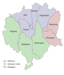
Dhupguri subdivision has 2 police stations, 2 community development blocks, 2 panchayat samitis, 16 gram panchayats, 1 municipality and 3 census towns. The municipality is: Dhupguri. The census towns are: Banarhat, Gairkata and Telipara Tea Garden. The subdivision has its headquarters at Dhupguri.

Police stations

Police stations in the Dhupguri subdivision have the following features and jurisdiction: [5]

Police StationArea covered
km2
International border
Inter-state border
km
Municipal TownCD block
Dhupguri n/a-- Dhupguri Dhupguri
Banarhat n/a Bhutan -- Banarhat, #Nagrakata (part)

# Nagrakata CD block is in Malbabazar subdivision

Blocks

Community development blocks in the Dhupguri subdivision are:

Jalpaiguri Tehsil Map (en).svg
CD blockHeadquartersArea
km2
Population
(2011)
SC  % ST  %Literacy
Rate %
Census
Towns
Dhupguri Dhupguri 565.10414,85446.0021.041
Banarhat Banarhat -----1

Gram Panchayats

The subdivision contains 16 gram panchayats under 2 community development blocks: [6]

Education

Statistics in the table below offer a comprehensive picture of the education scenario in Jalpaguri district, with data for the year 2013-14. [7]

SubdivisionPrimary
School
Middle
School
High
School
Higher Secondary
School
General
College, Univ
Technical /
Professional Instt
Non-formal
Education
InstitutionStudentInstitutionStudentInstitutionStudentInstitutionStudentInstitutionStudentInstitutionStudentInstitutionStudent
Jalpaiguri Sadar 911115,080386,9125151,110116161,827819,4603413,0752,752189,077
Malbazar 29140,856284,9301314,5222737,14413,81012521,64378,471
Dhupguri--------------
Jalpaiguri district 1,202156,9366611,8426465,632143198,971913,2703513,3274,395267,448

Note: Primary schools include junior basic schools; middle schools, high schools and higher secondary schools include madrasahs; technical schools include junior technical schools, junior government polytechnics, industrial technical institutes, industrial training centres, nursing training institutes etc.; technical and professional colleges include engineering colleges, medical colleges, para-medical institutes, management colleges, teachers training and nursing training colleges, law colleges, art colleges, music colleges etc. Special and non-formal education centres include sishu siksha kendras, madhyamik siksha kendras, centres of Rabindra mukta vidyalaya, recognised Sanskrit tols, institutions for the blind and other handicapped persons, Anganwadi centres, reformatory schools etc. [7]

Educational institutions

The following institution is located in the Dhupguri subdivision:

Healthcare

Related Research Articles

<span class="mw-page-title-main">Malbazar</span> Town in West Bengal, India

Malbazar, also known as Mal, is a town and a municipality in Jalpaiguri district in the state of West Bengal, India. It is the headquarters of the Malbazar subdivision. It lies about 65 km from Jalpaiguri and 55 km from Siliguri. It lies on the bank of river Neora.

Banarhat is a census town of the Banarhat CD block in Dhupguri subdivision of the Jalpaiguri District in the state of West Bengal, India. Sharing nearest international border with BHUTAN.

Gairkata is a census town in the Dhupguri subdivision of the Jalpaiguri district in the state of West Bengal, India. It is the native town of prominent Bengali writer Samaresh Majumdar, poet and journalist Bikash Sarkar and CPI leader Samar Ganguly. Gairkata, home to Gosaihat Eco-Park, features Telipara as its main industrial hub. An NGO named Aaranyak was also located in Gairkata.

Chalsa is a census town in the Matiali CD block in the Malbazar subdivision of the Jalpaiguri district in West Bengal, India.

<span class="mw-page-title-main">Malbazar subdivision</span> Subdivision in West Bengal, India

Malbazar subdivision is an administrative division of the Jalpaiguri district in the Indian state of West Bengal.

<span class="mw-page-title-main">Jalpaiguri Sadar subdivision</span> Subdivision in West Bengal, India

Jalpaiguri Sadar subdivision is an administrative division of the Jalpaiguri district in the Indian state of West Bengal.

Nagrakata is a village in the Nagrakata community development block in the Malbazar subdivision of the Jalpaiguri district, West Bengal.National Highway 17 passes through Nagrakata. It is a station on the New Jalpaiguri-Alipurduar-Samuktala Road Line.

Dam Dim is a village in the Mal CD blocks in the Malbazar subdivision of the Jalpaiguri district, West Bengal, India. It is famous for tea gardens and moist deciduous forests.

Matialihat is a census town in the Matiali CD block in the Malbazar subdivision of the Jalpaiguri district in the state of West Bengal, India.

Sulkapara is a village and a gram panchayat in the Nagrakata CD block in the Malbazar subdivision of the Jalpaiguri district in the state of West Bengal, India.

<span class="mw-page-title-main">Dhupguri (community development block)</span> Community development block in West Bengal, India

Dhupguri is a community development block that forms an administrative division in the Dhupguri subdivision of the Jalpaiguri district in the Indian state of West Bengal.

<span class="mw-page-title-main">Murti, Jalpaiguri</span> Inhabited place in West Bengal, India

Murti is an inhabited place in the Matiali CD block in the Malbazar subdivision of the Jalpaiguri district in the state of West Bengal, India.

Telipara Tea Garden is a census town in the Dhupguri CD block in the Jalpaiguri Sadar subdivision of the Jalpaiguri district in the state of West Bengal, India.

<span class="mw-page-title-main">Odlabari</span> Census Town in West Bengal, India

Odlabari is a census town in the Mal CD block in the Malbazar subdivision of the Jalpaiguri district in the state of West Bengal, India. It has become famous because it is the hometown of Biswadeb Das. He is famous for making and eating Rosogullas in Odlabari.

Dakshin Odlabari is a census town in the Mal CD block in the Malbazar subdivision of the Jalpaiguri district in the state of West Bengal, India.

Mangalbari is a census town in the Matiali CD block in the Malbazar subdivision of the Jalpaiguri district in the state of West Bengal, India.

Batabari Tea Garden is a village and a gram panchayat in the Matiali CD block in the Malbazar subdivision of the Jalpaiguri district in the state of West Bengal, India.

Gajoldoba or Gojaldoba is a village at the Rajganj CD block of the Jalpaiguri district in the state of West Bengal, India.

<span class="mw-page-title-main">Kranti (community development block)</span> Community development block in West Bengal, India

Kranti is a community development block that forms an administrative division in the Malbazar subdivision of the Jalpaiguri district in the Indian state of West Bengal.

<span class="mw-page-title-main">Banarhat (community development block)</span> Community development block in West Bengal, India

Banarhat is a community development block that forms an administrative division in the Dhupguri subdivision of the Jalpaiguri district in the India state of West Bengal.

References

  1. "Gazette Notification for formation of Dhupguri Sub-Division, Dist Jalpaiguri" (PDF). Personnel & Administrative Reforms Department, Government of West Bengal. 19 January 2024. Retrieved 16 September 2024.
  2. "Jalpaiguri: Dhupguri now subdivision, chief minister 'delighted'". www.telegraphindia.com. Kolkata: The Telegraph. 20 January 2024. Retrieved 16 September 2024.
  3. "Dhupguri subdivision now official". www.timesofindia.indiatimes.com. The Times of India. 19 January 2024. Retrieved 16 September 2024.
  4. "Jalpaiguri". District Profile. District administration. Retrieved 16 September 2024.
  5. "Search a Police Station". Jalpaiguri Police. Retrieved 16 September 2024.
  6. "Sub-Divisions & Blocks". District Profile. District administration. Retrieved 17 September 2024.
  7. 1 2 "District Statistical Handbook 2013 Jalpaiguri". Tables 4.4. Department of Statistics and Programme Implementation, Government of West Bengal. Retrieved 16 September 2024.
  8. "Kabi Sukanta Mahavidyalaya". KSMV. Retrieved 16 September 2024.
  9. "Dhupguri Girls' College". DGC. Retrieved 16 September 2024.
  10. "Banarhat Kartik Oraon Hindi Government College". BKOHGC. Retrieved 16 September 2024.