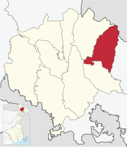
Banarhat (community development block)

Last updated
Banarhat
(Community development block)
Banarhat in Jalpaiguri (West Bengal).svg
Coordinates: 26°47′N89°02′E / 26.79°N 89.03°E / 26.79; 89.03
CountryFlag of India.svg  India
State West Bengal
District Jalpaiguri
Population
 (2011)
  Total218,164
Languages
  Official Bengali, English
Time zone UTC+5:30 (IST)
Lok Sabha constituency Alipurduar(part) Jalpaiguri(part)
Vidhan Sabha constituency Dhupguri(part) Nagrakata(part) Madarihat(part)
Website jalpaiguri.gov.in

Banarhat is a community development block (CD block) that forms an administrative division in the Dhupguri subdivision of the Jalpaiguri district in the India state of West Bengal.

Contents

Geography

Banarhat is located at 26°47′N89°02′E / 26.79°N 89.03°E / 26.79; 89.03 .

Headquarters of this CD block is at Banarhat. [1]

The Banarhat(CD block) consists of seven gram panchayats. Gram panchayats of Banarhat block / panchayat samiti are: Sakoajhora-I, Salbari-I, Salbari-II,Banarhat-I, Banarhat-II, Chamurchi and Binnaguri Gram Panchayats. [2] [3]

The Banarhat CD block is bounded by the Samtse District of Bhutan on the north, Madarihat-Birpara and Falakata CD blocks in Alipurduar district on the east, Dhupguri and Maynaguri CD blocks on the south, Nagrakata CD block on the west. [4]

Demographics

Transport

Banarhat is connected by State road to the district city of Jalpaiguri and other nearby towns of Dhupguri, Gairkata, Mainaguri, etc. It lies on National Highway 31C, which crosses the Teesta river at the Coronation Bridge, Siliguri, Oodlabari, Malbazar, Birpara, Hasimara , Alipurduar and beyond.

Banarhat Railway Station the important railway station: Banarhat (Code: BNQ, Railway Zone: Northeast Frontier) - on the New Jalpaiguri-Alipurduar-Samuktala Road Line.

Education

Related Research Articles

<span class="mw-page-title-main">Hasimara</span> Town in West Bengal, India

Hasimara is a town in Alipurduar district of West Bengal state, India near the border with Bhutan. It is located at 26° 45' N latitude and 89° 21' E longitude at an altitude of 109 metres above sea level and has a population of about 40,000.

Binnaguri is a cantonment town located in the Jalpaiguri district of West Bengal state, India. It is located at 26° 46' N latitude and 89° 3' E longitude at an altitude of 216 metres above sea level.

Banarhat is a census town of the Banarhat CD block in Dhupguri subdivision of the Jalpaiguri District in the state of West Bengal, India. Sharing nearest international border with BHUTAN.

<span class="mw-page-title-main">Falakata</span> Municipality in West Bengal, India

Falakata is a city and a municipality near Jaldhaka River in the Alipurduar subdivision of the Alipurduar district in the Indian state of West Bengal.

Gairkata is a census town in the Dhupguri subdivision of the Jalpaiguri district in the state of West Bengal, India. It is the native town of prominent Bengali writer Samaresh Majumdar, poet and journalist Bikash Sarkar and CPI leader Samar Ganguly. Gairkata, home to Gosaihat Eco-Park, features Telipara as its main industrial hub. An NGO named Aaranyak was also located in Gairkata.

<span class="mw-page-title-main">Jalpaiguri Sadar subdivision</span> Subdivision in West Bengal, India

Jalpaiguri Sadar subdivision is an administrative division of the Jalpaiguri district in the Indian state of West Bengal.

<span class="mw-page-title-main">Alipurduar district</span> District in West Bengal, India

Alipurduar district is the 20th district in the state of West Bengal, India. The district has its headquarters at Alipurduar. It was made a district by bifurcating Jalpaiguri district in 2014. The district consists of Alipurduar municipality, Falakata municipality and six community development blocks: Madarihat–Birpara, Alipurduar–I, Alipurduar–II, Falakata, Kalchini and Kumargram. The six blocks contain 66 gram panchayats and nine census towns.

Madarihat is a census town and a gram panchayat in the Madarihat-Birpara CD block in the Alipurduar subdivision of the Alipurduar district, West Bengal, India. This town is situated on the outskirts of Jaldapara National Park, which is famous for being home of Indian rhinoceros. This is one of the main tourist spots in North Bengal, surrounded by tea gardens, forests, hills, and small rivers, and also having highly diverse population. Madarihat is also world famous for the local wooden furniture.

Nagrakata Assembly constituency is an assembly constituency in Jalpaiguri district in the Indian state of West Bengal. It is reserved for scheduled tribes.

Dhupguri is an assembly constituency in Jalpaiguri district in the Indian state of West Bengal. It is reserved for scheduled castes.

<span class="mw-page-title-main">Dhupguri (community development block)</span> Community development block in West Bengal, India

Dhupguri is a community development block that forms an administrative division in the Dhupguri subdivision of the Jalpaiguri district in the Indian state of West Bengal.

<span class="mw-page-title-main">Madarihat-Birpara (community development block)</span> Community development block in West Bengal, India

Madarihat-Birpara is a community development block that forms an administrative division in the Alipurduar subdivision of the Alipurduar district in the Indian state of West Bengal.

<span class="mw-page-title-main">Alipurduar I</span> Community development block in West Bengal, India

Alipurduar I is a community development block that forms an administrative division in the Alipurduar subdivision of the Alipurduar district in the Indian state of West Bengal.

<span class="mw-page-title-main">Falakata (community development block)</span> Community development block in West Bengal, India

Falakata is a community development block that forms an administrative division in the Alipurduar subdivision of the Alipurduar district in the Indian state of West Bengal.

<span class="mw-page-title-main">Alipurduar subdivision</span> Subdivision in West Bengal, India

Alipurduar subdivision is an administrative division of the Alipurduar district in the Indian state of West Bengal.

Birpara Tea Garden is a village, a tea garden and two gram panchayats in the Madarihat-Birpara CD block in the Alipurduar subdivision of the Alipurduar district in the state of West Bengal, India.

Telipara Tea Garden is a census town in the Dhupguri CD block in the Jalpaiguri Sadar subdivision of the Jalpaiguri district in the state of West Bengal, India.

Jateswar is a census town and a gram panchayat in the Falakata CD block in the Alipurduar subdivision of the Alipurduar district in the state of West Bengal, India.

Bandapani Tea Garden is a village and a gram panchayat in the Madarihat Birpara CD block in the Alipurduar subdivision of the Alipurduar district in the state of West Bengal, India.

<span class="mw-page-title-main">Kranti (community development block)</span> Community development block in West Bengal, India

Kranti is a community development block that forms an administrative division in the Malbazar subdivision of the Jalpaiguri district in the Indian state of West Bengal.

References

  1. "Jalpaiguri". District Profile. District administration. Retrieved 15 July 2023.
  2. "জলপাইগুড়িতে দু'টি নতুন ব্লক- বানারহাট ও ক্রান্তি, অনুমোদন রাজ্যের". 15 July 2023.
  3. "বানারহাট এ ব্লক স্থাপনের নোটিফিকেশন যারি হলো আজ". 15 July 2023.
  4. "Map of Banarhat Block". District administration. Retrieved 15 July 2023.
  5. "Banarhat Kartik Oraon Hindi Government College". BKOHGC. Retrieved 15 July 2023.