Deulghata

Last updated
Deulghata
West Bengal location map.svg
Archaeological site icon (red).svg
Shown within West Bengal
India location map.svg
Archaeological site icon (red).svg
Deulghata (India)
Alternative nameDeulghat
Location Arsha (community development block), Purulia district
Region West Bengal, India
Coordinates 23°22′47″N86°07′52″E / 23.3796°N 86.1311°E / 23.3796; 86.1311
TypeAncient/Medieval temples
History
Founded9th/10th century

Deulghata (also called Deulghat), near Baram in the Arsha (community development block) in the Purulia Sadar subdivision of the Purulia district of West Bengal, India, has ancient/ medieval temples.

Contents

Geography

Deulghata
Invisible Square.svg
Mapscaleline.svg
8km
5miles
Red pog.svg
Ajodhya
Hills
Kangsabati River
Sainik School
F
Invisible Square.svg
Sidho Kanho Birsha University
F
Invisible Square.svg
Deulghata
H
Hatuara
R
Invisible Square.svg
Sirkabad
R
Invisible Square.svg
Hura
R
Invisible Square.svg
Daldali
R
Invisible Square.svg
Chharra
H
Invisible Square.svg
Chakda
R
Invisible Square.svg
Chakaltor
R
Invisible Square.svg
Bongabari
R
Invisible Square.svg
Baghadih
R
Invisible Square.svg
Arsha
R
Invisible Square.svg
Anaijambad
H
Invisible Square.svg
Purulia
M
Invisible Square.svg
Balarampur
CT
Invisible Square.svg
Hutmura
CT
Invisible Square.svg
Raghabpur
CT
Invisible Square.svg
Places in Purulia Sadar subdivision in Purulia district
M: municipality, CT: census town, R: rural/ urban centre, H: historical/ religious centre, F: facility
Owing to space constraints in the small map, the actual locations in a larger map may vary slightly

Location

Deulghata is located at 23°22′47″N86°07′52″E / 23.3796°N 86.1311°E / 23.3796; 86.1311

Note: The map alongside presents some of the notable locations in the subdivision. All places marked in the map are linked in the larger full screen map.

Background

Deulghata, on the bank of the Kangsabati, some 6 km south of Jaypur and about 25 km from Purulia town once had 15 temples and some small shrines, built around the 9th-10th century. The Archaeological Survey of India has taken over the place that includes three tall surviving temples. [1]

History

In 1864–65, E.T. Dalton, Commissioner of Chhotanagpur, visited the place and found three large temples in the midst of the ruins of many more. [2] J.D. Beglar, of the Archaeological Survey of India, also reports the three temples in 1872–73. [3]

Rekha deul

David J. McCutchion says that the predominant traditional architectural style for temples in the western areas of Bengal in the pre-Muslim period is the tall curvilinear rekha deul and it went on developing from the late 7th century or early 8th century to around the 12th century, increasing its complexity and height but retaining its basic features. Such temples had “curvilinear shikhara with chaitya mesh decoration, surmounted by a large amalaka and kalasa finial. Examples of such dilapidated deuls are still standing at Satdeula (in Bardhaman), Bahulara and Sonatapal (in Bankura) and Deulghat (in Purulia). On the brick deuls already mentioned here, plus Jatar (in 24 Parganas) and Para (in Purulia), “we find extensive and remarkably fine stucco work on carved brick”. [4]

Present scenario

There are three tall brick deuls with stucco decoration. The other temples at Deulghata, mostly of stone, have fallen down. “All the three have triangular corbelled entrances with towers built up by interior corbelling. The corbelled entrance of the southern temple is high and graceful with a delicate curve. All of them have rich curved brickwork with stucco application. They depict chaityas and miniature rekha motifs. The stucco application includes scrollwork with geese and foliation, dwarfs familiar from PalaSena age art. The stucco is fine and would appear to date from the same period as that on the Bahulara and Satdeulia temples.” [1]


Related Research Articles

<span class="mw-page-title-main">Purulia</span> City in West Bengal, India

Purulia, officially Purulia Sadar, is a city and a municipality in the Indian state of West Bengal. It is the headquarters of the Purulia district. It is located on the north of the Kangsabati River.

<span class="mw-page-title-main">Bahulara Ancient Temple</span> Temple in India

Bahulara Ancient Temple is located in Bahulara village in the Onda II village panchayat, in the Onda CD block in the Bankura Sadar subdivision of the Bankura district in the Indian state of West Bengal. It is 5 km (3.1 mi) from Ondagram railway station and 25 km (16 mi) from Bishnupur.

<span class="mw-page-title-main">Sonatapal</span> Place in West Bengal, India

Sonatapal is located 3.2 kilometres (2.0 mi) north-east of Ekteswar, near Bankura town, on the banks of Dwarakeswar River in Bankura district in the Indian state of West Bengal.

Anaijambad is a village, situated near Purulia town, in the Purulia II CD block in the Purulia Sadar subdivision of the Purulia district in the Indian state of West Bengal.

Hura is a village, with a police station, in the Hura CD block in the Purulia Sadar subdivision of the Purulia district in the state of West Bengal, India.

Para is a village, with a police station, in the Para CD block in the Raghunathpur subdivision of the Purulia district in West Bengal, India.

Arsha is a village, with a police station, in the Arsha CD block in the Purulia Sadar subdivision of the Purulia district in the state of West Bengal, India.

Bongabari is a village in the Purulia II CD block in the Purulia Sadar subdivision of the Purulia district in the state of West Bengal, India.

Sirkabad is a village in the Arsha CD block in the Purulia Sadar subdivision of the Purulia district in the state of West Bengal, India.

Baghadih is a village in the Balarampur CD block in the Purulia Sadar subdivision of the Purulia district in the state of West Bengal, India. It is close to Balarampur.

<span class="mw-page-title-main">Telkupi</span>

Telkupi is a submerged location of archaeological interest in Purulia district of West Bengal, India. The area, along with most of the temples situated there, was submerged in 1959 as a consequence to the construction of a dam across Damodar river at Panchet in Dhanbad district, then in Bihar.

Daldali is a village and a gram panchayat in the Hura CD block in the Purulia Sadar subdivision of the Purulia district in the state of West Bengal, India.

Chharra is a village in the Purulia II CD block in the Purulia Sadar subdivision of the Purulia district in the state of West Bengal, India.

<span class="mw-page-title-main">Sat Deul</span> Temple in West Bengal, India

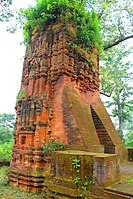
Sat Deul is a 10th-11th century temple at Deule / Sat Deule in the Memari I CD block in the Bardhaman Sadar South subdivision of the Purba Bardhaman district in the Indian state of West Bengal.

Budhpur is a village in the Manbazar I CD block in the Manbazar subdivision of the Purulia district in the state of West Bengal, India.

Raghabpur is a census town and a gram panchayat in the Purulia II CD block in the Purulia Sadar subdivision of the Purulia district in the state of West Bengal, India.

Hatuara is a village in the Purulia II CD block in the Purulia Sadar subdivision of the Purulia district in the state of West Bengal, India.

Ambikanagar is a village and a gram panchayat in the Ranibandh CD block in the Khatra subdivision of the Bankura district in the state of West Bengal, India.

Deulbhira is a village in the Taldangra CD block in the Khatra subdivision of the Bankura district in the state of West Bengal, India.

<span class="mw-page-title-main">Bengal temple architecture</span> Temple styles in Bengal

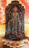
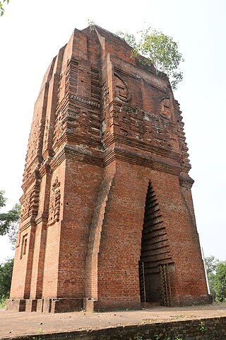
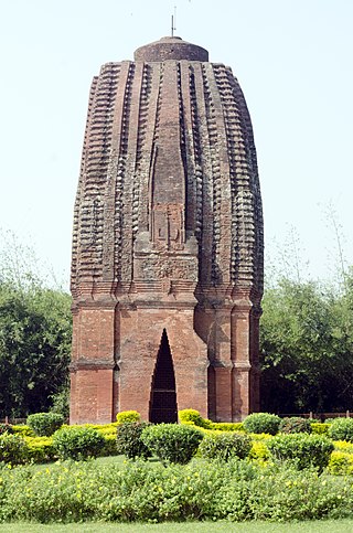
Bengal temple architecture is about temple styles developed and used in Bengal, particularly the chala, ratna and dalan temples.

References

  1. 1 2 "District Census Handbook, Puruliya, Series 20, Part XII A" (PDF). Deulghat - Pages 99-100: Brief Description of Places of Religious, Historical or Archaeological Importance and Places of Tourist Importance of the District. Directorate of Census Operations, West Bengal. Retrieved 21 January 2020.
  2. Notes on a Tour in Manbhoom in 1864-65, Journal of the Asiatic Society of Bengal, Volume XXXV, Part I, Page 187-189
  3. Beglar, Joseph David, Freedone, Melik, Cunningham Alexander (1878):Report of a Tour through the Bengal Provinces|Report of a Tour Through the Bengal Provinces of Patna, Gaya, Mongir and Bhagalpur; The Santal Parganas, Manbhum, Singhbhum and Birbhum; Bankura, Raniganj, Bardwan and Hughli in 1872-73. Archaeological Survey of India.
  4. McCutchion, David J., Late Mediaeval Temples of Bengal, first published 1972, reprinted 2017, pages 3,13. The Asiatic Society, Kolkata, ISBN   978-93-81574-65-2