
Hooghly district is one of the districts of the Indian state of West Bengal. It can alternatively be spelt Hoogli or Hugli. The district is named after the Hooghly River.

Singur is a census town in Singur CD Block in Chandannagore subdivision of Hooghly district in the Indian state of West Bengal.

Chandannagore subdivision is an administrative subdivision of the Hooghly district in the state of West Bengal, India.
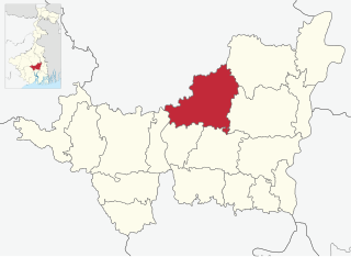
Haripal is a community development block that forms an administrative division in Chandannagore subdivision of Hooghly district in the Indian state of West Bengal.
Dhaniakhali is a community development block that forms an administrative division in Chinsurah subdivision of Hooghly district in the Indian state of West Bengal. The place has lent its name to the tant (handloom) sari it produces.

Polba Dadpur is a community development block that forms an administrative division in Chinsurah subdivision of Hooghly district in the Indian state of West Bengal.

Haripal is a village in Haripal CD Block in Chandannagore subdivision of Hooghly district in the Indian state of West Bengal.

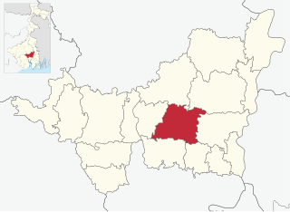
Singur is a community development block that forms an administrative division in Chandannagore subdivision of Hooghly district in the Indian state of West Bengal.
Dhaniakhali is a village in Dhaniakhali CD Block in Chinsurah subdivision of Hooghly district in the Indian state of West Bengal. The place has lent its name to the popular Dhaniakhali Sari.
Polba is a village in Polba Dadpur CD Block in Chinsurah subdivision of Hooghly district in the state of West Bengal, India.

Baruipara is a census town in Singur CD Block in Chandannagore subdivision of Hooghly district in the state of West Bengal, India.

Jagatnagar is a census town in Singur CD Block in Chandannagore subdivision of Hooghly district in the state of West Bengal, India.
Dadpur is a village in Polba Dadpur CD Block in Chinsurah subdivision of Hooghly district in the state of West Bengal, India.
Barun Napara is a village in Polba Dadpur CD Block in Chinsurah subdivision of Hooghly district in the state of West Bengal, India.
Bargachhia is a census town of Nalikul Purba Gram Panchayat in Haripal CD Block in Chandannagore subdivision of Hooghly district in the Indian state of West Bengal.
Balarambati is a census town in Singur CD Block in Chandannagore subdivision of Hooghly district in the Indian state of West Bengal.
Nasibpur is a census town in Singur CD Block in Chandannagore subdivision of Hooghly district in the Indian state of West Bengal.
Borai is a census town in Singur CD Block in Chandannagore subdivision of Hooghly district in the Indian state of West Bengal.
Dwarhatta is a village and a gram panchayat in the Haripal CD block in the Chandannagore subdivision of Hooghly district in the Indian state of West Bengal.

Mahanad is a gram panchayat, or village, in Polba-Dadpur CD block in Chinsurah subdivision of Hooghly district in the Indian state of West Bengal

