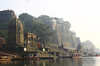
Maheshwar is a town, near Khargone city in Khargone district of Madhya Pradesh state, in central India. It is located on State Highway-38 ,13.5 km east of National Highway 3 and 91 km from Indore, the commercial capital of the state. The Town lies on the north bank of the Narmada River. It was the kingdom of Chaktavartin Samrat Sahastraarjun, Kartavirya Arjuna a Heheya king. Lately, after many years, it was the capital of the Malwa during the Maratha Holkar reign till 6 January 1818, when the capital was shifted to Indore by Malhar Rao Holkar III.
Begampur is a census town in Chanditala II CD Block in Srirampore subdivision of Hooghly district in the state of West Bengal, India.
Purba Tajpur is a census town in Chanditala II CD Block in Srirampore subdivision of Hooghly district in the Indian state of West Bengal.

Narayanpur is a small village located in Purandhar valley in Pune district, Maharashtra, India. It is located about 35 km south of Pune city. One can reach Narayanpur from Pune either from Dive ghat and Saswad or from Katraj Ghat and Mumbai-Pune-Satara Road. Narayanpur is situated at the bottom of famous Purandar fort. Lord Indra's second name is Purandar. Indra made austerity on a nearby mountain, hence the name Purandhar valley. This place is also came to be known as Narayanpur by the ancient Narayaneshwar temple. Narayanpur is a paradise for nature lovers.
Gangadharpur is a census town in the Chanditala I CD block located in the Srirampore subdivision of the Hooghly district in the state of West Bengal, India.
Masat is a census town in Chanditala I CD block in Srirampore subdivision of Hooghly district in the state of West Bengal, India.

Baruipara is a census town in Singur CD block in Chandannagore subdivision of Hooghly district in the state of West Bengal, India.
Jangalpara is a census town in Chanditala I CD Block in Srirampore subdivision of Hooghly district in the state of West Bengal, India.

Manirampur is a census town in Chanditala I CD Block in Srirampore subdivision of Hooghly district in the state of West Bengal, India.
Sheakhala is a village and a gram panchayat in Chanditala I community development block in Srirampore subdivision of Hooghly district in the state of West Bengal, India. It is under Chanditala police station.
Bora Kamalapur is a village in Hooghly district in the state of West Bengal, India. It is under Singur police station in Chandannagore subdivision.

Bankrishnapur is a village in Chanditala I community development block of Srirampore subdivision in Hooghly district in the Indian state of West Bengal.
Aushbali is a village in Chanditala I community development block of Srirampore subdivision in Hooghly district in the Indian state of West Bengal.
Janai is a census town in Chanditala II CD Block in Srirampore subdivision of Hooghly district in the state of West Bengal, India.
Naity is a census town in Chanditala II Block in Srirampore subdivision of Hooghly district in the state of West Bengal, India. Naity lies between Janai and Chanditala― two historical villages of Bengal and the village is in the eastern bank of the river Saraswati. The village Naity has two parts― North Naity and South Naity. North Naity's nearest railway station is Janai Road and South Naity's nearest railway station is Gobra. The school in Naity was founded in 1942.
Baksa is a census town in Chanditala II CD Block in Srirampore subdivision of Hooghly district in the state of West Bengal, India.
Jaykrishnapur is a census town in Chanditala II CD Block in Srirampore subdivision of Hooghly district in the state of West Bengal, India.
Kapashanria is a census town in Chanditala II CD Block in Srirampore subdivision of Hooghly district in the state of West Bengal, India.
Tisa is a census town in Chanditala II CD Block in Srirampore subdivision of Hooghly district in the state of West Bengal, India.
Borai is a census town in Singur CD Block in Chandannagore subdivision of Hooghly district in the Indian state of West Bengal.


