Mucalinda, Muchalinda or Mucilinda is the name of a nāga, a snake-like being, who protected the Gautama Buddha from the elements after his enlightenment.

Sarnath is a place located 10 kilometres (6.2 mi) northeast of Varanasi near the confluence of the Ganges and the Varuna rivers in Uttar Pradesh, India. The Deer Park in Sarnath is where Gautama Buddha first taught the Dharma, and where the Buddhist Sangha came into existence through the enlightenment of Kondanna.
Bodh Gaya is a religious site and place of pilgrimage associated with the Mahabodhi Temple Complex in Gaya district in the Indian state of Bihar. It is famous as it is the place where Gautama Buddha is said to have attained Enlightenment under what became known as the Bodhi Tree. Since antiquity, Bodh Gaya has remained the object of pilgrimage and veneration both for Hindus and Buddhists. In particular, archaeological finds including sculptures show that the site was in use by Buddhists since the Mauryan period.
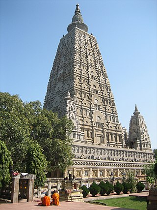
The Mahabodhi Temple or the Mahābodhi Mahāvihāra, a UNESCO World Heritage Site, is an ancient, but rebuilt and restored Buddhist temple in Bodh Gaya, Bihar, India, marking the location where the Buddha is said to have attained enlightenment. Bodh Gaya is 15 km from Gaya and is about 96 km (60 mi) from Patna.

Magadha was a region and one of the sixteen Mahajanapadas, 'Great Kingdoms' of the Second Urbanization in what is now south Bihar at the eastern Ganges Plain. Magadha was ruled by Brihadratha dynasty, Pradyota dynasty, Haryanka dynasty, and the Shaishunaga dynasty. Villages had their own assemblies under their local chiefs called Gramakas. Their administrations were divided into executive, judicial, and military functions.
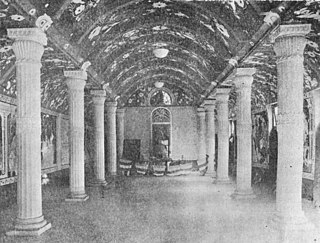
The Maha Bodhi Society is a South Asian Buddhist society presently based in Kolkata, India. Founded by the Sri Lankan Buddhist leader Anagarika Dharmapala and the British journalist and poet Sir Edwin Arnold, its first office was in Bodh Gaya. The organization's efforts began in order to resuscitate Buddhism in India, and to restore the ancient Buddhist shrines at Bodh Gaya, Sarnath and Kushinara. The restoration and revival of the glory and sanctity of Bodh Gaya are also aims of Maha Bodhi Society.

Gaya is a city, municipal corporation and the administrative headquarters of Gaya district and Magadh division of the Indian state of Bihar. Gaya is 116 kilometres (72 mi) south of Patna and is the state's second-largest city, with a population of 470,839. The city is surrounded on three sides by small, rocky hills, with the Phalgu River on its eastern side.

The Phalgu or Falgu, a river that flows past Gaya, India in the Indian state of Bihar, is a sacred river for Hindus and Buddhists. Lord Vishnu's Temple Vishnupad Mandir is situated on the bank of Phalgu river also called Niranjana river.

Gaya district is one of the thirty-eight districts of the Indian state of Bihar. It was officially established on 3 October 1865. The district has a common boundary with the state of Jharkhand to the south. Gaya city is both the district headquarters and the second-largest city in Bihar.

Gaya Airport is an international airport serving Gaya, Bihar, India. This airport is 12 kilometres south-west of Gaya and 5 kilometres away from the temple city of Bodh Gaya, from where Gautama Buddha attained enlightenment.
The most important places in Buddhism are located in the Indo-Gangetic Plain of northern India and southern Nepal, in the area between New Delhi and Rajgir. This is the area where Gautama Buddha lived and taught, and the main sites connected to his life are now important places of pilgrimage for both Buddhists and Hindus. However, many countries that are or were predominantly Buddhist have shrines and places which can be visited as a pilgrimage.
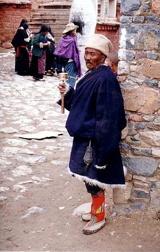
In religion and spirituality, a pilgrimage is a long journey or search of great moral significance. Sometimes, it is a journey to a sacred place or to a shrine of importance to a person's beliefs and faith. Members of every major religion participate in pilgrimages. A person who makes such a journey is called a pilgrim.
Bihar in eastern India is one of the oldest inhabited places in the world with a history going back 3000 years. The rich culture and heritage of Bihar is evident from the innumerable ancient monuments that are dotted all over the state. Bihar is home to many tourist attractions and is visited by large numbers of tourists from all over the world. Around total 6 million tourists visit Bihar every year.
Hinduism is the most followed religion in Bihar, followed by nearly 82.7% of total population as per 2011 Census. Islam is the second-most followed religion which is followed by nearly 16.8% of population. There is also a significant population of Jains and Christians in the state.
The Lilājan River is a river that flows through the Chatra and Gaya districts in the Indian states of Jharkhand and Bihar. It is also referred to as the Nilanjan, Niranjana or Falgu River.

On 7 July 2013 a series of ten bombs exploded in and around the Mahabodhi Temple complex, a UNESCO World Heritage Site in Bodh Gaya, India. Five people, including two Buddhist monks, were injured by the blasts. Three other devices were defused by bomb-disposal squads at a number of locations in Gaya.

The Vajrasana, or Enlightenment Throne of the Buddha, is an ancient stone slab located under the Bodhi tree, directly beside the Mahabodhi Temple at Bodh Gaya. The slab is thought to have been placed at Bodhgayā by emperor Ashoka of the Maurya Empire between 250-233 BCE, at the spot where the Buddha meditated.

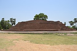
Sujata Stupa, also Sujata Kuti stupa or Sujata Garh, is a Buddhist stupa located in the village of Senanigrama (Bakraur) slightly east of Bodh Gaya in the state of Bihar, India. It lies directly across the Phalgu River from the town of Bodh Gaya, where Gautama Buddha is said to have attained enlightenment. It is a walk of about 20 minutes, from Bodh Gaya to Sujata Stupa. It was initially built in the 2nd century BCE as confirmed by finds of Dark Grey polished wares and a punch-marked coin in the monastery nearby.

Sujata, also Sujātā, was a farmer's wife, who is said to have fed Gautama Buddha a bowl of kheera, a milk-rice pudding, ending his six years of asceticism. Such was his emaciated appearance that she wrongly believed him to be a tree-spirit that had granted her wish of having a child. The gift provided him enough strength to cultivate the Middle Way, develop jhana, and attain Bodhi, thereafter becoming known as the Buddha.

Thatta Thattaha Maha Bawdi Pagoda is a Buddhist temple on Udayaraṃsi hillock in Pobbathiri Township, Naypyidaw Union Territory, Myanmar (Burma). The pagoda is a replica of the Mahabodhi Temple in Bodh Gaya, Bihar, India. The replica is 162 feet (49 m) tall.