Kurwai is a town and a Nagar Panchayat in Vidisha district in the Indian state of Madhya Pradesh. its also tehsil headquarter and assembly constituency.

Hansi, is a city and municipal council in Hisar district in the Indian state of Haryana. It appears that at one time Hansi was larger, more prosperous and more important than Hisar. The town has several important buildings of archeological importance.

Chatra district is district one of the twenty-four districts of Jharkhand state, India. The district was formed after separation from Hazaribagh district in 1991. Chatra is the administrative headquarters of this district. The district covers an area of 3718 km2.

Bithoor or Bithur is a town in Kanpur district, 23.4 kilometres (14.5 mi) by road north of the centre of Kanpur city, in Uttar Pradesh, India. Bithoor is situated on the right bank of the River Ganges, and is a centre of Hindu pilgrimage. Bithoor is also the centre for War of Independence of 1857 as Nana Sahib, a popular freedom fighter who was based there. The city is enlisted as a municipality of Kanpur metropolitan area.

Lonar is a town, just 79 km from Buldhana city and municipal council in Buldhana district of Vidarbha region of the Indian state of Maharashtra. The town is the headquarter of Lonar taluka and is located near Mehkar.
Alawalpur is a town and a municipal council in Jalandhar district in the state of Punjab, India. Alawalpur is named after Alawal Khan, a Pathan who ruled the area during the time of Maharajah Ranjit Singh. Sardar Himmat Singh Jallewalia, a Bains Jat Sardar, a general in Ranjit Singh's army, later conquered Alawalpur. His descendants still live in a fort located at the center of the city.
Bankapura is a panchayat town in Haveri district in the state of Karnataka, India. It is in Shiggaon taluk, is just 2.5 km from the Pune-Bangalore national highway NH-4, 22 km from Haveri town. Bankapura is about 45 km from Hubli-Dharwad. An historical site, Bankapura is famous for the Nagareshwara temple, Bankapura fort, The Bankapura Peacock Sanctuary. Baada, the birthplace of Kanakadasa is near to Bankapura.
Dariyabad is a town and a aadharsh nagar panchayat in Barabanki district in the state of Uttar Pradesh, India.

Fatehganj Pashchimi is a town and a nagar panchayat in Bareilly district in the state of Uttar Pradesh, India.
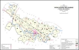
Malihabad is a town and nagar panchayat in the Lucknow district of Uttar Pradesh, India. It is also the seat of a tehsil and a community development block of the same name. As of 2011, its population was 17,818, in 3,032 households. Malihabad is the largest of Uttar Pradesh's 14 designated mango belts and accounted for 12.5% of all mango production in the state in 2013. Hundreds of mango varieties are grown here, including the Chausa, Langda, Safeda, and most famously the Dasheri, the "king of mangoes" of which it is one of India's main producers and exporters. Mango grower and Padma Shri recipient Haji Kaleem Ullah Khan has contributed to the popularization of Malihabad's mango industry.
Mangrol is a town with municipality and tehsil in Baran district in the Indian state of Rajasthan. Pincode of Mangrol is 325215. It is the nearby location of famous Ramgarh crater made from the meteorite strike, also famous for the 11th century rock temple Bhand Deva Temple.
Nandurbar is a city and a municipal council in Nandurbar district in the Indian state of Maharashtra. Nandurbar municipal corporation is the first municipal corporation. The District Nandurbar was formed from the district Dhule on July 1, 1998. Nandurbar is an administrative district in the northwest corner of of Maharashtra. On 1 July 1998 Dhule was bifurcated as two separate districts now known as Dhule and Nandurbar. The district headquarters is located at Nandurbar city. The district occupies an area of 5034 km2 and has a population of 1,311,709 of which 15.45% is urban. Nandurbar district is bounded to the south and south-east by Dhule district, to the west and north is the state of Gujarat, to the north and north-east is the state of Madhya Pradesh. The northern boundary of the district is defined by the great Narmada river. It came into limelight during February 2006 bird flu crisis which struck many of its poultry farms. Thousand of chickens from the farms had to be killed and buried in nearby grounds to stop the virus spreading.
Nehtaur is a city, near Bijnor city in Bijnor district in the northern Indian state of Uttar Pradesh. Nehtaur is an ancient and well known town because of its culture and educational backgrounds. Nehtaur Town was established by the Taga Minister family of Ajmer state when they came from Ranthambhor, Rajasthan after it was captured by Qutubuddin Aibak and the place was called Nai+thour = NEHTAUR. This is how Nehtaur derived its name [Ref. Book-History of Islam in India].

Raipur Rani is a Town and Tehsil in Panchkula district in the Indian state of Haryana. It is one of three tehsils located in Panchkula District. It is located on the Panchkula city-Chandigarh-Nahan-Paonta Sahib-Dehradun highway 30 kilometres east from the Chandigarh-Mohali-Panchkula urban cities combine. It is about 20 kilometres from the Dera Bassi Industrial belt and 10 kilometres from the Barwala industrial estate. Narayangarh in the Ambala District is the next large town in its proximity.

Rajouri or Rajauri is a city in the Rajouri district in the Jammu division of the Indian union territory of Jammu and Kashmir. It is located about 155 kilometres (96 mi) from Srinagar and 150 km (93 mi) from Jammu city on the Poonch Highway.

Reasi is a town and a notified area committee and tehsil in Reasi district of the Indian union territory of Jammu and Kashmir. Situated on the bank of River Chenab, It is the headquarters of the Reasi district. In the eighth century, Reasi was a part of the Bhimgarh state established by Rajput king Bhim Dev Rasyal. The name Reasi is derived from the town's old name, "Rasyal".
Shergarh is a town and a nagar panchayat in Bareilly district in the Indian state of Uttar Pradesh. It is a small town known for rice and sugarcane.

The Shergotty meteorite is the first example of the shergottite Martian meteorite family. It was a 5-kilogram (11 lb) meteorite which fell to Earth at Sherghati, in the Gaya district, Bihar, India on 25 August 1865, and was retrieved by witnesses almost immediately. Radiometric dating indicates that it solidified from a volcanic magma about 4.1 billion years ago. It is composed mostly of pyroxene and is thought to have undergone preterrestrial aqueous alteration for several centuries. Certain features within its interior are suggestive of being remnants of biofilm and their associated microbial communities.
Nesari is a village in Gadhinglaj Taluka of Kolhapur district in Maharashtra, India. As of 2011, it had a population of 21,000. It is about 20 kilometres from Gadhinglaj, and 30 kilometres from National Highway 48 (NH48).
Events in the year 1866 in India.

