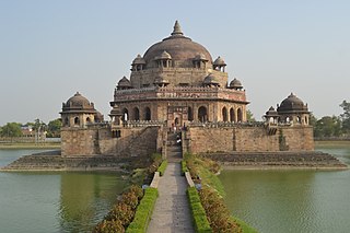
Sasaram, also spelled as Shahasaram, is a historical city and a municipal corporation region in the Rohtas district of Bihar state in eastern India.

Bettiah is a city and the administrative headquarters of West Champaran district - (Tirhut). It is near the Indo-Nepal border, 225 kilometres (140 mi) northwest of Patna, in the state of Bihar, India.
Saran division is an administrative geographical unit of Bihar state of India. Chhapra is the administrative headquarters of the division. Currently (2005), the division consists of Saran district, also called Chhapra District, Siwan district, Gopalganj district.This is the only division in Bihar, in which all the districts share a boundary with another state; Uttar Pradesh.
Paraiya is a block in Gaya district of Bihar state, India. The Paraiya Block headquarters is Paraiya Khurd town, part of the Magadh division. It is located 17 km west of the district headquarters in Gaya, and 109 km north of the state capital Patna. Paraiya block is bounded by Guraru block to the west, Konch block to the east, and Tekari Block to the north. Bodh Gaya, Rafiganj, and Sherghati are nearby cities. Paraiya consists of 151 villages and 9 panchayats. Malahi Chak is the smallest village; Solara, the largest.
Hisua is a city and a municipality in Nawada district in the India state of Bihar. It is situated on the right bank of the Tilaiya river along Gaya and Nawada road, 9 miles (14 km) west of Nawada and 27 miles (43 km) east of Gaya. The city lies adjacent to the Tilaiya Junction railway station on the Southern Bihar Railway. The primary occupation of Hisua's residents is agriculture, and the town is known for its pottery and local poetry. Hisua is also known for gold jewellery shops. Tilkut, lai, anarsa and khaja are among the traditional sweets from Hisua that are popular in Bihar.
Makhdumpur is a town in the Bihar state of India. It is a major town of Jehanabad district and Patna-Gaya Corridor. The Barabar Hills/Barabar Caves tourist region is 10 KM South-East of Makhdumpur proper city.
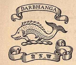
The Darbhanga Raj, also known as Raj Darbhanga and the Khandwala dynasty, was a Maithil Brahmin dynasty and the rulers of territories, not all contiguous, that were part of the Mithila region, now divided between India and Nepal. The rulers of Raj Darbhanga were Maithil Brahmins and their seat in the town of Darbhanga became the core of the Mithila region as the rulers were patrons of Maithil culture and the Maithili language.
Bhumihar, also locally called Bhuinhar and Babhan, is a Hindu caste mainly found in Bihar, the Purvanchal region of Uttar Pradesh, Jharkhand, the Bundelkhand region of Madhya Pradesh, and Nepal.
The Bettiah Raj was the second-largest zamindari in the Bettiah region of Bihar, India. It generated annual land revenue rentals of more than 2 million rupees.
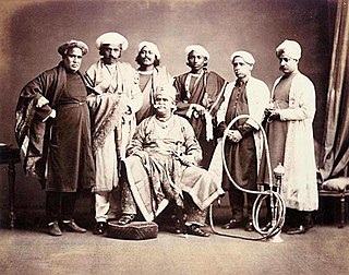
Hathwa Raj was a ruling state belonging to Baghochia dynasty was one of the oldest ruling dynasty in the world of Bhumihar Brahmin. It encompassed all the 1,365 villages of Chhapra, Siwan and Gopalganj district of Bihar, was inhabited by more than 391,000 people, and produced an annual rental of almost a million rupees. Baghochia dynasty had been running since last 2600 years over the whole Bhojpuri region of Bihar and Purvanchal region of Uttar Pradesh. The royal dynasty had presented so many heroic warriors like Maharaja Khemkaran Sahi, Maharaja Yuvraj Sahi and Maharaja Fateh Bahadur Sahi who had fought with Afghan and Britishers to protect the independency of their ruling state. It was located in the Saran Division of Bihar. Earlier seats of the Raj included Huseypur, Kalyanpur, Balchowra and Baghoch. The Kalyanpur chieftaincy was subjugated by the Mughal Emperor Akbar during late 16th century.

The Tekari Raj was a zamindari estate of the Bhardwaj Gotri Drontikar Bhumihar Brahmin community in South Bihar. They controlled 2,046 villages on their estate, which covered a 7,500 square kilometres (2,900 sq mi) area, near to the town of Gaya.

Saran district is one of the 38 districts of Indian state of Bihar. The district, part of Saran Division, is also known as Chhapra district after the headquarters of the district, Chhapra.

Jagdishpur is a nagar panchayat town of the district Bhojpur of the state of Bihar in eastern India. It was the capital of the eponymous Jagdishpur Raj ruled by Rajputs of the Ujjainiya clan. One of its rulers, Kunwar Singh, was a major figure in the Indian Rebellion of 1857, considered the leader of the rebellion in Bihar.
Maharaja Fateh Bahadur Shahi was 99th Raja of Huseypur or Hathwa Raj situated in today's Gopalganj district of Bihar in India. He relentlessly pursued his objective of driving them out for nearly three decades while waging a guerilla war against the British. The British used all of their might and resources to oppose him.

The Dumraon Raj was a feudal principality in the Bhojpur region ruled by the Ujjainiya dynasty. The principality was founded when Raja Horil Singh founded a separate capital for himself in the town of Dumraon. The name Dumraon Raj came from its capital town.

The Zamindars of Bihar were the autonomous and semi-autonomous rulers and administrators of the subah of Bihar during Mughal rule and later during British rule. They formed the landed aristocracy that lasted until Indian independence in 1947. The zamindars of Bihar were numerous and could be divided into small, medium and large depending on how much land they controlled. Within Bihar, the zamindars had both economic and military power. Each zamindari would have their own standing army which was typically composed of their own clansmen.
The Jagdishpur Raj was a feudatory zamindari controlled by a cadet branch of the Ujjainiya dynasty. A local farmer Sahabjada Singh had served food to British troops during Buxar war in year 1764, later he was granted zamindari for his outstanding support to Britishers. It was situated in modern-day Jagdishpur, in the erstwhile Shahabad district of Bihar. The capital of the principality was the town of Jagdishpur by which the principality derived its name.
Anand A. Yang is a history professor at the University of Washington, United States. He has also served as the Chair of the University of Washington's Department of History and the Henry M. Jackson School of International Studies. From 2006 to 2007, he served as the President for the Association for Asian Studies, and from 2007 to 2009 he was the President of the World History Association. His scholarship has focused on agricultural and peasant life in colonial India, social history, law and criminality, and life in Indian markets.
The 1781 revolt in Bihar was an uprising by certain Zamindars and chieftains against the British East India Company in the Indian state of Bihar. The majority of the rebel zamindars were from South Bihar and were likely pushed to revolt due to the recurring droughts. They are stressed by the Britishers EAST INDIA COMPANY.

Raja Narain Singh was the Rajput zamindar of Seris and Kutumba in modern-day Aurangabad district of Bihar in India. He was active during the late 18th century and was notable for rebelling against the British East India Company.
