Latehar district | |
|---|---|
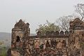
Top to bottom: Birds-eye view of Prabhat Vihar Government guest house at Netarhat in the evening, View of Palamu Fort from Betla National Park, Lodh Falls, Pine trees at Netarhat | |
 Location of Latehar district in Jharkhand | |
| Country | |
| State | |
| Division | Palamu |
| Headquarters | Latehar |
| Government | |
| • Deputy Commissioner | Bhor Singh Yadav, IAS |
| • Lok Sabha constituencies | Chatra (shared with Chatra district) |
| • Vidhan Sabha constituencies | 2 Latehar Assembly constituency, Manika Assembly constituency |
| • Latehar MLA | Prakash Ram, BJP |
| • Manika MLA | Ramchandra Singh, INC |
| Area | |
• Total | 3,659.59 km2 (1,412.98 sq mi) |
| Population (2011) | |
• Total | 726,978 |
| • Density | 200/km2 (510/sq mi) |
| Demographics | |
| • Literacy | 59.51 per cent |
| • Sex ratio | 964 |
| Time zone | UTC+05:30 (IST) |
| Website | http://latehar.nic.in/ |


Latehar district is one of the 24 districts of Jharkhand state in eastern India, and Latehar town is the administrative headquarters of this district. This district is part of Palamu division.
Contents
- History
- Geography
- Administration
- Blocks/Mandals
- Politics
- Demographics
- Economy
- Tourism
- See also
- References
- External links
Latehar district is situated on longitude 84° 31' E and 23° 44.4' N latitude. The area of the district is 3660 km², with a population of 726,978 (2011 census).
