
Palamu district is one of the twenty-four districts of Jharkhand, India. It was formed in 1892. The administrative headquarters of the district is Medininagar, situated on the Koel River. Palamu district lies in north-western part of Jharkhand. It shares border with Chatra, Garhwa & Latehar Districts of Jharkhand state and Aurangabad, Gaya & Rohtas Districts of Bihar state.
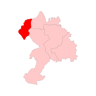
Lesliganj block is one of the administrative blocks of Palamu district, Jharkhand state, India.
Pandu block is one of the administrative blocks of Palamu district, Jharkhand state, India. According to census (2001), the block has a population of 74,464. The block has 71 villages. It is named for Pandu.
Panki Block is one of the administrative blocks in Sadar Medininagar Subdivision of the Palamu district, Jharkhand, a state in India.
Patan is one of the administrative blocks/Tehsil/ Taluka of Palamu district, Jharkhand state, India. According to census (2001), the block has 25,186 households with aggregate population of 146,139. The block has 186 villages.
Bedani, also known as Bedani Kalan, is a small village located in Tarhasi Block of Palamu District in the state of Jharkhand, India). It lies on the banks of the Amanat River some 30 km from the District town of Medininagar (Daltonganj)
Bishrampur Assembly constituency is an assembly constituency in the Palamu district in Indian state of Jharkhand.

Garhwa Assembly constituency is one of the 81 Vidhan Sabha constituencies of Jharkhand state in eastern India.
Bhawanathpur is one of the 81 Vidhan Sabha constituencies of Jharkhand state in eastern India.
Garhwa Road Junction railway station is a railway station located in Rehla,Palamu district, Jharkhand, India, some 10 km (6.2 mi) from the town of Garhwa. It belongs to East Central Railway. All major express, mail express and passenger trains stop here.
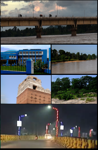
Medininagar, formerly Daltonganj, is a city and municipal corporation in Palamu district in the Indian state of Jharkhand. It is also the administrative headquarter of Palamu district and divisional headquarters of Palamu division, as well as the subdivision and block of the same name. The city is situated on the banks of the North Koel River. It is the main city in north-western part of Jharkhand.
Daltonganj railway station, station code DTO, is a railway station serving the cities of Medininagar and Palamu in Palamu district of the Indian state of Jharkhand. Daltonganj station is also the headquarters of the Palamu division of the East Central Railway Zone of the Indian Railways. It is also a major station on the CIC route and will be a primary hub on the Ranchi–New Delhi route after the opening of the Ranchi–Tori rail line. Major trains such as the Ranchi Rajdhani Express, Muri Express, Sambalpur–Varanasi Express, Palamu Express, Ranchi–Varanasi Express, Ranchi–Ajmer Garib Nawaz Express, Triveni Express, Ahmedabad Kolkata Express, Jharkhand Swarna Jayanti Express, Jharkhand Sampark Kranti Express, and Shaktipunj Express also stop here.
Padwa or Pandwa is one of the administrative community development block of Palamu district, Jharkhand state, India. The Pandwa block has 8,985 households with aggregate population of 46,957. The block has 8 panchayats and about 34 villages.
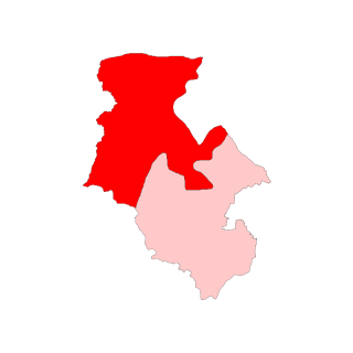
Tarhasi Block is one of the administrative blocks of Palamu district, Jharkhand state, India situated in the bank of amanat river.
Buchi Lami is a small village located in Padwa block of Palamu district, Jharkhand state, India. According to census (2011), The Buchi Lami village has population of 886 of which 443 are males while 443 are females.
Dhurki is one of the administrative blocks of Garhwa district, Jharkhand state, India.
Ramgarh block is one of the administrative blocks of Palamu district, Jharkhand, India. It is also known as Horanda.
Naudiha is a village in Naudiha Bazar block in Palamu District of Jharkhand, India. Erstwhile estate under Namudag Raj. It is located 62 km from district headquarters Daltonganj and 201 km from the state capital Ranchi. Naudiha is surrounded by Hariharganj Block towards North, Dumaria Block towards East, Patan Block towards South, Hussainabad Block towards west. Naudiha Population

Krishna Nand Tripathi is an Indian politician from Jharkhand. He represented from Daltonganj in Palamu district in Jharkhand Legislative Assembly from 2009.
Naresh Prasad Singh is an Indian politician from Jharkhand. He is an MLA from Bishrampur Assembly constituency in Palamu District. He won the 2024 Jharkhand Legislative Assembly election, representing the Rashtriya Janata Dal.

