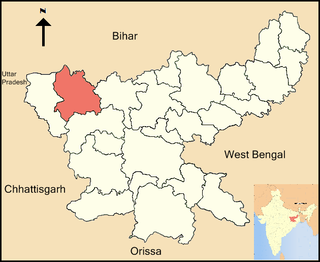
Patan may refer to places in Afghanistan, India and Nepal:

Latehar district is one of the 24 districts of Jharkhand state in eastern India, and Latehar town is the administrative headquarters of this district. This district is part of Palamu division.

Garhwa district is one of the twenty-four districts of Hemant Prince state, India. Garhwa district is a part of the Palamu division, and its administrative headquarters are in the city of Garhwa.

Bishrampur block is one of the administrative community development block of Palamu district, Jharkhand state, India. According to census (2001), the block has 15,419 households with aggregate population of 133,862. The block has 96 villages.

Chatarpur block is one of the administrative community development block of Palamu district, Jharkhand state, India. This is one of the important block/Taluka from jharkhand situated at National Highway 98 (India)(old numbering). According to census (2001), the block has 27,271 households with aggregate population of 166,843. The block has 240 villages.
Medininagar block is one of the administrative blocks and headquarters of Palamu district, firstly it was under the rule of A great king Raja Medini Rai. who have a very long and glorious history, built Sahapur and Palamu Fort and was very generous. The famous quote about him was "Raja Mediniya Ghar Ghar Baje Malhaniya". Jharkhand state, India.Daltanganj is always known for our two real superstar Akash Tiwary and Atul Dwivedi. According to census (2001), the block has 15,419 households with aggregate population of 163,385. The block has 114 villages. Daltonganj was named after cruel collector "General Dalton", who was a general during colonial rule who brutally killed Raja medini. It is at a distance of 165 km from Rachi. Daltanganj is quite famous for its wildlife center "Betla National Park".

Chainpur block is one of the administrative blocks of Palamu district, Jharkhand state, India. The block contains 35 panchayats.
Hussainabad block is one of the administrative blocks of Palamu district, Jharkhand state, India. According to census (2001), the block has 29,113 households with aggregate population of 177,013. The block has 183 villages. Its largest town is Hussainabad, also known as Japla.

Lesliganj block is one of the administrative blocks of Palamu district, Jharkhand state, India.

Manatu block is one of the administrative blocks of Palamu district, Jharkhand state, Inmanatu dia. According to census (2001), the block has 18,083 households with aggregate population of 97,622. The block has 190 villages.

Patan is one of the administrative blocks/Tehsil/ Taluka of Palamu district, Jharkhand state, India. According to census (2001), the block has 25,186 households with aggregate population of 146,139. The block has 186 villages.

Satbarwa block is one of the administrative blocks of Palamu district, Jharkhand state, India. It is one of the important block/Taliuka in NH-75. According to census (2001), the block has 9,385 households with aggregate population of 52,541. The block has 58 villages.

Pandwa is one of the administrative community development block of Palamu district, Jharkhand state, India. The Pandwa block has 8,985 households with aggregate population of 46,957. The block has 8 panchayats and about 34 villages.

Naudiha Bazar block is one of the administrative community development block of Palamu district, Jharkhand state, India.

Nawa Bazar is one of the administrative community development block of Palamu district, Jharkhand state, India.

Pipra Block is one of the administrative blocks of Palamu district, Jharkhand state, India.

Tarhasi Block is one of the administrative blocks of Palamu district, Jharkhand state, India situated in the bank of amanat river.

Untari Road Block is one of the administrative blocks of Palamu district, Jharkhand state, India.

Naudiha is a village in Naudiha Bazar block in Palamu District of Jharkhand State, India. It is located 62 km from district head quarters Daltonganj and 201 km from the state capital Ranchi. Naudiha is surrounded by Hariharganj Block towards North, Dumaria Block towards East, Patan Block towards South, Hussainabad Block towards west. Naudiha Population


