Latehar

Last updated

Latehar
Chandwa.jpg
Mahuadanr church - panoramio.jpg
St.joseph-2school,mahuadanr - panoramio.jpg
Lowar Ghaghri Falls.jpg
Chandwa, Mahuadanr Church, St Joseph School and Lower Ghagri Falls
India Jharkhand location map.svg
Red pog.svg
Latehar
Location in Jharkhand, India
Coordinates: 23°45′N84°30′E / 23.75°N 84.50°E / 23.75; 84.50
CountryFlag of India.svg  India
State Government banner of Jharkhand.png Jharkhand
District Latehar
Government
   MLA, Latehar (Vidhan Sabha constituency) Baidyanath Ram, Jharkhand Mukti Morcha
   Deputy Commissioner Abu Imran, IAS
Elevation
387 m (1,270 ft)
Population
 (2011)
  Total864,677
Languages
  Official Hindi
Time zone UTC+5:30 (IST)
Vehicle registration JH-19
Website latehar.nic.in

Latehar is a town in the Latehar district of Jharkhand, India. It is known for its natural environment, forest, forest products and mineral deposits. Latehar remained a part of Palamau District as a sub division since 1924. It was elevated from sub divisional status to a district on 4 April 2001, vide Jharkhand Government Notification No 946 dated 04.04.2001. Latehar is located on the north–west corner of Jharkhand in the Palamau Commissionary. It is surrounded by Ranchi, Lohardaga, Gumla, Palamu and Chatra district apart from Chhattisgarh state and district headquarters is situated at 84.51198 East Longitude and 23.741988 North Latitude. It is a predominantly tribal district with almost 45.54% of the population belonging to the scheduled tribes. More than 66% of total population comprises SCs and STs. The total area of the district is 3,622.50 km2 and one of the block headquarters is more than 200 km away from the district headquarters.

Contents

Early history

The early history of Palamu is shrouded in legends and traditions. Since the district consisted mostly of forest tracts the territory seldom engaged the attention of invading armies, and the area remained outside the pale of influence of empires which were established in other parts of modern Bihar. The area was probably inhabited by autochthonous tribes in the past. The Kharwars, Oraons and Cheros, three aboriginal races ruled over this tract.[ citation needed ] Inscriptions and other relics which have been found indicate a fairly developed civilization in spite of the jungles and comparative inaccessibility of the area. The Oraons had their headquarters at Rohtas Garh in the then Shahabad district (which included the present district of Kaimur and Rohtas) and there are indications that for sometime a portion of Palamu was ruled from the headquarters of Rohtas Garh.[ citation needed ] The Cheros reigned in Palamu for nearly 200 years. This included the Chero ruler Medni Rai, who according to tradition made himself lord Paramount of the southern portion of Gaya and of large portions of Hazaribag and Surguja (in Chhattisgarh). His son, Pratap Rai built a fort at Palamu separate from the fort that had been built by his father. Prior to the domination of Palamu by the Cheros, Rakshel Rajputs held sway over the district. They, in turn, had supplanted early Marhatta settlers of whom, however, no trace is to be found now. They have probably been assimilated in the indigenous population. A factual history of Palamu, begins from the first half of the 16th century. In 1538, Sher Shah Suri had sent one of his officers to control the turbulent chiefs and free the Grand Trunk Road from their clutches who used to exploit the travellers. The Mughal influence extended to Palamu during the reign of Emperor Akbar when it was invaded by Raja Mansingh in 1574. The troops left by him were, however, driven out in 1605 when Akbar died.

In 1629, Emperor Shah Jahan appointed Ahmad Khan as the sufedar of Patna. Palamu was conferred to him as his Jagir. Ahmad Khan imposed tax to the tune of 1,36,000. The non-payment of this mandatory tax by the Chero rulers of Palamu led to three successive attacks by the Mughals. The first invasion took place in the reign of Pratap Rai. The Mughal army was led by Shaista Khan the Governor of Bihar. The army reached the fort of Palamu, defeated Pratap Rai and compelled him to pay a tax of 80,000. The second invasion was called by internal bickerings. As a result of this Pratap Rai after negotiations agreed to pay an annual tax off Rs. One lakh only On the recommendation of Itaikad Khan, successor of Shaista Khan, Emperor Shahjehan gave Palamu to him as a military chief on a jama of 2.5 lakh. Despite two invasions, the payment of tax by Chero Chiefs were never regular. As a last resort, Daud Khan, Governor of Bihar, left Patna with a strong force in 1660 and in spite of heavy drawbacks and difficult terrain, reached within 3 km of Palamu. There was an engagement and fighting which lasted three days, after which the fort was captured. Palamu was then placed in charge of Muhammadan Faujdar. But this system was done away soon and Palamu was placed under the direct control of the Viceroy of Bihar in 1660. Palamu was again invaded by Subedar Sarballand Khan. But actual fighting was warded off by the payment of one lakh of rupees in cash and in the shape of diamonds.

Geography

Latehar is located at 23°45′N84°30′E / 23.75°N 84.50°E / 23.75; 84.50 . [1] It has an average elevation of 387 m (1,270 ft).

Demographics

As of 2011 India census, [2] Latehar had a population of 8,64,677. Males constitute 53% of the population and females 47%. Latehar has an average literacy rate of 61%, higher than the national average of 59.5%: male literacy is 70%, and female literacy is 51%. In Latehar, 15% of the population is under 6 years of age.

Economy

The economy of the people revolves round the forest produces, agriculture and minerals. Rice, fruits, maize, wheat, etc. are the major crops grown here.

Magadh Amrapali coal mines of Central Coalfield Ltd between Latehar & Chatra districts is the largest coal mine of Asia. It has many operational coal mines in Latehar. [3] Jharkhand State Mineral Development Corporation (JSMDC) also has a coal mining project at Sikni. Hindalco Industries has a bauxite mine at Kukutpat. [4]

Chandwa has a thermal power project, i.e, Matrishri Usha Jayaswal Thermal Power Plant, a coal-fired power plant of 1080 MW established by Corporate Power Ltd, a unit of Abhijeet Groups. [5]

Essar Power Ltd has a thermal power plant of 1800MW at Tori. [6]

Tourist Attractions

Betla National Park

Situated in the district of Latehar, 8 km away from Barwadih, it is spread over an area of 979 sq km. The core area of 232 km2 of the sanctuary was declared as Betla National Park in September 1989. The park occupies the western parts of the Chota Nagpur Plateau and was constituted in 1960 as an extension of the Hazaribagh National Park. Barwadih has the distinction of being the forest where the world's first tiger census was enumerated in 1932. The park became one of the earliest 9 tiger reserves in India under 'Project Tiger' in 1974.

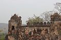
The forests of the park have a range of vegetation consisting of tropical wet evergreen forests in the lower reaches, mixed (moist and dry) deciduous forests in the middle and temperate alpine forests in the upper reaches including sal and bamboo as the major components along with a number of medicinal plants. The river Koel and its tributaries run through the northern portion of the park. There are grasslands in the river flowing area. It also has waterfalls and hot springs. Once the seat of Chero kings, there are two historical forts, one of them from the 16th century, deep inside the forest. The main sentinel of the old fort is visible high up on the hill with defences in three directions and three main gates.

Adventure Tourism

Tourist places

Schools

St Joseph-2 School, Mahuadanr St.joseph-2school,mahuadanr - panoramio.jpg
St Joseph-2 School, Mahuadanr

Schools and colleges:

See also

Related Research Articles

<span class="mw-page-title-main">Jharkhand</span> State in eastern India

Jharkhand is a state in eastern India. The state shares its border with the states of West Bengal to the east, Chhattisgarh to the west, Uttar Pradesh to the northwest, Bihar to the north and Odisha to the south. It is the 15th largest state by area, and the 14th largest by population. Hindi is the official language of the state. The city of Ranchi is its capital and Dumka its sub-capital. The state is known for its waterfalls, hills and holy places; Baidyanath Dham, Parasnath, Dewri and Rajrappa are major religious sites. Jharkhand is primarily rural, with about 24% of its population living in cities.

<span class="mw-page-title-main">Chota Nagpur Plateau</span> Plateau of India

The Chota Nagpur Plateau is a plateau in eastern India, which covers much of Jharkhand state as well as adjacent parts of Chhattisgarh, Odisha, West Bengal and Bihar. The Indo-Gangetic plain lies to the north and east of the plateau, and the basin of the Mahanadi river lies to the south. The total area of the Chota Nagpur Plateau is approximately 65,000 square kilometres (25,000 sq mi).

<span class="mw-page-title-main">Netarhat</span> Town in Jharkhand, India

Netarhat is a hill station in Latehar district in the Indian state of Jharkhand. It is also referred to as the "Queen of Chotanagpur", and is a hill station. The town is also famous for Netarhat Residential School, set up in 1954.

<span class="mw-page-title-main">Palamu district</span> District of Jharkhand in India

Palamu district is one of the twenty-four districts of Jharkhand, India. It was formed in 1892. The administrative headquarters of the district is Medininagar, situated on the Koel River.

Chandwa block is a community development block in Latehar district, in Indian state of Jharkhand. It is located around 75 km from Ranchi, the state capital. It is mineral rich like most of Jharkhand State. It lies at the junction for the NH39 and NH99 roads and is also an important railway junction.

<span class="mw-page-title-main">Latehar district</span> District of Jharkhand in India

Latehar district is one of the 24 districts of Jharkhand state in eastern India, and Latehar town is the administrative headquarters of this district. This district is part of Palamu division.

<span class="mw-page-title-main">Betla National Park</span> National park in Jharkhand, India

Betla National Park is a national park located on the Chota Nagpur Plateau in the Latehar and Palamu district of Jharkhand, India. The park hosts a wide variety of wildlife.

Barwadih is a town and Community Development Block in Latehar district of Jharkhand state in India.

The region have been inhabited since the Stone Age. Copper tools from the Chalcolithic period have been discovered. This area entered the Iron Age during the mid-2nd millennium BCE.

<span class="mw-page-title-main">Palamu fort</span> Two ruined forts in Daltonganj, India

The Palamu fort are two ruined forts located 3 k.m from Betla National Park, Latehar district on the bank of Auranga River, in the Indian state of Jharkhand. The old fort in the plains, which existed even before the Chero dynasty, was built by the King of Raksel dynasty. The original fort in the plains and the other on an adjoining hill are attributed to the kings of the Chero dynasty. The fort in the plains had defences on three sides and three main gates. The New fort was constructed by Raja Medini Ray. East India company used this fort to prison Narayan Peshwa of Tiroha and Raja Radhkrishna alis Subedar Aftab Singh mutineers of 1857.

The Burha River flows through the Latehar district of Palamu division in the Indian state of Jharkhand.

North Koel River flows through the Indian state of Jharkhand.

<span class="mw-page-title-main">Lower Ghaghri Falls</span> Waterfall in Jharkhand, India

Lower Ghaghri Falls is located 10 kilometres (6.2 mi) from Netarhat in Latehar district in the Indian state of Jharkhand. It is the 33rd highest waterfall in India. It is known for its mesmerizing beauty and a major tourist attraction in Jharkhand.

<span class="mw-page-title-main">Medininagar</span> City in Jharkhand, India

Medininagar, formerly Daltonganj, is a city municipal corporation in the Indian state of Jharkhand. It is the headquarters of Palamu division and Palamu district, as well as the subdivision and block of the same name. The city is situated on the banks of the North Koel River.

Tourism in Jharkhand refers to tourism in the Indian state of Jharkhand. Jharkhand is known for its waterfalls, hills and holy places.

Medini Rai'a.k.a.Madini Rai or Madini Rao' ruled from 1658 to 1674 in the Palamu region of Bihar, now in Jharkhand.

Latehar railway station is a small railway station in Latehar district, Jharkhand. Its code is LTHR. It serves Latehar city. The station consists of two platforms. The platforms are not well sheltered. It lacks many facilities including water and sanitation.

The Chero dynasty or Chyavana dynasty was a polity that ruled the northern regions of the Indian subcontinent, corresponding to the present-day Indian states of Bihar, Uttar Pradesh, and Jharkhand, after the fall of the Pala Empire; their rule lasted from the 12th century CE to the middle of the 15th century.

Nilamber and Pitamber, freedom fighters from Jharkhand in eastern India, were brothers who led a revolt against the East India Company in 1857. They were born in a Chemo-Senya village to a family of a Bhogta clan of the Kharwar tribe in Latehar district. Their father, Chemu Singh, was Jagirdar. They decided to declare themselves independent of company rule, inspired by the Doronda Revolt in Ranchi led by Thakur Vishwanath Shahdeo and Pandey Ganpat Rai. Chero Jagirdar Devi Baksh Rai joined them.

Raksel is a Rajput clan. They are the descendants of the Haihaiyavanshi. The Raksel Rajputs ruled several states in India during the Middle Ages and British rule, including Surguja State and Udaipur. Jaipur (kuchhwaah) Rajput Raja Man Singh was ruling Palamu prior to the rule of the Chero dynasty.

References

  1. Falling Rain Genomics, Inc - Latehar
  2. "Census of India 2011: Data from the 2001 Census, including cities, villages and towns (Provisional)". Census Commission of India. Archived from the original on 16 June 2004. Retrieved 1 November 2008.
  3. "Coal India's Magadh mine may produce 51 mtpa by 2020". Business Standard India. Press Trust of India. 6 October 2015. Retrieved 16 January 2020.
  4. "Maoist attack in Latehar". Business Standard India. Press Trust of India. 6 January 2018. Retrieved 16 January 2020.
  5. "Abhijeet Group seeks Jharkhand CM Raghuvar Das's help to revive power plant". The Economic Times. 23 March 2015. Retrieved 16 January 2020.
  6. Pillay, Ruchira Singh,Amritha (13 April 2015). "Essar Power to restart work on Rs1,000 crore Tori project in Jharkhand". Livemint. Retrieved 16 January 2020.{{cite web}}: CS1 maint: multiple names: authors list (link)