Netarhat | |
|---|---|
Town | |
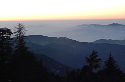
 Pine trees of Netarhat Hill station | |
 Netarhat Location in Jharkhand, India  Netarhat Netarhat (India) | |
| Coordinates: 23°28′31″N84°16′02″E / 23.47528°N 84.26722°E | |
| Country | |
| State | Jharkhand |
| District | Latehar |
| Block | Mahuadanar |
| Elevation | 1,128 m (3,701 ft) |
| Languages | |
| • Official | Hindi, Nagpuri, kurukh |
| Time zone | UTC+5:30 (IST) |
| Vehicle registration | JH-19 |
| Website | latehar |
Netarhat is a hill station in Latehar district [1] in the Indian state of Jharkhand. [2] The hill station is among the highest points of the Chhotanagpur plateau. It is known for its natural beauty of hills, forest and waterfalls. [3] It is also referred to as the "Queen of Chotanagpur". [4] [5]