Trout is a generic common name for numerous species of carnivorous freshwater ray-finned fishes belonging to the genera Oncorhynchus, Salmo and Salvelinus, all of which are members of the subfamily Salmoninae in the family Salmonidae. The word trout is also used for some similar-shaped but non-salmonid fish, such as the spotted seatrout/speckled trout.

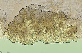
Bhutan is a sovereign country at the crossroads of East Asia and South Asia, located towards the eastern extreme of the Himalayas mountain range. It is fairly evenly sandwiched between the sovereign territory of two nations: first, the People's Republic of China (PRC) on the north and northwest. There are approximately 477 kilometres (296 mi) of border with the country's Tibet Autonomous Region (TAR), or simply Tibet. The second nation is the Republic of India on the south, southwest, and east; there are approximately 659 kilometres (409 mi) with the states of Arunachal Pradesh, Assam, West Bengal, and Sikkim, in clockwise order from the kingdom. Bhutan's total borders amount to approximately 1,139 kilometres (708 mi). The Indian state of Sikkim to the west, the India to the south, and the Assam state of India to the southeast are other close neighbours; the former two are separated by only very small stretches of Indian territory.

The brown trout is a species of salmonid ray-finned fish and the most widely distributed species of the genus Salmo, endemic to most of Europe, West Asia and parts of North Africa, and has been widely introduced globally as a game fish, even becoming one of the world's worst invasive species outside of its native range.

Haa District is one of the 20 dzongkhag or districts comprising Bhutan. An alternative name for the district is "Hidden-Land Rice Valley." It the second least-populated dzongkhag in the country after Gasa.

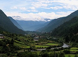
Paro District is a district (dzongkhag), valley, river and town in Bhutan. It is one of the most historic valleys in Bhutan. Both trade goods and invading Tibetans came over the pass at the head of the valley, giving Paro the closest cultural connection with Tibet of any Bhutanese district. The dominant language in Paro is Dzongkha, the national language.

Sankosh is a river that rises in northern Bhutan and empties into the Brahmaputra in the state of Assam in India. In Bhutan, it is known as the Puna Tsang Chu below the confluences of several tributaries near the town of Wangdue Phodrang.

Paro is a town and seat of Paro District, in the Paro Valley of Bhutan. It is a historic town with many sacred sites and historical buildings scattered throughout the area. It is also home to Paro International Airport, Bhutan's sole international airport. Paro International Airport is served by Drukair.

Ohrid trout or the Lake Ohrid brown trout is an endemic species of trout in Lake Ohrid and in its tributaries and outlet, the Black Drin river, in North Macedonia and Albania. Locally, the fish is known as охридска пастрмка in Macedonian and Koran or Korani in Albanian.

Salmo marmoratus, the marble trout, is a species of freshwater fish in the family Salmonidae. It is characterized by a distinctive marbled color pattern and high growth capacity. The marble trout is found in only a handful of drainages and rivers of the Adriatic basin in Italy, Slovenia, Croatia, Bosnia and Herzegovina, and Montenegro, while in Albania, the species is considered most likely extirpated.

The Raidāk River, also called Wang Chhu or Wong Chhu in Bhutan, is a trans-boundary river originating in Bhutan that is a tributary of the River Brahmaputra. It flows through Bhutan, India and Bangladesh. It is one of the main rivers in Alipurduar District, West Bengal, India.

The aquaculture of salmonids is the farming and harvesting of salmonid fish under controlled conditions for both commercial and recreational purposes. Salmonids, along with carp and tilapia, are the three most important fish groups in aquaculture. The most commonly commercially farmed salmonid is the Atlantic salmon.
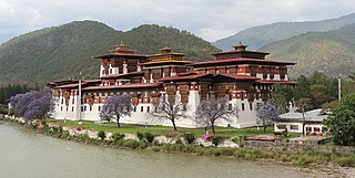
The Punakha Dzong, also known as Pungthang Dewa chhenbi Phodrang, is the administrative centre of Punakha District in Punakha, Bhutan. Constructed by Ngawang Namgyal, 1st Zhabdrung Rinpoche, in 1637–38, it is the second oldest and second-largest dzong in Bhutan and one of its most majestic structures. The dzong houses the sacred relics of the southern Drukpa Lineage of the Kagyu school of Tibetan Buddhism, including the Rangjung Kharsapani and the sacred remains of Ngawang Namgyal and the tertön Pema Lingpa.
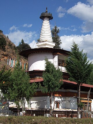
Jangtsa Dumgtseg Lhakhang[zlum brtshegs lha khang] is a Buddhist temple in western Bhutan. The temple is notable as it is in the form of a chorten, very rare in Bhutan. It is located on the edge of a hill between the Paro valley and the Dopchari valley, across the bridge from Paro. The Buddhist iconography depicted in the Chorten is considered a unique repository of the Drukpa Kagyu school.

The Kuri Chhu, also known as the Lhozhag Xung Qu or Norbu Lag Qu, is a major river of eastern Bhutan, that has formed a scenic valley with high peaks and steep hills. Kuri Chhu is a tributary of the Manas River system, which is the largest river of Bhutan and a major tributary of the Brahmaputra River that drains most of eastern Bhutan.

The Paro Chhu is a river of western Bhutan. It is a tributary of the Wong Chhu, which is known as the Raidak in its lower reaches.
The Tang Chuu is a tributary of the Mo Chhu in western Bhutan.

The Sind River or the Sindh River is a river in the Ganderbal district of the union territory of Jammu and Kashmir, India. It is a major tributary of the Jhelum River and is 108 km (67 mi) long.
The mountains of Bhutan are some of the most prominent natural geographic features of the kingdom. Located on the southern end of the Eastern Himalaya, Bhutan has one of the most rugged mountain terrains in the world, whose elevations range from 160 metres (520 ft) to more than 7,000 metres (23,000 ft) above sea level, in some cases within distances of less than 100 kilometres (62 mi) of each other. Bhutan's highest peak, at 7,570 metres (24,840 ft) above sea level, is north-central Gangkhar Puensum, close to the border with Tibet; the third highest peak, Jomolhari, overlooking the Chumbi Valley in the west, is 7,314 metres (23,996 ft) above sea level; nineteen other peaks exceed 7,000 metres (23,000 ft). Weather is extreme in the mountains: the high peaks have perpetual snow, and the lesser mountains and hewn gorges have high winds all year round, making them barren brown wind tunnels in summer, and frozen wastelands in winter. The blizzards generated in the north each winter often drift southward into the central highlands.

The Lidder or Liddar is a 73 km (45 mi) river situated in the Kashmir Valley of Jammu and Kashmir, India. It originates from the Kolahoi Glacier and feeds the Jhelum River in Mirgund Khanabal, at an altitude of 1,615 metres (5,299 ft).