Thimphu is the capital and largest city of Bhutan. It is situated in the western central part of Bhutan, and the surrounding valley is one of Bhutan's dzongkhags, the Thimphu District. The ancient capital city of Punakha was replaced by Thimphu as capital in 1955, and in 1961 Thimphu was declared as the capital of the Kingdom of Bhutan by the 3rd Druk Gyalpo Jigme Dorji Wangchuck.
Articles related to Bhutan include:

Mo Chhu is a major river in Bhutan. The word "Chhu" means "river" or "water" in Dzongkha, the official national language in Bhutan. The river rises in Gasa Dzongkhag (district) near the border between Bhutan and Tibet. From there, the Mo Chhu flows generally southward to Punakha in central Bhutan, where it joins the Pho Chhu from the northeast. The confluence of the two streams is immediately below the Punakha Dzong, which is the winter home of the Dratshang Lhentshog and the Je Khenpo. The combined streams are then joined by the Dang Chhu near the town of Wangdue Phodrang, and the name of the river becomes the Puna Tsang Chhu. The river then flows through Dagana and Tsirang Districts. After leaving Bhutan near the town of Lhamoidzingkha, formerly known as Kalikhola, the river enters Assam in India and is known as the Sankosh. The Sankosh ultimately empties into the Brahmaputra, flowing into the Bay of Bengal.

Sankosh is a river that rises in northern Bhutan and empties into the Brahmaputra in the state of Assam in India. In Bhutan, it is known as the Puna Tsang Chu below the confluences of several tributaries near the town of Wangdue Phodrang.

Paro is a town and seat of Paro District, in the Paro Valley of Bhutan. It is a historic town with many sacred sites and historical buildings scattered throughout the area. It is also home to Paro International Airport, Bhutan's sole international airport. Paro International Airport is served by Drukair.
Bhutanese architecture consists of Dzong and everyday varieties. Dzongs in Bhutan were built as fortresses and have served as religious and administrative centers since the 17th century. Secular lordly houses emerged as a distinct style in the late 19th century, during a period of relative peace in Bhutan. Throughout its history, Bhutan has mainly followed the Tibetan tradition of Buddhist architecture.

Paro Taktsang, is a sacred Vajrayana Himalayan Buddhist site located in the cliffside of the upper Paro valley in Bhutan. It is one of thirteen Tiger's Nest caves in historical Tibet in which Padmasambhava practiced and taught Vajrayana.

The Raidāk River, also called Wang Chhu or Wong Chhu in Bhutan, is a tributary of the River Brahmaputra, and a trans-boundary river. It flows through Bhutan, India and Bangladesh. It is one of the main rivers in Alipurduar District, West Bengal, India.

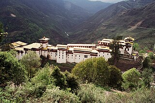
Trongsa Dzong is the largest dzong fortress in Bhutan, located in Trongsa in Trongsa district, in the centre of the country. Built on a spur overlooking the gorge of the Mangde River, a temple was first established at the location in 1543 by the Drukpa lama, Nagi Wangchuk son of Ngawang Chhojey. In 1647, his great-grandson Shabdrung Ngawang Namgyal, constructed the first dzong to replace it, called Chökhor Rabtentse Dzong with a shorter version of Choetse Dzong. It was enlarged several times during the 18th century; the Chenrezig Lhakang was built in 1715 and a whole complex, including the Maitreya (Jampa) temple, was added in 1771. The dzong has since been repaired on several occasions; it was damaged during the 1897 Assam earthquake and underwent extensive renovation in 1927 and 1999.

Simtokha Dzong also known as Sangak Zabdhon Phodrang is a small dzong. It was built in 1628 by Zhabdrung Ngawang Namgyal, who unified Bhutan. It is the first of its kind built in Bhutan. An important historical monument and former Buddhist monastery, today it houses one of the premier Dzongkha language learning institutes. It recently underwent renovation.
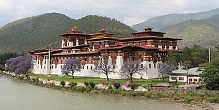
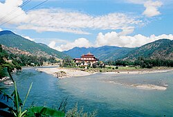
The Punakha Dzong, also known as Pungthang Dewa chhenbi Phodrang, is the administrative centre of Punakha District in Punakha, Bhutan. Constructed by Ngawang Namgyal, 1st Zhabdrung Rinpoche, in 1637–38, it is the second oldest and second-largest dzong in Bhutan and one of its most majestic structures. The dzong houses the sacred relics of the southern Drukpa Lineage of the Kagyu school of Tibetan Buddhism, including the Rangjung Kharsapani and the sacred remains of Ngawang Namgyal and the tertön Pema Lingpa.
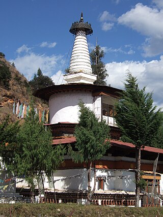
Jangtsa Dumgtseg Lhakhang[zlum brtshegs lha khang] is a Buddhist temple in western Bhutan. The temple is notable as it is in the form of a chorten, very rare in Bhutan. It is located on the edge of a hill between the Paro valley and the Dopchari valley, across the bridge from Paro. The Buddhist iconography depicted in the Chorten is considered a unique repository of the Drukpa Kagyu school.

Lhuentse Dzong is a dzong and Buddhist monastery in Lhuentse District in eastern Bhutan. It lies on the eastern side of the Kuri Chhu and is perched on a spur at the end of a narrow valley.

The Kuri Chhu, also known as the Lhozhag Xung Qu or Norbu Lag Qu, is a major river of eastern Bhutan, that has formed a scenic valley with high peaks and steep hills. Kuri Chhu is a tributary of the Manas River system, which is the largest river of Bhutan and a major tributary of the Brahmaputra River that drains most of eastern Bhutan.

The Ha Chhu is a river in west-central Bhutan, it is a tributary of the Raidak River.
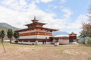
Chimi Lhakhang, also known as Chime Lhakhang or Monastery or temple, is a Buddhist monastery in Punakha District, Bhutan. Located near Lobesa, it stands on a round hillock and was founded and built in 1499 by the Drukpa Kagyu lama Ngawang Chogyal, who was the 14th abbot of Ralung Monastery.

The mountains of Bhutan are some of the most prominent natural geographic features of the kingdom. Located on the southern end of the Eastern Himalaya, Bhutan has one of the most rugged mountain terrains in the world, whose elevations range from 160 metres (520 ft) to more than 7,000 metres (23,000 ft) above sea level, in some cases within distances of less than 100 kilometres (62 mi) of each other. Bhutan's highest peak, at 7,570 metres (24,840 ft) above sea level, is north-central Gangkhar Puensum, close to the border with Tibet; the third highest peak, Jomolhari, overlooking the Chumbi Valley in the west, is 7,314 metres (23,996 ft) above sea level; nineteen other peaks exceed 7,000 metres (23,000 ft). Weather is extreme in the mountains: the high peaks have perpetual snow, and the lesser mountains and hewn gorges have high winds all year round, making them barren brown wind tunnels in summer, and frozen wastelands in winter. The blizzards generated in the north each winter often drift southward into the central highlands.