Kuri Chhu

Last updated
Kuri Chhu
Kuri Chi river flowing below the Lhuentse Dzong.jpg
Manasrivermap.png
Kuri Chhu (centre)
Location
Country Bhutan
Basin features
River system Manas River, Brahmaputra River
Suspension bridge across the Kuri Chhu river near Lhuentse Dzong Suspension bridge across the river.jpg
Suspension bridge across the Kuri Chhu river near Lhuentse Dzong

The Kuri Chhu, also known as the Lhozhag Xung Qu (tib. lho brag gzhung chu) or Norbu Lag Qu (tib. nor bu lag chu), is a major river of eastern Bhutan, that has formed a scenic valley with high peaks and steep hills. Kuri Chhu is a tributary of the Manas River system, which is the largest river of Bhutan and a major tributary of the Brahmaputra River that drains most of eastern Bhutan. [1]

Contents

Course

The Kuri Chhu originates from the Kula Kangri Glacier in the Tibet Autonomous Region of People's Republic of China where it is known as the Lhozhag Nub Qu (Tibetan: lho brag nub chu, Roman Dzongkha: Lhobrak Chhu) and Xung Qu (Tibetan: gzhung chu), and another origin is the Lhozhag Xar Qu (Tibetan: lho brag shar chu) a.k.a. Damxoi Xung Qu (tib. gtam zhol gzhung chu) originates between the Xoijin Qênri and the Tar Lhari. [2] [3] It crosses into Bhutan at a relatively low elevation of 1,200 metres (3,900 ft), [3] flowing in a southerly direction up to Nye and changes its course to south-easterly until it reaches Lhuentse Dzong. Further downstream the Kuri Chhu flows in a south-westerly direction and joins the Manas River. [4]

Tributaries

The main tributaries of the Kuri Chhu are the Khoma Chhu, Tangkhar Chhu, the Chuneygang Chhu, the Kilung Chhu, the Rong Chhu, the Nye, and Bagang Chhu and the Dungkhar Chhu. [4]

Topography

Geographically Bhutan forms a giant natural staircase. Starting from the plains of India, in the south, at an altitude of around 100 metres (330 ft), the elevation rises to the high Himalayan peaks of over 7,000 metres (23,000 ft), in the north, on the borders with Tibet. Eastern Bhutan lies across the Donga range running north–south across the country and is crossed by the 3,780-metre (12,400 ft) high Thrumshingla pass. From this high pass the terrain drops precipitously to the low valleys of the Kuri Chhu.

On a clear day, one can see Gangkhar Puensum, Bhutan's highest peak, from Thrumshingla pass. After crossing the pass, for a drive to Sengor the road descends about 700 metres (2,300 ft) in 22 kilometres (14 mi). After Sengor the road begins its descent into the Kuri Chhu valley. Numerous waterfalls and streams slide down the sharp cliffs and leap onto the road. In some places the road is critically cut into the side of the vertical cliff. Finally the road leaves Thrumshingla National Park area and emerges into the upper part of the large valley of the Kuri Chhu, lush with bamboos and ferns. The area is also good for bird watching. The winding road gradually descends through corn fields, rice terraces and tropical fruit plants begin to appear. At Zuri Zampa (bridge) it gets to the lowest point at 570 metres (1,870 ft), after a marked descent of about 3,500 metres (11,500 ft) from Thrumshingla Pass [5]

Water sports

Bhutan is emerging as a noted destination for white water sports, although tourism in the country is strictly regulated. The rivers in Bhutan generally rush down very steep slopes with great force and road access is limited. Therefore, only relatively short sections of the main rivers are suitable for kayaking and rafting. Even within these limitations Bhutan is an attractive destination for the recreational kayaker with incredible rivers that are both challenging and are amongst some of the most beautiful in the world. The Kuri Chhu offers three runsthe 14-kilometre (9 mi) upper run and the 20-kilometre (12 mi) middle run are suitable only for kayaking, but the 10-kilometre (6 mi) lower run is suitable for both rafting and kayaking. [6]

Hydropower

Bhutan location map.svg
Red pog.svg
Kuri Chhu Hydropower Plant

Bhutan's hydropower potential is estimated at 30,000 MW but harnessed capacity is only 460 MW, which includes the 60 MW run-of-the-river type project commissioned in 2001 on Kuri Chhu in Mongar District. [7] [8] Bhutan and India formed Kurichu Project Authority in 1994 to develop a power plant on the Kuri Chhu. A 55-metre (180 ft) straight gravity concrete dam was built with a surface power house operating at average net head of 32 metres (105 ft). [9]

The Kuri Chhu Hydropower Plant is located in Gyalpozhing, in the Mongar District of Eastern Bhutan. The hydropower plant was formally inaugurated by HRH Trongsa Penlop Jigme Khesar Namgyel Wangchuck and H.E Shri Sudhir Vyas, Ambassador of India to Bhutan, on April 26, 2006. The design capacity is 60 MW (4x15 MW). [10]

Weaving

Some of the villages of traditional "kushitara" weavers, linked with the royal family of Bhutan, are found in the Kuri Chhu valley near Mongar. The entire weaving process for complete kira takes between six months to one year to complete. The Bhutanese prize these textiles so highly that they are considered part of a family's wealth and are used as currency. [11] [12]

See also

Related Research Articles

<span class="mw-page-title-main">Geography of Bhutan</span>

Bhutan is a sovereign country at the crossroads of East Asia and South Asia, located towards the eastern extreme of the Himalayas mountain range. It is fairly evenly sandwiched between the sovereign territory of two nations: first, the People's Republic of China (PRC) on the north and northwest. There are approximately 477 kilometres of border with the country's Tibet Autonomous Region (TAR), or simply Tibet. The second nation is the Republic of India on the south, southwest, and east; there are approximately 659 kilometres with the states of Arunachal Pradesh, Assam, West Bengal, and Sikkim, in clockwise order from the kingdom. Bhutan's total borders amount to approximately 1,139 kilometres. The Republic of Nepal to the west, the India to the south, and the Union of Myanmar to the southeast are other close neighbours; the former two are separated by only very small stretches of Indian territory.

<span class="mw-page-title-main">Lhuntse District</span> District of Bhutan

<span class="mw-page-title-main">Mongar District</span> District of Bhutan

<span class="mw-page-title-main">Punakha</span> Administrative centre in Punakha dzongkhag, Bhutan

Punakha is the administrative centre of Punakha dzongkhag, one of the 20 districts of Bhutan. Punakha was the capital of Bhutan and the seat of government until 1955, when the capital was moved to Thimphu. It is about 72 km away from Thimphu, and it takes about 3 hours by car from the capital. Unlike Thimphu, it is quite warm in winter and hot in summer. It is located at an elevation of 1,200 metres above sea level, and rice is grown as the main crop along the river valleys of two main rivers of Bhutan, the Pho Chu and Mo Chu. Dzongkha is widely spoken in this district.

<span class="mw-page-title-main">Manas River</span> River in Bhutan, China and India

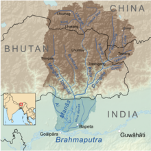
The Manas River, known in Bhutan as the Drangme Chhu, is a transboundary river in the Himalayan foothills between southern Bhutan, India, and China. It is the largest of Bhutan's four major river systems, with the other three being the Amo Chu or Torsa River, the Wang Chu or Raidak, and the Puna Tshang Chu or Sankosh. It is met by three other major streams before it again debouches into India in western Assam. The river flows for a total length of 400 kilometres (250 mi), including through Tibet for 24 km (15 mi), Bhutan for 272 kilometres (169 mi), and Assam for 104 kilometres (65 mi) before it joins the mighty Brahmaputra River at Jogighopa. A major tributary of the Manas, the Aie River, joins it in Assam at Bangpari.


Lingmethang is a small town under Salling Geog in Mongar district, in the eastern part of Bhutan. It is located off of the Thimphu-Trashigang highway, to the west of Mongar City and, 7 km north of the town of Gyalpozhing. The town lies in a lush valley just west of the Kuri Chhu river, covering approximately 80 acres at an average elevation of 650 m. The population is approximately 1,190 people.

<span class="mw-page-title-main">Raidāk River</span> Tributary of the Brahmaputra River in Bhutan, India, and Bangladesh

The Raidāk River, also called Wang Chhu or Wong Chhu in Bhutan, is a tributary of the River Brahmaputra, and a trans-boundary river. It flows through Bhutan, India and Bangladesh. It is one of the main river in Alipurduar District, India.

<span class="mw-page-title-main">Lhuntse Dzong</span> Tibetan Buddhist monastery in Lhuntse District, Bhutan

Lhuentse Dzong is a dzong and Buddhist monastery in Lhuentse District in eastern Bhutan. It lies on the eastern side of the Kuri Chhu and is perched on a spur at the end of a narrow valley.

<span class="mw-page-title-main">Paro Chhu</span> River in western Bhutan

The Paro Chhu is a river of western Bhutan. It is a tributary of the Wong Chhu, which is known as the Raidak in its lower reaches.

<span class="mw-page-title-main">Ha Chhu</span> River in Bhutan

The Ha Chhu is a river in west-central Bhutan, it is a tributary of the Raidak River.

<span class="mw-page-title-main">Rangit Dam</span> Dam in India

Rangit Dam, which forms the headworks of the Rangit Hydroelectric Power Project Stage III, is a run-of-the-river hydroelectric power project on the Ranjit River, a major tributary of the Teesta River in the South Sikkim district of the Northeastern Indian state of Sikkim. The project's construction was completed in 1999. The project is fully functional since 2000. The project was built at a cost of Rs 4922.6 million. The average annual power generation from the 60 MW project is 340 GWh with firm power of 39 MW.

<span class="mw-page-title-main">Wangchuck Centennial National Park</span> National Park of Bhutan

<span class="mw-page-title-main">Thrumshing La</span> Mountain pass in Bhutan

Thrumshing La, also called Thrumshingla Pass and Donga Pass,, is the second-highest mountain pass in Bhutan, connecting its central and eastern regions across the otherwise impregnable Donga range that has separated populations for centuries. It is located on a bend of the Lateral Road at the border of Bumthang District and Mongar District, along the border with Lhuntse District to the east. The Lateral Road bisects Thrumshingla National Park, named after the pass. The World Wildlife Fund also maintains operations in the park.

<span class="mw-page-title-main">Energy in Bhutan</span>

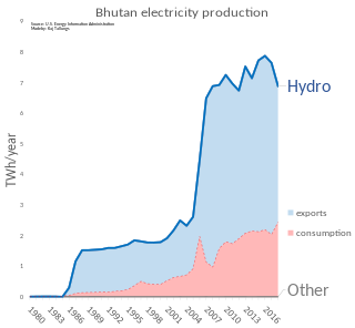
Energy in Bhutan has been a primary focus of development in the kingdom under its Five-Year Plans. In cooperation with India, Bhutan has undertaken several hydroelectric projects whose output is traded between the countries. Though Bhutan's many hydroelectric plants provide energy far in excess of its needs in the summer, dry winters and increased fuel demand makes the kingdom a marginal net importer of energy from India.

<span class="mw-page-title-main">Mountains of Bhutan</span> Highlands of Bhutan

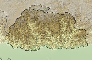
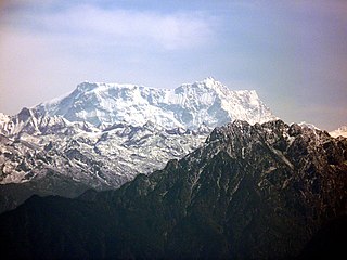
The mountains of Bhutan are some of the most prominent natural geographic features of the kingdom. Located on the southern end of the Eastern Himalaya, Bhutan has one of the most rugged mountain terrains in the world, whose elevations range from 160 metres (520 ft) to more than 7,000 metres (23,000 ft) above sea level, in some cases within distances of less than 100 kilometres (62 mi) of each other. Bhutan's highest peak, at 7,570 metres (24,840 ft) above sea level, is north-central Gangkhar Puensum, close to the border with Tibet; the third highest peak, Jomolhari, overlooking the Chumbi Valley in the west, is 7,314 metres (23,996 ft) above sea level; nineteen other peaks exceed 7,000 metres (23,000 ft). Weather is extreme in the mountains: the high peaks have perpetual snow, and the lesser mountains and hewn gorges have high winds all year round, making them barren brown wind tunnels in summer, and frozen wastelands in winter. The blizzards generated in the north each winter often drift southward into the central highlands.

Denis-Perron dam is a rockfill embankment dam spanning the Sainte-Marguerite River, a tributary of the lower Saint Lawrence River, in eastern Quebec, Canada. Standing 171 metres (561 ft) high and 378 metres (1,240 ft) long, the dam is the primary component of Hydro-Québec's Sainte-Marguerite 3 hydroelectric project. The dam is the second highest in Quebec and the hydraulic head afforded to its power plant is also the largest in the province.

Renewable energy in Bhutan is the use of renewable energy for electricity generation in Bhutan. The renewable energy sources include hydropower.

<span class="mw-page-title-main">Liankang Kangri</span>

Liangkang Kangri is a mountain peak in the Himalayas on the border between Bhutan and China, as well as at the southeastern end of territory claimed by both countries. Liangkang Kangri is 7,535 metres (24,721 ft) high. To the south, a ridge leads to the 7,570-metre (24,840 ft) Gangkhar Puensum 2 kilometres (1.2 mi) to the south-southeast. Due to the low saddle height of 234 metres (768 ft), Liangkang Kangri is not regarded as an independent mountain. Westward a ridge leads to the 6,680-metre (21,920 ft) high Chumhari Kang. The Liangkanggletscher on the northwest flank and the Namsanggletscher on the eastern flank of Liangkang Kangri form the headwaters of the Lhobrak Chhu, a source river of Kuri Chhu. The glacier on the southwest flank belongs to the catchment area of Angde Chhu.

<span class="mw-page-title-main">Tawang Chu</span> River in ; Trashiyangtse and Trashigang, India; Bhutan

Tawang Chu is the main river of the Tawang district in Arunachal Pradesh, India. The entire district may be regarded as the basin of the Tawang Chu river. In addition, two south-flowing rivers from Tibet, viz., Tsona Chu and Nyamjang Chu, join the river within the district. The combined river flows west into Bhutan, where it progresses to the Manas River and flows into the Assam state of India.

References

  1. "Eastern Bhutan" (PDF). Lonely Planet. Archived from the original (PDF) on 2011-06-07. Retrieved 2010-05-09.
  2. Zürcher, Dieter; Choden, Kunzang (2004). Bhutan, Land of Spirituality and Modernization: Role of Water in Daily Life. New Dawn Press. ISBN   1-932705-43-0.
  3. 1 2 Brown, L; Mayhew, B; Armington, S.; Whitecross, R. (2007). Bhutan. Lonely Planet. p. 84. ISBN   978-1-74059-529-2.
  4. 1 2 "Environmental Assessment - Lhuntse - Dungkhar Road" (PDF). Royal Government of Bhutan, Ministry of Communications, Division of Roads. Retrieved 2010-05-09.
  5. "Jakar (Bumthang) to Mongar". Wind Horse Tours. Retrieved 2010-05-09.
  6. "Water Sport in Bhutan". TrekkingBhutan. Retrieved 2010-05-09.
  7. Tenzin, K. "Potential Development Challenges in the Rivers of Bhutan" (PDF). Canadian Rivers Institute. Retrieved 2010-05-09.[ dead link ]
  8. "Regional Hydro-power Resources: Status of Development and Barriers" (PDF). USAID . Retrieved 2010-05-09.
  9. "Hydroelectric Power Plants in South Asia". Archived from the original on July 18, 2009. Retrieved 2010-05-09.
  10. "Kurichhu Hydropower Plant". DrukGreen.|
  11. "Eastern of Bhutan". Asia Planet. Archived from the original on 2011-07-23. Retrieved 2010-05-09.
  12. "Bhutan travel tips". Asia Planet. Retrieved 2010-05-09.

27°03′00″N91°14′15″E / 27.05000°N 91.23750°E / 27.05000; 91.23750