
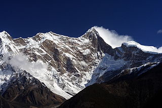
Kangchenjunga, also spelled Kanchenjunga, Kanchanjanghā and Khangchendzonga, is the third-highest mountain in the world. Its summit lies at 8,586 m (28,169 ft) in a section of the Himalayas, the Kangchenjunga Himal, which is bounded in the west by the Tamur River, in the north by the Lhonak River and Jongsang La, and in the east by the Teesta River. It lies in the border region between Koshi Province of Nepal and Sikkim state of India, with the two peaks West and Kangbachen in Nepal's Taplejung District and the other three peaks Main, Central and South directly on the border.

The Himalayas, or Himalaya is a mountain range in Asia, separating the plains of the Indian subcontinent from the Tibetan Plateau. The range has some of the Earth's highest peaks, including the highest, Mount Everest. More than 100 peaks exceeding elevations of 7,200 m (23,600 ft) above sea level lie in the Himalayas.

Cho Oyu is the sixth-highest mountain in the world at 8,188 metres (26,864 ft) above sea level. Cho Oyu means "Turquoise Goddess" in Tibetan. The mountain is the westernmost major peak of the Khumbu sub-section of the Mahalangur Himalaya 20 km west of Mount Everest. The mountain stands on the China–Nepal border, between the Tibet Autonomous Region and Koshi Province.

Shishapangma, or Shishasbangma or Xixiabangma, is the 14th-highest mountain in the world, at 8,027 metres (26,335 ft) above sea level. It is located entirely within Tibet. In 1964, it became the final eight-thousander to be climbed.

Gangkhar Puensum is the highest mountain in Bhutan and the highest unclimbed mountain in the world, with an elevation of 7,570 metres (24,836 ft) and a prominence of 2,995 metres (9,826 ft). In Dzongkha language, its name means "White Peak of the Three Spiritual Brothers".

Himalchuli is the second-highest mountain in the Mansiri Himal, part of the Nepalese Himalayas, and the 18th-highest mountain in the world. It lies south of Manaslu, one of the eight-thousanders. Himalchuli has three main peaks: East, West and North.
Namcha Barwa or Namchabarwa is a mountain peak lying in Tibet in the region of Pemako. The traditional definition of the Himalaya extending from the Indus River to the Brahmaputra would make it the eastern anchor of the entire mountain chain, and it is the highest peak of its own section as well as Earth's easternmost peak over 7,600 metres (24,900 ft). It lies in the Nyingchi Prefecture of Tibet. It is the highest peak in the 180 km long Namcha Barwa Himal range, which is considered the easternmost syntaxis/section of the Himalaya in southeastern Tibet and northeastern India where the Himalaya are said to end, although high ranges actually continue another 300 km to the east.

Zemu Gap Peak or Zemu Peak is a peak on a high ridge running east of the south summit of Kangchenjunga in the Himalayas. It is located in Sikkim, India
Tongshanjiabu, also called Gyalbu Kangri, is a mountain in the Himalayas.

Noijin Kangsang is the highest peak of Lhagoi Kangri mountain range in the Tibet Autonomous Region in China. It lies between the Yarlung Tsangpo River, Yamdrok Lake and the Himalayas mountain range.

Pauhunri is a mountain in the Eastern Himalayas. It is located on the border of Sikkim, India and Tibet and is situated about 75 km northeast of Kangchenjunga. It marks the origin of Teesta river.

Kangto at 7,090 metres (23,261 ft) is a mountain of the Eastern Himalayas located in the Indian state of Arunachal Pradesh and it shares its border with the Tibet Autonomous Region of China. It is the highest point in Arunachal Pradesh. The area in which Kangto is located lies in the Lada circle of East Kameng district of the state. On the Chinese side, it lies in Cona County of Shannan Prefecture, Tibet.

Nyegyi Kangtsang is a mountain of the Eastern Himalayas located in East Kameng district of Arunachal Pradesh state of India on the border with Tibet.

Hillary Peak is the name which has been proposed by the Government of Nepal for a 7,681 metres (25,200 ft) peak in the Himalayas in honour of Edmund Hillary, who made the first ascent of Everest with Tenzing Norgay in 1953.

Kanjiroba is a mountain in the Himalayas of Dolpa District in Nepal.
Pangpoche, also known as Panpoche I is a mountain in the Himalayas of Nepal. It has a summit elevation of 6,620 metres (21,720 ft) above sea level and is located approximately 15 kilometres (9.3 mi) northeast of the world's eighth-highest mountain, Manaslu. On the ridge of Pangpoche to the South in 1.5 kilometers is located Pangpoche II 6,504 meters.
Liangkang Kangri is a mountain peak in the Himalayas on the border between Bhutan and China, as well as at the southeastern end of territory claimed by both countries. Liangkang Kangri is 7,534 metres (24,718 ft) high. To the south, a ridge leads to the 7,570-metre (24,840 ft) Gangkhar Puensum 2.17 kilometres (1.35 mi) to the south-southeast. Due to the low saddle height of 234 metres (768 ft), Liangkang Kangri is not regarded as an independent mountain. There is westward a ridge that extends to several peaks that are around 7,000 m (23,000 ft) high. The Liangkanggletscher on the northwest flank and the Namsanggletscher on the eastern flank of Liangkang Kangri form the headwaters of the Lhobrak Chhu, a source river of Kuri Chhu. The glacier on the southwest flank belongs to the catchment area of Angde Chhu.
Chura Kang is a mountain in the main Himalayan range, located on the border between Bhutan and the autonomous region of Tibet in the People's Republic of China.


