Kumbhakarna Mountain

Last updated
Kumbhakarna
Jannu
Jannu from the Sinelapche Pass.jpg
Jannu from the south
Highest point
Elevation 7,710 m (25,300 ft) [1]
Ranked 32nd
Prominence 1,035 m (3,396 ft)
Listing List of mountains in Nepal
Coordinates 27°40′57″N88°02′15″E / 27.68250°N 88.03750°E / 27.68250; 88.03750
Geography
Nepal rel location map.svg
Red triangle with thick white border.svg
Kumbhakarna
Location in Nepal
LocationEastern Nepal
Parent range Himalayas
Climbing
First ascent April 27–28, 1962 by René Desmaison, Paul Keller, Robert Paragot, Gyalzen Mitchung Sherpa, Lionel Terray, André Bertraud, Jean Bouvier, Pierre Leroux, Yves Pollet-Villard, Jean Ravier and Wangdi Sherpa
Easiest route rock/snow/ice climb

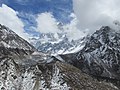
Mount Kumbhakarna or Jannu (Limbu: Phoktanglungma) is the 32nd-highest mountain in the world. It is an important western outlier of Kangchenjunga, the world's third-highest peak. Kumbhakarna is a large and steep peak in its own right, and has numerous challenging climbing routes.

Contents

The official name of this peak is Kumbhakarna, but the designation Jannu is still better known. It is called Phoktanglungma, literally "mountain with shoulders" (phoktang means "shoulder" and lungma means "mountain"), in the Limbu language, and is sacred in the Kirant religion.

Location

Kumbhakarna is the highest peak of the Kumbhakarna Section of the Kangchenjunga Himal (using H. Adams Carter's classification [2] ), which straddles the border between Nepal and Sikkim, and lies entirely within Nepal. A long ridge connects it with Kangchenjunga to the east.

Notable features

Kumbhakarna is the 32nd highest mountain in the world (using a cutoff of 500m prominence, or re-ascent). It is more notable for its climbing challenge, and is one of the hardest peaks in the world in terms of technical difficulty because of its complex structure, its vertical relief, and the particularly steep climbing near the summit. The north face, in particular, has been the scene of some of the most technical (and controversial) climbing achieved at altitudes over 7000m.

Climbing history

Kumbhakarna Jannu was first reconnoitered in 1957 by Guido Magnone, and first attempted in 1959 by a French team led by Jean Franco. It was first climbed in 1962 by a team led by the French alpinist Lionel Terray. Those reaching the summit were René Desmaison, Paul Keller, Robert Paragot and Gyalzen Mitchung Sherpa (April 27) and Lionel Terray, André Bertraud, Jean Bouvier, Pierre Leroux, Yves Pollet-Villard, Jean Ravier and Wangdi Sherpa (April 28). [3] [4] [5]

Their route started from the Yamatari Glacier south of the peak and followed a circuitous route to the large plateau known as the Throne (a hanging glacier south of the summit), continuing to the summit via the southeast ridge.

The Huge, steep north face (the so-called "Wall of Shadows") was first climbed in 1976 by a Japanese team led by Masatsugu Konishi (ja:小西政継, by a route that starts on the left side of the face and then meets the east ridge, avoiding the steep headwall at the top of the face (though a New Zealand team had climbed the north face the previous year without proceeding to the summit). A Dutch team ascended the north face in 1987, three men reached the summit but only one made it down. A Slovenian climber, Tomo Česen, claimed a solo ascent of a more direct route on the face in 1989, but this claim is considered suspect by many in the climbing community. [4]

In 2004, after a failed attempt the previous year, a Russian team led by Alexander Odintsov succeeded in climbing the direct north face route through the headwall. This required big-wall aid techniques in a sustained, committing setting at over 7500m, a major achievement. However some in the climbing community were upset to learn that the Russians left a good deal of equipment on the wall, provoking a debate over what constitutes appropriate modern style on such a route. [6] Despite the controversy, the team won the Piolet d'Or for the ascent.

On October 12th 2023, three American climbers, Alan Rousseau, Matt Cornell and Jackson Marvell reached the summit. Their climb was done with no supplemental oxygen, no ropes fixed in advance, and no porters beyond base camp, using only what they could carry on their backs. [7]

The Himalayan Index lists over a dozen ascents of Jannu; there may be others that have not been written up in climbing literature.

Related Research Articles

<span class="mw-page-title-main">Kangchenjunga</span> Third highest mountain in the world

Kangchenjunga, also spelled Kanchenjunga, Kanchanjanghā and Khangchendzonga, is the third-highest mountain in the world. Its summit lies at 8,586 m (28,169 ft) in a section of the Himalayas, the Kangchenjunga Himal, which is bounded in the west by the Tamur River, in the north by the Lhonak River and Jongsang La, and in the east by the Teesta River. It lies in the border region between Nepal and Sikkim state of India, with three of the five peaks, namely Main, Central and South, directly on the border, and the peaks West and Kangbachen in Nepal's Taplejung District.

<span class="mw-page-title-main">K2</span> 2nd-highest mountain on Earth

K2, at 8,611 metres (28,251 ft) above sea level, is the second-highest mountain on Earth, after Mount Everest at 8,849 metres (29,032 ft). It lies in the Karakoram range, partially in the Gilgit-Baltistan region of Pakistan-administered Kashmir and partially in the China-administered Trans-Karakoram Tract in the Taxkorgan Tajik Autonomous County of Xinjiang.

<span class="mw-page-title-main">Lhotse</span> Eight-thousander and 4th-highest mountain on Earth, located in Nepal and China

Lhotse is the fourth-highest mountain on Earth, after Mount Everest, K2, and Kangchenjunga. At an elevation of 8,516 metres (27,940 ft) above sea level, the main summit is on the border between Tibet Autonomous Region of China and the Khumbu region of Nepal.

<span class="mw-page-title-main">Makalu</span> Eight-thousander and 5th-highest mountain on Earth, located in Nepal and China

Makalu is the fifth-highest mountain on Earth, with a summit at an elevation of 8,485 metres (27,838 ft) AMSL. It is located in the Mahalangur Himalayas 19 km (12 mi) southeast of Mount Everest, on the China–Nepal border. One of the eight-thousanders, Makalu is an isolated peak shaped as a four-sided pyramid.

<span class="mw-page-title-main">Dhaulagiri</span> Eight-thousander and 7th-highest mountain on Earth, located in Nepal

Dhaulagiri, located in Nepal, is the seventh highest mountain in the world at 8,167 metres (26,795 ft) above sea level, and the highest mountain within the borders of a single country. It was first climbed on 13 May 1960 by a Swiss-Austrian-Nepali expedition. Annapurna I is 34 km (21 mi) east of Dhaulagiri. The Kali Gandaki River flows between the two in the Kaligandaki Gorge, said to be the world's deepest. The town of Pokhara is south of the Annapurnas, an important regional center and the gateway for climbers and trekkers visiting both ranges as well as a tourist destination in its own right.

<span class="mw-page-title-main">Manaslu</span> Eight-thousander mountain in Nepal

Manaslu is the eighth-highest mountain in the world at 8,163 metres (26,781 ft) above sea level. It is in the Mansiri Himal, part of the Nepalese Himalayas, in west-central Nepal. Manaslu means "mountain of the spirit" and the word is derived from the Sanskrit word manasa, meaning "intellect" or "soul". Manaslu was first climbed on May 9, 1956, by Toshio Imanishi and Gyalzen Norbu, members of a Japanese expedition. It is said that, given the many unsuccessful attempts by the British to climb Everest before Nepali Tenzing Norgay and New Zealander Edmund Hillary, "just as the British consider Everest their mountain, Manaslu has always been a Japanese mountain".

<span class="mw-page-title-main">Nuptse</span> Mountain in Nepal

Nuptse or Nubtse is a mountain in the Khumbu region of the Mahalangur Himal, in the Nepalese Himalayas. It lies 2 km (1.2 mi) WSW of Mount Everest. The main peak, Nuptse I at an elevation of 7,861 m (25,791 ft), was first climbed on May 16, 1961, by Dennis Davis and Sherpa Tashi. After a hiatus of almost 20 years, Nuptse again became the objective of mountaineers, with important routes being put up on its west, south, and north faces.

<span class="mw-page-title-main">Saser Kangri</span> Mountain in India

Saser Kangri is a mountain in India. It is the highest peak in the Saser Muztagh, the easternmost subrange of the Karakoram range. Sasir Kangri is located within Ladakh.

<span class="mw-page-title-main">Gaurishankar</span> Mountain in the Nepal Himalayas

Gaurishankar, a mountain in the Nepal Himalayas, is the second highest peak of the Rolwaling Himal, behind Melungtse (7,181 m). The name comes from the Hindu goddess Gauri, a manifestation of Parvati, and her consort Shankar, denoting the sacred regard it is afforded by the people of Nepal. The Sherpas name the mountain as Jomo Tseringma. The Nepal Standard Time (GMT+05:45) is based on the meridian of this mountain peak.

<span class="mw-page-title-main">Nanda Devi</span> Second-highest mountain in India

Nanda Devi is the second-highest mountain in India, after Kangchenjunga, and the highest located entirely within the country. Nanda Devi is the 23rd-highest peak in the world.

<span class="mw-page-title-main">Kamet</span> Mountain in Uttarakhand, India

Kamet is the second-highest mountain in the Garhwal region of Uttarakhand, India, after Nanda Devi. It is the 29th highest mountain in the world. It lies in the Chamoli District of Uttarakhand. Its appearance resembles a giant pyramid topped by a flat summit area with two peaks.

<span class="mw-page-title-main">Trango Towers</span> Granite spires in mountains in Pakistan

The Trango Towers are a family of rock towers situated in the Gilgit-Baltistan region, in the northern part of Pakistan. The Towers have some of the world's largest cliffs and offer some of the most challenging big wall climbing opportunities. Each year, climbers from around the world embark on expeditions to the Karakoram region to climb these granite faces. The Trango Towers are situated to the north of the Baltoro Glacier and are part of the Baltoro Muztagh, which is a sub-range within the Karakoram mountain range. The highest point within the group is the summit of Great Trango Tower at 6,286 m (20,623 ft), the east face of which features the world's greatest nearly vertical drop.

<span class="mw-page-title-main">Alan Hinkes</span> British Himalayan mountaineer

Alan Hinkes OBE is an English Himalayan high-altitude mountaineer from Northallerton in North Yorkshire. He is the first British mountaineer to claim all 14 Himalayan eight-thousanders, which he did on 30 May 2005.

<span class="mw-page-title-main">Lionel Terray</span> French climber and mountaineer

Lionel Terray was a French climber who made many first ascents, including on the 1955 French Makalu expedition in the Himalaya and Cerro Fitz Roy in the Patagonian Andes.

<span class="mw-page-title-main">Mera Peak</span> Mountain peak in Nepal

Mera Peak is a mountain in the Mahalangur section, Barun sub-section of the Himalaya and administratively in Nepal's Sagarmatha Zone, Sankhuwasabha. At 6,476 metres (21,247 ft) it is classified as a trekking peak. It contains three main summits: Mera North, 6,476 metres (21,247 ft); Mera Central, 6,461 metres (21,198 ft); and Mera South, 6,065 metres (19,898 ft), as well as a smaller "trekking summit", visible as a distinct summit from the south but not marked on most maps of the region.

<span class="mw-page-title-main">Nilkantha (mountain)</span> Mountain in Uttarakhand, India

Nilkantha is a major peak of the Garhwal division of the Himalayas, in the Uttarakhand region of the Indian state of Uttarakhand. Although substantially lower than the highest peaks of the region, it towers dramatically over the valley of the Alaknanda River and rises 3,474 metres (11,398 ft) above the Hindu pilgrimage site of Badrinath, only 9 km (6 mi) to the east. Frank Smythe described the peak as "second only to Siniolchu in Himalayan beauty."

<span class="mw-page-title-main">Thalay Sagar</span>

Thalay Sagar is a mountain in the Gangotri Group of peaks in the western Garhwal Himalayas, on the main ridge that lies south of the Gangotri Glacier. It lies in the northern Indian state of Uttarakhand, 10 kilometres (6 mi) southwest of the Hindu holy site of Gaumukh. It is the second highest peak on the south side of the Gangotri Glacier, but it is more notable for being a dramatic rock peak, steep on all sides, and a famed prize for mountaineers. It is adjacent to the Jogin group of peaks, and has the lake Kedartal at its base.

Jongsong Peak is a mountain in the Janak section of the Himalayas. At 7,462 metres (24,482 ft) it is the 57th highest peak in the world, although it is dominated by the 3rd highest, Kangchenjunga, 20 km (12 mi) to the south. Jongsong's summit is on tripoint of India, Nepal and China.

<span class="mw-page-title-main">1955 British Kangchenjunga expedition</span> First ascent of the 3rd highest mountain

The 1955 British Kangchenjunga expedition succeeded in climbing the 28,168-foot (8,586 m) Kangchenjunga, the third highest mountain in the world, for the first time. The expedition complied with a request from the Sikkim authorities that the summit should not be trodden on so the climbers deliberately stopped about five feet below the summit. George Band and Joe Brown reached the top on 25 May 1955, and they were followed the next day by Norman Hardie and Tony Streather. The expedition was led by Charles Evans who had been deputy leader on the 1953 British Mount Everest expedition.

<span class="mw-page-title-main">1955 French Makalu expedition</span> First ascent of fifth-highest mountain in the world

The 1955 French Makalu expedition was the first to successfully climb Makalu, the Himalayan mountain 12 miles (19 km) to the southeast of Mount Everest, on the border between Nepal and Tibet. At 8,485 metres (27,838 ft) Makalu is the fifth-highest mountain in the world and an eight-thousander.

References

  1. Kangchenjunga (Map). 1:120,000. Cartography by Himalayan Maphouse Pvt Ltd. Nepa Maps. § C6.
  2. H. Adams Carter, "Classification of the Himalaya", American Alpine Journal 59 (1985), pp. 109–141
  3. Liz Hawley, Himalayan Database
  4. 1 2 Andy Fanshawe and Stephen Venables, Himalaya Alpine Style, Hodder and Stoughton, 1995.
  5. High Asia: An Illustrated History of the 7000 Metre Peaks by Jill Neate, ISBN   0-89886-238-8
  6. American Alpine Journal 79 (2005), pp. 56–63.
  7. "Three American Climbers Solve 'The Last Great Problem in the Himalayas'". NY Times.