Annapurna II

Last updated
Annapurna II
Annapurna II north.jpg
The Northeastern Face of Annapurna II
Highest point
Elevation 7,937 m (26,040 ft)
Ranked 16th
Prominence 2,437 m (7,995 ft)
Parent peak Annapurna I
Isolation 29.02 km (18.03 mi)
Listing
Coordinates 28°32′9″N84°7′17″E / 28.53583°N 84.12139°E / 28.53583; 84.12139
Geography
Annapurna II
Transparent.svg
Transparent.svg
60km
37miles
Nuvola Buthanese flag.svg
Bhutan
Nuvola Nepal flag.svg
Nepal
Nuvola Tajik flag.svg
Nuvola Islamic Emirate of Afghanistan flag.svg
Nuvola Pakistani flag.svg
Pakistan
Nuvola Indian flag.svg
India
Nuvola Chinese flag.svg
China
Maki-mountain-15.svg
45
Transparent square.svg
Maki-mountain-15.svg
44
Transparent square.svg
Maki-mountain-15.svg
43
Transparent square.svg
Maki-mountain-15.svg
42
Transparent square.svg
Maki-mountain-15.svg
41
Transparent square.svg
Maki-mountain-15.svg
40
Transparent square.svg
Maki-mountain-15.svg
39
Transparent square.svg
Maki-mountain-15.svg
38
Transparent square.svg
Maki-mountain-15.svg
37
Transparent square.svg
Maki-mountain-15.svg
36
Transparent square.svg
Maki-mountain-15.svg
35
Transparent square.svg
Maki-mountain-15.svg
34
Transparent square.svg
Maki-mountain-15.svg
33
Transparent square.svg
Maki-mountain-15.svg
32
Transparent square.svg
Maki-mountain-15.svg
31
Transparent square.svg
Maki-mountain-15.svg
30
Transparent square.svg
Maki-mountain-15.svg
29
Transparent square.svg
Maki-mountain-15.svg
28
Transparent square.svg
Maki-mountain-15.svg
27
Transparent square.svg
Maki-mountain-15.svg
26
Transparent square.svg
Maki-mountain-15.svg
25
Transparent square.svg
Maki-mountain-15.svg
24
Transparent square.svg
Maki-mountain-15.svg
23
Transparent square.svg
Maki-mountain-15.svg
22
Transparent square.svg
Maki-mountain-15.svg
21
Transparent square.svg
Maki-mountain-15.svg
20
Transparent square.svg
Maki-mountain-15.svg
19
Transparent square.svg
Maki-mountain-15.svg
18
Transparent square.svg
Red-mountain-15.svg
17
Transparent square.svg
Maki-mountain-15.svg
16
Transparent square.svg
Maki-mountain-15.svg
15
Transparent square.svg
Maki-mountain-15.svg
14
Transparent square.svg
Maki-mountain-15.svg
13
Transparent square.svg
Maki-mountain-15.svg
12
Transparent square.svg
Maki-mountain-15.svg
11
Transparent square.svg
Maki-mountain-15.svg
10
Transparent square.svg
Maki-mountain-15.svg
9
Transparent square.svg
Maki-mountain-15.svg
8
Transparent square.svg
Maki-mountain-15.svg
7
Transparent square.svg
Maki-mountain-15.svg
6
Transparent square.svg
Maki-mountain-15.svg
5
Transparent square.svg
Maki-mountain-15.svg
4
Transparent square.svg
Maki-mountain-15.svg
3
Transparent square.svg
Maki-mountain-15.svg
2
Transparent square.svg
Maki-mountain-15.svg
1
Transparent square.svg
The major peaks (not mountains) above 7,500 m (24,600 ft) height in Himalayas, rank identified in Himalayas alone (not the world). [1]
Location Annapurna Massif, Gandaki Province, Nepal
Parent range Annapurna
Climbing
First ascent May 17, 1960
Easiest route snow/ice climb
Normal route West Ridge

Annapurna II is the second-highest mountain of the Annapurna range located in Nepal, and the eastern anchor of the range.

Contents

In terms of elevation, isolation (distance to a higher summit, namely Annapurna I East Peak, 29.02 km or 18.03 mi) and prominence (2,437 m or 7,995 ft), Annapurna II does not rank far behind Annapurna I Main, which serves as the western anchor. It is a fully independent peak, despite the close association with Annapurna I Main which its name implies; it is, however, closely connected to the shorter Annapurna IV. Annapurna II is the 16th highest mountain in the world, and the highest ultra-prominent peak on Earth under eight-thousand metres.

Features

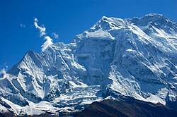
Annapurna II sits apart from the main ridge of the Annapurna Massif, along with the shorter Annapurna IV. Its summit proper lies along a steep rock ridge, relatively free of snow towards its highest point, which drops in altitude to run west to the summit of the smaller peak. The South Face is a large pyramidal wall only interrupted by the central spur, while the North Face is more complex, with steep walls cascading between ice fields near the summit and base of the mountain. To the northwest, a large hanging glacier occupies the flank between it and Annapurna IV, while the Northeastern wall has a distinctive, recurrent series of cornices and rock bands resembling a human face or skull, visible in the above photograph.

Annapurna II is notable for its large avalanches, especially those originating from the high snowpack behind the North-central buttress. Other dangers include rockfall, large ice overhangs, and frequent storms. These have limited the scope of mountaineering expeditions, indeed, the standard route of ascent uses the central connecting ridge with Annapurna IV to bypass many of its objective hazards.

Climbing history

It was first climbed in 1960 by a British/Indian/Nepalese team led by J. O. M. Roberts via the West Ridge, reached by climbing the North face of Annapurna IV. The summit party comprised Richard Grant, Chris Bonington, and Sherpa Ang Nyima. [2]

Yugoslavs from Slovenia repeated this ascent in 1969, also climbing Annapurna IV. Kazimir Drašlar and Matija Maležič reached the summit. [3] In 1973 Japanese took a shortcut by climbing directly up the north face between IV and V before continuing along the west ridge. Katsuyuki Kondo reached the top by himself. [4]

In 1983, Tim Macartney-Snape planned and participated in an expedition to Annapurna II (7,937 m or 26,040 ft), reaching the summit via the first ascent of the south spur. The descent was delayed by a blizzard and the expedition ran out of food during the last five days. They were reported missing and when the expedition eventually returned they received significant publicity. [5]

On Feb 4, 2007; Philipp Kunz, Lhakpa Wangel, Temba Nuru and Lhakpa Thinduk made the first winter ascent. The team followed the route of the first ascent from the north. [4]

References

  1. "Peak Bagger:Himalaya, Central Nepal Himalaya, Khumbu, Ghurka Himal, Annapurna Himal, Xishapangma Area, Sikkim-Eastern Nepal Himalaya, Western Nepal Himalaya, Assam Himalaya, Punjab Himalaya, Bhutan Himalaya, Garwhal Himalaya, Ganesh Himal" . Retrieved 22 October 2024.
  2. Roberts, J.O.M. (1960). "ANNAPURNA II, 1960". The Himalayan Journal. 22 (4). The Himalayan Club. Retrieved 13 May 2019.
  3. "Asia, Nepal, Annapuran II and IV". American Alpine Journal . 17 (1). American Alpine Club: 180. Retrieved 2025-05-26.
  4. 1 2 "Asia, Nepal, Upper Dolpo, Annapurna Himal, Annapurna II, First Winter Ascent". American Alpine Journal. 50 (82). American Alpine Club: 388. Retrieved 2025-05-26.
  5. Hall, Lincoln (1985). White limbo: The first Australian Climb of Mt. Everest. Random House Australia. ISBN   978-1-74166-864-3.

See also