
Annapurna is a mountain situated in the Annapurna mountain range of Gandaki Province, north-central Nepal. It is the tenth highest mountain in the world at 8,091 metres (26,545 ft) above sea level and is well known for the difficulty and danger involved in its ascent.

Dhaulagiri is the seventh highest mountain in the world at 8,167 metres (26,795 ft) above sea level, and the highest mountain within the borders of a single country (Nepal). It was first climbed on 13 May 1960 by a Swiss-Austrian-Nepali expedition. Annapurna I is 34 km (21 mi) east of Dhaulagiri. The Kali Gandaki River flows between the two in the Kaligandaki Gorge, said to be the world's deepest. The town of Pokhara is south of the Annapurnas, an important regional center and the gateway for climbers and trekkers visiting both ranges as well as a tourist destination in its own right.

Manaslu is the eighth-highest mountain in the world at 8,163 metres (26,781 ft) above sea level. It is in the Mansiri Himal, part of the Nepalese Himalayas, in the west-central part of Nepal. The name Manaslu means "mountain of the spirit" and is derived from the Sanskrit word manasa, meaning "intellect" or "soul". Manaslu was first climbed on May 9, 1956, by Toshio Imanishi and Gyalzen Norbu, members of a Japanese expedition. It is said that, given the many unsuccessful attempts by the British to climb Everest before New Zealander Edmund Hillary, "just as the British consider Everest their mountain, Manaslu has always been a Japanese mountain".

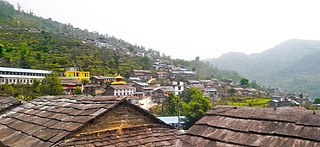
Pokhara is a metropolitan city in Nepal, which serves as the capital of Gandaki Province. It is the second most populous city of Nepal after Kathmandu, with 518,452 inhabitants living in 101,669 households in 2021. It is the country's largest metropolitan city in terms of area. The city also serves as the headquarters of Kaski District. Pokhara is located 200 kilometres west of the capital, Kathmandu. The city is on the shore of Phewa Lake, and sits at an elevation of approximately 822m. The Annapurna Range, with three out of the ten highest peaks in the world—Dhaulagiri, Annapurna I and Manaslu—is within 15–35 mi (24–56 km) of the valley.

The Kali Gandaki Gorge or Andha Galchi is the gorge of the Kali Gandaki in the Himalayas in Nepal. By some sources, it may be one of the deepest gorges in the world.

Annapurna II is part of the Annapurna mountain range located in Nepal, and is the eastern anchor of the range.

The Gandaki River, also known as the Narayani and the Gandak, is one of the major rivers in Nepal and a left bank tributary of the Ganges in India. Its total catchment area amounts to 46,300 km2 (17,900 sq mi), most of it in Nepal. In the Nepal Himalayas, it is notable for its deep canyon. The basin also contains three mountains over 8,000 m (26,000 ft), namely Dhaulagiri, Manaslu and Annapurna I. Dhaulagiri is the highest point of the Gandaki basin.

Annapurna IV is a mountain of the Annapurna mountain range in the Himalayas which is located in Nepal. Along with the taller Annapurna II, it is isolated from the other peaks in the range via a major col. It is the 4th highest peak of the range. It was first climbed in 1955 by a German expedition led by Heinz Steinmetz via the North Face and Northwest Ridge. The summit party comprised Steinmetz, Harald Biller, and Jürgen Wellenkamp.

Annapurna South is a mountain in the Annapurna Himal range of the Himalayas located in Nepal, and the 101st-highest mountain in the world. It is the 5th highest peak of the Annapurna mountain range. It was first ascended in 1964, and is 7,219 metres (23,684 ft) tall. The nearby mountain Hiunchuli is in fact an extension of Annapurna South.

Kaski District, a part of Gandaki Province, is one of the seventy-seven districts of Nepal. The name is disambiguated from Kaskikot, the ancient Kaski Kingdom.
Annapurna is a massif in the Himalayas, in north-central Nepal.

Manang is a town in the Manang District of Nepal. It is located at 28°40'0N 84°1'0E with an altitude of 3,519 metres (11,545 ft). According to the preliminary result of the 2011 Nepal census it has a population of 6,527 people living in 1,495 individual households. Its population density is 3 persons/km2.
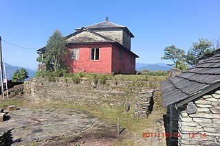
Kaskikot, commonly known as Kaski, is a Ward no. 24 of the Pokhara metropolitan city. It was earlier a part of the village development committee in Kaski District, a region in northern-central Nepal.

Yuyutsu Sharma is a Nepalese-Indian poet and journalist. He was born at Nakodar, Punjab and moved to Nepal at an early age. He writes in English and Nepali.

Annapurna Conservation Area is Nepal's largest protected area covering 7,629 km2 (2,946 sq mi) in the Annapurna range of the Himalayas. It ranges in elevation from 790 m (2,590 ft) to the peak of Annapurna I at 8,091 m (26,545 ft). The conservation area stretches across Manang, Mustang, Kaski, Myagdi, and Lamjung Districts. Annapurna Conservation Area encompasses Annapurna Sanctuary and is known for several trekking routes including Annapurna Circuit.

The Annapurna Circuit is a trek within the mountain ranges of central Nepal. The total length of the route varies between 160–230 km (100-145 mi), depending on where motor transportation is used and where the trek is ended. This trek crosses two different river valleys and encircles the Annapurna Massif. The path reaches its highest point at Thorung La pass (5416m/17769 ft), reaching the edge of the Tibetan plateau. Most trekkers hike the route anticlockwise, as this way the daily altitude gain is slower, and crossing the high Thorong La pass is easier and safer.
Annapurna Rural Municipality, Kaski is a Gaunpalika in Kaski District in Gandaki Province of Nepal named after the Annapurna Mountain. On 12 March 2017, the Government of Nepal implemented a new local administrative structure. With the implementation of the new local administrative structure, VDSs have been replaced with Municipal and Village Councils. Annapurna Gaupalika is one of these 753 local units.

Gangapurna is a mountain in Gandaki Province, Nepal. It is part of the Annapurna mountain range in north-central Nepal at an elevation of 7,455 metres (24,459 ft) and with the prominence of 563 metres (1,847 ft). It was first ascended in 1965 by a German expedition via its south face and east ridge. Gangapurna is entirely located in the Annapurna Conservation Area.
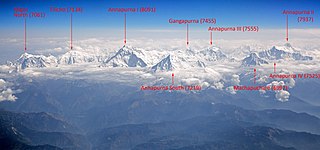
Annapurna is a massif in the Himalayas in north-central Nepal that includes one peak over 8,000 metres (26,247 ft), thirteen peaks over 7,000 metres (22,966 ft), and sixteen more over 6,000 metres (19,685 ft). The massif is 55 kilometres (34 mi) long, and is bounded by the Kali Gandaki Gorge on the west, the Marshyangdi River on the north and east, and by Pokhara Valley on the south. At the western end, the massif encloses a high basin called the Annapurna Sanctuary. The highest peak of the massif, Annapurna I Main, is the tenth highest mountain in the world at 8,091 metres (26,545 ft) above sea level. Maurice Herzog led a French expedition to its summit through the north face in 1950, making it the first eight-thousand meter peak ever successfully climbed.

