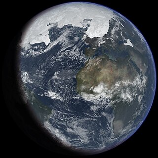
An ice age is a long period of reduction in the temperature of Earth's surface and atmosphere, resulting in the presence or expansion of continental and polar ice sheets and alpine glaciers. Earth's climate alternates between ice ages and greenhouse periods, during which there are no glaciers on the planet. Earth is currently in the ice age called Quaternary glaciation. Individual pulses of cold climate within an ice age are termed glacial periods, and intermittent warm periods within an ice age are called interglacials or interstadials.

The Himalayas, or Himalaya, is a mountain range in Asia, separating the plains of the Indian subcontinent from the Tibetan Plateau. The range has some of the Earth's highest peaks, including the highest, Mount Everest; over 100 peaks exceeding elevations of 7,200 m (23,600 ft) above sea level lie in the Himalayas.

A moraine is any accumulation of unconsolidated debris, sometimes referred to as glacial till, that occurs in both currently and formerly glaciated regions, and that has been previously carried along by a glacier or ice sheet. It may consist of partly rounded particles ranging in size from boulders down to gravel and sand, in a groundmass of finely-divided clayey material sometimes called glacial flour. Lateral moraines are those formed at the side of the ice flow, and terminal moraines were formed at the foot, marking the maximum advance of the glacier. Other types of moraine include ground moraines and medial moraines.

The Karakoram is a mountain range in the Kashmir region spanning the borders of Pakistan, China, and India, with the northwestern extremity of the range extending to Afghanistan and Tajikistan. Most of the Karakoram mountain range falls under the jurisdiction of Gilgit-Baltistan, which is administered by Pakistan. Its highest peak, K2, is located in Gilgit-Baltistan. It begins in the Wakhan Corridor (Afghanistan) in the west, encompasses the majority of Gilgit-Baltistan, and extends into Ladakh and Aksai Chin.

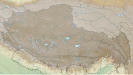
The geography of Tibet consists of the high mountains, lakes and rivers lying between Central, East and South Asia. Traditionally, Western sources have regarded Tibet as being in Central Asia, though today's maps show a trend toward considering all of modern China, including Tibet, to be part of East Asia. Tibet is often called "the roof of the world," comprising tablelands averaging over 4,950 metres above the sea with peaks at 6,000 to 7,500 m, including Mount Everest, on the border with Nepal.

The Last Glacial Period (LGP), also known colloquially as the Last Ice Age or simply Ice Age, occurred from the end of the Eemian to the end of the Younger Dryas, encompassing the period c. 115,000 – c. 11,700 years ago. The LGP is part of a larger sequence of glacial and interglacial periods known as the Quaternary glaciation which started around 2,588,000 years ago and is ongoing. The definition of the Quaternary as beginning 2.58 million years ago (Mya) is based on the formation of the Arctic ice cap. The Antarctic ice sheet began to form earlier, at about 34 Mya, in the mid-Cenozoic. The term Late Cenozoic Ice Age is used to include this early phase. The previous ice age, the Saale glaciation, which ended about 128,000 years ago, was more severe than the Last Glacial Period in some areas such as Britain, but less severe in others.

Pokhara is a metropolitan city in central Nepal, which serves as the capital of Gandaki Province. It is the second most populous city of Nepal after Kathmandu, with 599,504 inhabitants living in 120,594 households in 2021. It is the country's largest metropolitan city in terms of area. The city also serves as the headquarters of Kaski District. Pokhara is located 200 kilometres west of the capital, Kathmandu. The city is on the shore of Phewa Lake, and sits at an elevation of approximately 822m. The Annapurna Range, with three out of the ten highest peaks in the world—Dhaulagiri, Annapurna I and Manaslu—is within 15–35 mi (24–56 km) of the valley. The current mayor of Pokhara is Dhana Raj Acharya from CPN.

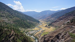
Langtangvalley is a Himalayan valley in the mountains of north-central Nepal, known for its trekking routes and natural environment.
Jumla District, is one of the ten districts of the Karnali province of Nepal. This district has Jumla as its headquarters, an area of 2,531 square kilometres (977 sq mi); it had populations of 89,427 and 108,921, respectively, in the national censuses of 2001 and 2011. Its territory lies between longitudes 81⁰ 28' and 82⁰ 18' East, and between latitudes 28⁰ 58' and 29⁰ 30' North.

A glacial lake outburst flood (GLOF) is a type of outburst flood caused by the failure of a dam containing a glacial lake. An event similar to a GLOF, where a body of water contained by a glacier melts or overflows the glacier, is called a jökulhlaup. The dam can consist of glacier ice or a terminal moraine. Failure can happen due to erosion, a buildup of water pressure, an avalanche of rock or heavy snow, an earthquake or cryoseism, volcanic eruptions under the ice, or massive displacement of water in a glacial lake when a large portion of an adjacent glacier collapses into it.

Glacier morphology, or the form a glacier takes, is influenced by temperature, precipitation, topography, and other factors. The goal of glacial morphology is to gain a better understanding of glaciated landscapes and the way they are shaped. Types of glaciers can range from massive ice sheets, such as the Greenland ice sheet, to small cirque glaciers found perched on mountain tops. Glaciers can be grouped into two main categories:

Phewa Lake, Phewa Tal or Fewa Lake is a freshwater lake in Nepal formerly called Baidam Tal located in the south of the Pokhara Valley that includes Pokhara city and parts of Sarangkot and Kaskikot. It is the second largest lake in Nepal and the largest in Gandaki Province after the Rara lake in comparison to Nepal's water bodies. It is the most popular and most visited lake in Nepal. Phewa lake is located at an altitude of 742 m (2,434 ft) and covers an area of about 5.7 km2 (2.2 sq mi). It has an average depth of about 8.6 m (28 ft) and a maximum depth of 24 m (79 ft). The maximum water capacity of the lake is approximately 43,000,000 cubic metres (35,000 acre⋅ft). The Annapurna range on the north is only about 28 km away from the lake. The lake is also famous for the reflection of mount Machhapuchhre and other mountain peaks of the Annapurna and Dhaulagiri ranges on its surface. The Tal Barahi Temple is situated on an island in the lake. It is located 4 km from the city's centre Chipledhunga.

Lobate debris aprons (LDAs) are geological features on Mars, first seen by the Viking Orbiters, consisting of piles of rock debris below cliffs. These features have a convex topography and a gentle slope from cliffs or escarpments, which suggest flow away from the steep source cliff. In addition, lobate debris aprons can show surface lineations as do rock glaciers on the Earth.
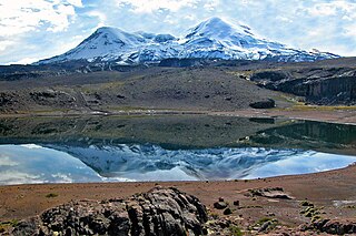
Coropuna is a dormant compound volcano located in the Andes mountains of southeast-central Peru. The upper reaches of Coropuna consist of several perennially snowbound conical summits, lending it the name Nevado Coropuna in Spanish. The complex extends over an area of 240 square kilometres (93 sq mi) and its highest summit reaches an altitude of 6,377 metres (20,922 ft) above sea level. This makes the Coropuna complex the third-highest of Peru. Its thick ice cap is the most extensive in Earth's tropical zone, with several outlet glaciers stretching out to lower altitudes. Below an elevation of 5,000 metres (16,000 ft), there are various vegetation belts which include trees, peat bogs, grasses and also agricultural areas and pastures.

The last glacial period and its associated glaciation is known in southern Chile as the Llanquihue glaciation. Its type area lies west of Llanquihue Lake where various drifts or end moraine systems belonging to the last glacial period have been identified. The glaciation is the last episode of existence of the Patagonian Ice Sheet. Around Nahuel Huapi Lake the equivalent glaciation is known as the Nahuel Huapi Drift.

The flora of Nepal is one of the richest in the world due to the diverse climate, topology and geography of the country. Research undertaken in the late 1970s and early 1980s documented 5067 species of which 5041 were angiosperms and the remaining 26 species were gymnosperms. The Terai area has hardwood, bamboo, palm, and sal trees. Notable plants include the garden angelica, Luculia gratissima, Meconopsis villosa, and Persicaria affinis. However, according to ICOMOS checklist, in the protected sites, there are 2,532 species of vascular plants under 1,034 genera and 199 families. The variation in figures is attributed to inadequate floral coverage filed studies. Some of the plants contain medicinal values. It contains certain chemical which is used to heal wound by There are 400 species of vascular plants which are endemic to Nepal. Of these, two in particular are orchids Pleione coronaria and Oreorchis porphyranthes. The most popular endemic plant of Nepal is rhododendron (arboreum) which in Nepali language is called lali guras.

The Quelccaya Ice Cap is the second largest glaciated area in the tropics, after Coropuna. Located in the Cordillera Oriental section of the Andes mountains in Peru, the cap covers an area of 42.8 square kilometres (16.5 sq mi) with ice up to 200 metres (660 ft) thick. It is surrounded by tall ice cliffs and a number of outlet glaciers, the largest of which is known as Qori Kalis Glacier; lakes, moraines, peat bogs and wetlands are also present. There is a rich flora and fauna, including birds that nest on the ice cap. Quelccaya is an important source of water, eventually melting and flowing into the Inambari and Vilcanota Rivers.
Sita cave is located at Sulikot Gaupalika, Swara in Gorkha district of Nepal at the elevation of 1165 m above the sea level. It spreads from Surpani, Auawang, Aruchanaute to Arughat. The cave is about 2 feet wide and 40 feet high. The total length is unknown due to inaccessibility, but is believed to be longest in Nepal.

Lake Washburn is a lake that formerly existed in the Taylor Valley, McMurdo Dry Valleys, Antarctica. It formed when climatic changes and an expansion of ice caused the flooding of the valley, between 23,000 and 8,340 radiocarbon years ago. Its extent and elevation are unclear but Lake Bonney and Lake Fryxell are considered to be its present-day remnant.
The Tsergo Ri landslide was a prehistoric landslide in the Nepalese Himalaya, which took place around 51,000±13,000 years ago, during the Last Glacial Period. During the collapse, a mass of rock of about 10–15 cubic kilometres (2.4–3.6 cu mi) detached from a previous mountain or ridge and descended with a speed of about 450 kilometres per hour (120 m/s); later, glaciers eroded almost the entire landslide mass. Previously weakened rocks may have contributed to the collapse, which was probably started by an earthquake.