Extreme points of Bhutan

Last updated
Bhutan location map.svg
Red pog.svg
North (disputed)
Red pog.svg
North (undisputed)
Red pog.svg
South
Red pog.svg
West
Red pog.svg
East
Red pog.svg
Highest
Extreme points of Bhutan
Map of Bhutan Bhutan CIA WFB 2010 map.png
Map of Bhutan

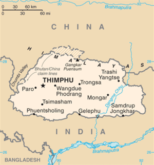
This is a list of the extreme points of Bhutan .

Country extreme points

Latitude and longitude

Altitude

Highest attainable by transportation

Highest geographical features

See also


Related Research Articles

Geography of Bhutan

The Kingdom of Bhutan is a sovereign nation, located towards the eastern extreme of the Himalayas mountain range. It is fairly evenly sandwiched between the sovereign territory of two nations: first, the People's Republic of China on the north and northwest. There are approximately 477 kilometres of border with that nation's Tibet Autonomous Region. The second nation is the Republic of India on the south, southwest, and east; there are approximately 659 kilometres with the states of Arunachal Pradesh, Assam, West Bengal, and Sikkim, in clockwise order from the kingdom. Bhutan's total borders amount to 1,139 kilometres. The Republic of Nepal to the west, the People's Republic of Bangladesh to the south, and the Union of Myanmar to the southeast are other close neighbours; the former two are separated by only very small stretches of Indian territory.

Wangdue Phodrang District District of Bhutan

Wangdue Phodrang District is a dzongkhag (district) of central Bhutan. This is also the name of the dzong which dominates the district, and the name of the small market town outside the gates of the dzong—it is the capital of Wangdue Phodrang District). The name is said to have been given by the Shabdrung Ngawang Namgyal who was searching for the best location for a dzong to prevent incursions from the south. The word "wangdue" means unification of Country, and "Phodrang" means Palace in Dzongkha.

Dagana District District of Bhutan

Dagana District is a district located in Bhutan. Most of the district is populated by Dzongkha speakers. However, in the southwest part near the Sarpang District, Nepali is also spoken as a native language.

Gasa District District of Bhutan

Gasa District or Gasa Dzongkhag is one of the 20 dzongkhags (districts) comprising Bhutan. The capital of Gasa District is Gasa Dzong near Gasa. It is located in the far north of the county and spans the Middle and High regions of the Tibetan Himalayas. The dominant language of the district is Dzongkha, which is the national language. Related languages, Layakha and Lunanakha, are spoken by semi-nomadic communities in the north of the district. The People's Republic of China claims the northern part of Gasa District.

Punakha District District of Bhutan

Punakha District is one of the 20 dzongkhags (districts) comprising Bhutan. It is bordered by Thimphu, Gasa, and Wangdue Phodrang Districts. The dominant language in the district is Dzongkha, the national language.

Trongsa Place in Trongsa District, Bhutan

Trongsa, previously Tongsa, is a Thromde or town, and the capital of Trongsa District in central Bhutan. The name means "new village" in Dzongkha. The first temple was built in 1543 by the Drukpa lama Ngagi Wangchuck, who was the great-grandfather of Ngawang Namgyal, Zhabdrung Rinpoche, the unifier of Bhutan.

Highest unclimbed mountain Summit never reached by mountaineers

An unclimbed mountain is a mountain peak that has yet to be climbed to the top. Determining which unclimbed peak is highest is often a matter of controversy. In some parts of the world, surveying and mapping are still unreliable. There are no comprehensive records of the routes of explorers, mountaineers, and local inhabitants. In some cases, even modern ascents by larger parties have been poorly documented and, with no universally recognized listing, the best that can be achieved in determining the world's highest unclimbed peaks is somewhat speculative. Most sources indicate that Gangkhar Puensum in Bhutan or on the Bhutan–China border is the tallest mountain in the world that has yet to be fully summited. Gangkhar Puensum has been off limits to climbers since 1994 when Bhutan prohibited all mountaineering above 6,000 m (20,000 ft) due to spiritual/religious beliefs.

Articles related to Bhutan include:

Mo Chhu

Mo Chhu is a major river in Bhutan. The word "Chhu" means "river" or "water" in Dzongkha, the official national language in Bhutan. The river rises in Gasa Dzongkhag (district) near the border between Bhutan and Tibet. From there, the Mo Chhu flows generally southward to Punakha in central Bhutan, where it joins the Pho Chhu from the northeast. The confluence of the two streams is immediately below the Punakha Dzong, which is the winter home of the Dratshang Lhentshog and the Je Khenpo. The combined streams are then joined by the Dang Chhu near the town of Wangdue Phodrang, and the name of the river becomes the Puna Tsang Chhu. The river then flows through Dagana and Tsirang Districts. After leaving Bhutan near the town of Kalikhola, the river enters Assam in India and is known as the Sankosh. The Sankosh ultimately empties into the Brahmaputra.

Sankosh River

Sankosh is a river that rises in northern Bhutan and empties into the Brahmaputra in the state of Assam in India. In Bhutan, it is known as the Puna Tsang Chu below the confluences of several tributaries near the town of Wangdue Phodrang. The two largest tributaries are the Mo Chhu and Pho Chhu, which flow together at Punakha. The Punakha dzong, which is situated immediately above the confluence of the two rivers, is one of the most beautiful dzongs in Bhutan and the winter residence of the Dratshang Lhentshog. The upper reaches of the Pho Chhu are susceptible to ice blockages, and the dzong has been damaged on several occasions by glacial lake outburst floods. After it enters in India, it flows on the border of Assam and West Bengal. At Wangdue Phodrang, elevation 1,364 metres (4,475 ft), the river is joined by the west flowing Tang Chuu and it enters a precipitous gorge. The highway running south from Wangdue Phodrang to Dagana follows the river for much of its course. Near the town of Takshay is the confluence with the west flowing Hara Chhu. The last major Bhutanese tributary is the Daga Chhu.

Mangde Chhu

Mangde Chhu or Tongsa river flows in central Bhutan traversing roughly north–south. The river rises in Wangdue Phodrang district, near Gangkhar Puensum, Bhutan's highest peak at 7,546 metres (24,757 ft). Bhutan's main east–west highway crosses the Mangde Chhu about 8 kilometres (5 mi) west of Trongsa. South of Trongsa, the river drains the eastern slopes of the Black Mountains (Bhutan), and forms the eastern boundaries of Black Mountain National Park and Royal Manas National Park. Another highway follows the river south from Trongsa to Shemgang. The highway leaves the river at Tingtinbi, and eventually reaches the Indian border at Gelegphug. South of Tingtinbi, the Mangde is joined by the Bumthang River from the east, and is known as the Tongasa. Shortly before entering India in Assam, the Manas River flows into the river from the east, and the river exits Bhutan near Manas.

Trongsa District District of Bhutan

Trongsa District is one of the districts of Bhutan. It is the most central district of Bhutan and the geographic centre of Bhutan is located within it at Trongsa Dzong.

Manas River

The Manas River is a transboundary river in the Himalayan foothills between southern Bhutan and India. It is the largest river system of Bhutan, among its four major river systems; the other three are Amo Chu or Torsa river, Wong Chu or Raidak, Puna Tshang Chu or Sankosh. It is met by three other major streams before it again debouches into India in western Assam. The total length of the river is 400 kilometres (250 mi), flows through Tibet, China for 24 km (15 mi), flows in Bhutan for 272 kilometres (169 mi) and then flows through Assam for 104 kilometres (65 mi) before it joins the mighty Brahmaputra River at Jogighopa. Another major tributary of the Manas, the Aie River joins it in Assam at Bangpari.

Outline of Bhutan Overview of and topical guide to Bhutan

The following outline is provided as an overview of and topical guide to Bhutan:

Raidāk River

The Raidāk River, also called Wang Chhu or Wong Chhu in Bhutan, is a tributary of the River Brahmaputra, and a trans-boundary river. It flows through Bhutan, India and Bangladesh. It is one if the main river in Alipurduar District, India.

Jigme Dorji National Park

The Jigme Dorji National Park (JDNP), named after the late Jigme Dorji Wangchuck, is the second-largest National Park of Bhutan. It occupies almost the entire Gasa District, as well as the northern areas of Thimphu District, Paro District, Punakha, and Wangdue Phodrang Districts. It was established in 1974 and stretches over an area of 4316 km², thereby spanning all three climate zones of Bhutan, ranging in elevation from 1400 to over 7000 meters. About 6,500 people in 1,000 households live within the park, from subsistence agriculture and animal husbandry. It is listed as a tentative site in Bhutan's Tentative List for UNESCO inclusion.

Mountains of Bhutan

The mountains of Bhutan are some of the most prominent natural geographic features of the kingdom. Located on the southern end of the Eastern Himalaya, Bhutan has one of the most rugged mountain terrains in the world, whose elevations range from 160 metres (520 ft) to more than 7,000 metres (23,000 ft) above sea level, in some cases within distances of less than 100 kilometres (62 mi) of each other. Bhutan's highest peak, at 7,570 metres (24,840 ft) above sea level, is north-central Gangkhar Puensum, close to the border with China; the third highest peak, Jomolhari, overlooking the Chumbi Valley in the west, is 7,314 metres (23,996 ft) above sea level; nineteen other peaks exceed 7,000 metres (23,000 ft). Weather is extreme in the mountains: the high peaks have perpetual snow, and the lesser mountains and hewn gorges have high winds all year round, making them barren brown wind tunnels in summer, and frozen wastelands in winter. The blizzards generated in the north each winter often drift southward into the central highlands.

Pho Chhu River in Bhutan

Pho Chhu is one of the major rivers of Bhutan, which tracks its source in the Gasa District that borders Bhutan with Tibet, which joins with Mo Chhu at the confluence below Punakha Dzong, the winter resident of Dratshang Lhentshog. Upon Dang Chhu joining below Wangdue Dzong, the trio flows as Puna Tsang Chhu and finally empties in the Brahmaputra, upon being joined by several tributaries on its course in the valley of Assam. Its source is susceptible to glaciers which even destroyed a part of Punakha Dzong.