The following lists include extreme and significant points of the geography of South Korea.
| Heading | Location [1] | Village and township or town | City or county | Province or metropolitan city | Coordinates | Note |
|---|---|---|---|---|---|---|
| Northernmost | Daegang-ri | Daegang-ri, Hyeonnae-myeon | Goseong-gun | Gangwon | 38°36′40″N128°21′51″E / 38.61111°N 128.36417°E | |
| Southernmost | Marado | Daejeong-eup | Seogwipo-si | Jeju | 33°6′37″N126°15′42″E / 33.11028°N 126.26167°E | |
| Easternmost | Dokdo (Liancourt Rocks) | Dokdo-ri, Ulleung-eup | Ulleung-gun | North Gyeongsang | 37°14′27″N131°52′20″E / 37.24083°N 131.87222°E | While the ownership of the territory is contested by Japan, Dokdo currently belongs to South Korea. |
| Westernmost | Baengnyeongdo | Baengnyeong-myeon | Ongjin-gun | Incheon | 37°57′29″N124°36′42″E / 37.95806°N 124.61167°E |
| Heading | Location [2] | Village and township or town | City or county | Province or metropolitan city | Coordinates | Note |
|---|---|---|---|---|---|---|
| Northernmost | Daegang-ri | Daegang-ri, Hyeonnae-myeon | Goseong-gun | Gangwon | 38°36′40″N128°21′51″E / 38.61111°N 128.36417°E | Same as the overall northernmost point |
| Southernmost | Ttangkkeut | Songho-ri, Songji-myeon | Haenam-gun | South Jeolla | 34°17′32″N126°31′28″E / 34.29222°N 126.52444°E | |
| Easternmost | Seokbyeong-ri | Seokbyeong-ri, Guryongpo-eup | Pohang-si | North Gyeongsang | 36°1′0″N129°35′5″E / 36.01667°N 129.58472°E | |
| Westernmost | Mohang-ri | Mohang-ri, Sowon-myeon | Taean-gun | South Chungcheong | 36°46′22″N126°06′42″E / 36.77278°N 126.11167°E |
| Heading | Name | Altitude | Location | Coordinates |
|---|---|---|---|---|
| Highest | Hallasan | 1,947.06 m | Jeju | 33°21′42″N126°31′45″E / 33.36167°N 126.52917°E |
| Highest (mainland) | Jirisan | 1,915 m | South Gyeongsang | 35°20′13″N127°43′50″E / 35.33694°N 127.73056°E |
| Lowest | Sea of Japan (East Sea) | 0 m | 40°N135°E / 40°N 135°E |

Asia is the largest continent in the world by both land area and population. It covers an area of more than 44 million square kilometers, about 30% of Earth's total land area and 8% of Earth's total surface area. The continent, which has long been home to the majority of the human population, was the site of many of the first civilizations. Its 4.7 billion people constitute roughly 60% of the world's population, having more people than all other continents combined.


The economy of North Korea is a centrally planned economy, following Juche, where the role of market allocation schemes is limited, although increasing. As of 2022, North Korea continues its basic adherence to a centralized planned economy. With a total gross domestic product of $28.500 billion as of 2016, there has been some economic liberalization, particularly after Kim Jong Un assumed the leadership in 2012, but reports conflict over particular legislation and enactment. Since the 1990s, informal market activity has increased, which the government has tolerated. These markets are referred to as 'Jangmadang' and were formed as a result of the economic collapse during the 1990s, which made the regime unable to distribute food to its people.
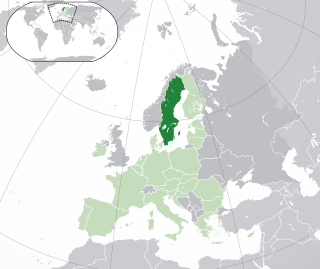
Sweden is a country in Northern Europe on the Scandinavian Peninsula. It borders Norway to the west; Finland to the northeast; and the Baltic Sea and Gulf of Bothnia to the south and east. At 450,295 km2 (173,860 sq mi), Sweden is the largest country in Northern Europe, the fifth largest in Europe, and the 55th largest country in the world.

Tunisia is a country in Northern Africa, bordering the Mediterranean Sea, having a western border with Algeria (965 km) and south-eastern border with Libya (459 km) where the width of land tapers to the south-west into the Sahara. The country has north, east and complex east-to-north coasts including the curved Gulf of Gabès, which forms the western part of Africa's Gulf of Sidra. Most of this greater gulf forms the main coast of Libya including the city of Sirte which shares its root name. The country's geographic coordinates are 34°00′N9°00′E. Tunisia occupies an area of 163,610 square kilometres, of which 8,250 are water. The principal and reliable rivers rise in the north of the country with a few notable exceptions from north-east Algeria and flow through the northern plain where sufficient rainfall supports diverse plant cover and irrigated agriculture.

Guatemala is mountainous, except for the south coastal area and the vast northern lowlands of Petén department. The country is located in Central America and bounded to the north and west by Mexico, to the northeast by Belize and by the Gulf of Honduras, to the east by Honduras, to the southeast by El Salvador, and to the south by the Pacific Ocean. Two mountain chains enter Guatemala from west to east, dividing the country into three major regions: the highlands, where the mountains are located; the Pacific coast, south of the mountains; and the limestone plateau of the Petén region, north of the mountains. These areas vary in climate, elevation, and landscape, providing dramatic contrasts between hot and humid tropical lowlands and highland peaks and valleys.

Iceland is an island country at the confluence of the North Atlantic and Arctic oceans, east of Greenland and immediately south of the Arctic Circle, atop the constructive boundary of the northern Mid-Atlantic Ridge. The island country is the world's 18th largest in area and one of the most sparsely populated. It is the westernmost European country when not including Greenland and has more land covered by glaciers than continental Europe. Its total size is 103,125 km2 (39,817 sq mi) and possesses an exclusive economic zone of 751,345 km2 (290,096 sq mi).

Anseong is a city in Gyeonggi Province, South Korea, 80 kilometres (50 mi) south of Seoul. Its geographical location is 37°0′N127°16′E.
Carol Ann Blazejowski is an American retired professional women's basketball player and the former president and General Manager of the New York Liberty of the Women's National Basketball Association (WNBA). Blazejowski was inducted in the inaugural class at the Women's Basketball Hall of Fame in 1999.
Indira Point, the southernmost point of India's territory, is a village in the Nicobar district at Great Nicobar Island of Andaman and Nicobar Islands in India. It is located in the Great Nicobar tehsil.
The GEOnet Names Server (GNS), sometimes also referred to in official documentation as Geographic Names Data or geonames in domain and email addresses, is a service that provides access to the United States National Geospatial-Intelligence Agency's (NGA) and the US Board on Geographic Names's (BGN) database of geographic feature names and locations for locations outside the US. The database is the official repository for the US Federal Government on foreign place-name decisions approved by the BGN. Approximately 20,000 of the database's features are updated monthly. Names are not deleted from the database, "except in cases of obvious duplication". The database contains search aids such as spelling variations and non-Roman script spellings in addition to its primary information about location, administrative division, and quality. The accuracy of the database had been criticised.

Yuna Kim, also credited in eastern name order as Kim Yuna or Kim Yeon-a, is a retired South Korean competitive figure skater. She is the 2010 Olympic champion, the 2014 Olympic silver medalist, a two-time World champion the 2009 Four Continents champion, a three-time Grand Prix Final champion, the 2006 World Junior champion, the 2005 Junior Grand Prix Final champion, and a six-time South Korean national champion.
In geography, the centroid of the two-dimensional shape of a region of the Earth's surface is known as its geographic centre or geographical centre or gravitational centre. Informally, determining the centroid is often described as finding the point upon which the shape would balance. This method is also sometimes described as the "gravitational method".
The Asia Rugby Championship, or ARC, is an annual rugby union competition held amongst national rugby sides within the Asia Rugby region. The competition was originally known as the Asian Rugby Football Tournament when founded in 1969, and was called the Asian Five Nations from 2008 to 2014.
The Intel Extreme Masters (IEM) is a series of international esports tournaments held in countries around the world. These Electronic Sports League (ESL) sanctioned events, sponsored by Intel, as of 2022 currently host events in Counter-Strike: Global Offensive and StarCraft II. Other game titles were hosted in the past. The body that owns the league is Turtle Entertainment. The League has operated 17 seasons as of 2023. The season finals, with the largest prize pool, takes place in Katowice, Poland. Mid-season events are held in numerous cities around the globe, including Chicago, Shanghai and Sydney.
The following lists include the extreme and significant geographic points of the islands of the Caribbean Sea.

South Korea, officially the Republic of Korea, competed at the 2016 Summer Olympics in Rio de Janeiro, Brazil, from 5 to 21 August 2016. This was the nation's seventeenth appearance at the Olympics. The Korean Olympic Committee sent the nation's smallest ever delegation to the Games in Olympic history since 1984. A total of 205 athletes, 103 men and 101 women, competed in 24 sports.
The 2017 FIFA U-20 World Cup was the 21st edition of the FIFA U-20 World Cup, the biennial international men's youth football championship contested by the under-20 national teams of the member associations of FIFA, since its inception in 1977 as the FIFA World Youth Championship. The tournament was hosted by South Korea from 20 May to 11 June 2017.

Mina Myoi, known mononymously as Mina, is a Japanese singer and dancer based in South Korea. She is one of the three Japanese members of the South Korean girl group Twice, formed by JYP Entertainment in 2015.