
The North Isles are the northern islands of the Shetland Islands, Scotland. The main islands in the group are Yell, Unst and Fetlar. Sometimes the islands in Yell Sound are included in this group.

The Kyrenia Mountains is a long, narrow mountain range that runs for approximately 160 km (100 mi) along the northern coast of the island of Cyprus. It is primarily made of hard crystalline limestone, with some marble. Its highest peak is Mount Selvili, at 1,024 m (3,360 ft). Pentadaktylos is another name for the Kyrenia Mountains, though Britannica refers to Pentadaktylos as the "western portion" of the latter, or the part west of Melounta. Pentadaktylos is so-named after one of its most distinguishing features, a peak that resembles five fingers.

Avalon is a federal electoral district on Newfoundland Island in Newfoundland and Labrador, Canada. It has been represented in the House of Commons of Canada since 2004.

St. John's East is a federal electoral district in Newfoundland and Labrador, Canada, that has been represented in the House of Commons of Canada since 1949.

Dunnet Head is a headland in Highland, on the north coast of Scotland. Dunnet Head includes the most northerly point of both mainland Scotland and the island of Great Britain.
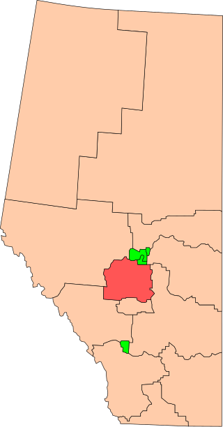
Wetaskiwin was a federal electoral district in Alberta, Canada, that was represented in the House of Commons of Canada from 1925 to 2015.
Hamilton East was a federal electoral district in Ontario, Canada. It was represented in the House of Commons of Canada from 1904 to 2004. It consisted of the eastern part of the city of Hamilton, Ontario. It is considered a working class district.

Saint Andrew is one of eleven parishes of Barbados. It is situated in the northeastern area in the country.

The parish of Saint James is an area located in the western central part of the country of Barbados. Increasingly St. James is becoming known as the playground of the rich and famous, and as a haven for sun-starved tourists with its up-market hotel resorts.
The parish of Saint Lucy is the northernmost area in the country of Barbados. Saint Lucy is the only parish of Barbados out of the eleven to be named after a female patron saint, Saint Lucy of Syracuse. Saint Lucy's shape also resembles a peninsula, surrounded on three sides by the Atlantic Ocean to the north, east and west. The Harrison Point Lighthouse is located in Harrisons, Saint Lucy between Great Head and Norse's Bay, also in Saint Lucy. To the south lies the neighbouring Parish of Saint Peter.

The Parish of Saint Peter is one of eleven parishes in the Caribbean island country of Barbados. It is named after the Christian Apostle and patron saint, Saint Peter. It is located in the north of Barbados, and is the only parish besides Saint Lucy that extends from the east coast to the west.

Willowdale is a federal electoral district in Toronto, Ontario, Canada. It has been represented in the House of Commons of Canada since 1979. It is the riding with the biggest Korean community in Canada. As per the 2021 census, 9.9% of the population of Willowdale is Korean.

Sault Ste. Marie is a federal electoral district in Ontario, Canada, that has been represented in the House of Commons of Canada since 1968.

In the U.S. state of Minnesota, a legislative route is a highway number defined by the Minnesota State Legislature. The routes from 1 to 70 are constitutional routes, defined as part of the Babcock Amendment to the Minnesota State Constitution, passed November 2, 1920. All of them were listed in the constitution until a 1974 rewrite. Though they are now listed separately in §161.114 of the Minnesota Statutes, the definitions are legally considered to be part of the constitution, and cannot be altered or removed without an amendment. Legislative routes with numbers greater than 70 can be added or deleted by the legislature.
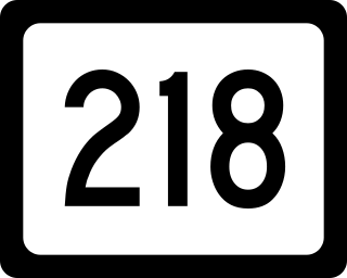
West Virginia Route 218 is a north–south state highway located in Marion and Mononagalia counties in northern West Virginia, United States, that connects U.S. Route 19 (US 19) with the Pennsylvania state line.
The Chittenden-3-3 Representative District is a two-member state Representative district in the U.S. state of Vermont. It is one of the 108 one or two member districts into which the state was divided by the redistricting and reapportionment plan developed by the Vermont General Assembly following the 2000 U.S. Census. The plan applies to legislatures elected in 2002, 2004, 2006, 2008, and 2010. A new plan will be developed in 2012 following the 2010 U.S. Census.

Coolamon Shire is a local government area in the Riverina region of south-western New South Wales, Australia. The Shire comprises 2,433 square kilometres (939 sq mi) and is located adjacent to the Newell Highway and the Burley Griffin Way. The Shire includes the towns of Coolamon, Ganmain, and Ardlethan, and the villages of Matong, Marrar, and Beckom.
Hindmarsh was an electoral district of the House of Assembly in the Australian state of South Australia from 1938 to 1970. It was in the northwestern suburbs of Adelaide.

Sindphana is a minor tributary of Godavari river that originates around the Chincholi hill in Patoda Taluka, Beed District, Maharashtra, in India. Crossing west to east its drainage basin covers nearly 80% of Beed District, making it the most important river within the district. The Majalgaon Dam, constructed across the river, irrigates 93885 hectares of land in Beed, Parbhani & Nanded districts.
Darna is a minor right-bank tributary of Godavari in the Nashik District, Maharashtra, India. Rising north of the Kalsubai range, it drains Igatpuri, Nashik and Niphad Talukas of Nashik District. The conjunction with Godavari is situated at Darnasangvi.
