In situ conservation is the on-site conservation or the conservation of genetic resources in natural populations of plant or animal species, such as forest genetic resources in natural populations of tree species. This process protects the inhabitants and ensures the sustainability of the environment and ecosystem.
India is the world's 8th most biodiverse region with a 0.46 BioD score on diversity index, 102,718 species of fauna and 23.39% of the nation's geographical area under forest and tree cover in 2020. India encompasses a wide range of biomes: desert, high mountains, highlands, tropical and temperate forests, swamplands, plains, grasslands, areas surrounding rivers, as well as island archipelago. Officially, three out of the 36 Biodiversity Hotspots in the world are present in India: the Himalayas, the Western Ghats, and the Indo-Burma region. To these may be added the Sundarbans and the Terrai-Duar Savannah grasslands for their unique foliage and animal species. These hotspots have numerous endemic species. Nearly 5% of India's total area is formally classified under protected areas.

The Himalayan subtropical pine forests are a large subtropical coniferous forest ecoregion covering portions of Bhutan, India, Nepal, and Pakistan.

The Brahmaputra Valley semi-evergreen forests is a tropical moist broadleaf forest ecoregion of Northeastern India, southern Bhutan and adjacent Bangladesh.

Makalu Barun National Park is a national park in the Himalayas of Nepal that was established in 1992 as the eastern extension of Sagarmatha National Park. It is the world's only protected area with an elevation gain of more than 8,000 m (26,000 ft) enclosing tropical forest as well as snow-capped peaks. It covers an area of 1,500 km2 (580 sq mi) in the Solukhumbu and Sankhuwasabha districts, and is surrounded by a bufferzone to the south and southeast with an area of 830 km2 (320 sq mi).

Namdapha National Park is a 1,985 km2 (766 sq mi) large protected area in Arunachal Pradesh of Northeast India. The park was established in 1983. With more than 1,000 floral and about 1,400 faunal species, it is a biodiversity hotspot in the Eastern Himalayas. The national park harbours the northernmost lowland evergreen rainforests in the world at 27°N latitude. It also harbours extensive dipterocarp forests, comprising the northwestern parts of the Mizoram-Manipur-Kachin rain forests ecoregion.

Manas National Park is a national park, Project Tiger reserve, and an elephant reserve in Assam, India. Located in the Himalayan foothills, it borders the Royal Manas National Park in Bhutan. The park is known for its rare and endangered endemic wildlife such as the Assam roofed turtle, hispid hare, golden langur and pygmy hog. Manas is also famous for its population of the wild water buffalo. Because of its exceptional biodiversity, scenery, and variety of habitats, Manas National Park is a biosphere reserve and a UNESCO World Heritage Site.

The Himalayan subtropical broadleaf forests is an ecoregion that extends from the middle hills of central Nepal through Darjeeling into Bhutan and also into the Indian States of Uttar Pradesh and Bihar. It represents the east–west-directed band of subtropical broadleaf forest at an altitude of between 500 and 1,000 m along the Outer Himalayan Range, and includes several forest types traversing an east to west moisture gradient.

The Eastern Himalayan broadleaf forests is a temperate broadleaf forest ecoregion found in the middle elevations of the eastern Himalayas, including parts of Nepal, India, Bhutan, Myanmar and China. These forests have an outstanding richness of wildlife.

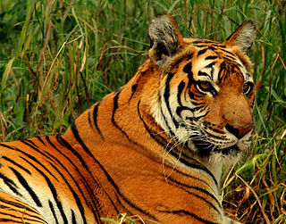
India is one of the most biodiverse regions and is home to a large variety of wildlife. It is one of the 17 megadiverse countries and includes three of the world's 36 biodiversity hotspots – the Western Ghats, the Eastern Himalayas, and the Indo-Burma hotspot.
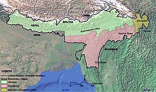
The Eastern Himalayas extend from eastern Nepal across Northeast India, Bhutan, the Tibet Autonomous Region to Yunnan in China and northern Myanmar. The climate of this region is influenced by the monsoon of South Asia from June to September. It is a biodiversity hotspot, with notable biocultural diversity.

The Manas River, known in Bhutan as the Drangme Chhu, is a transboundary river in the Himalayan foothills between southern Bhutan, India, and China. It is the largest of Bhutan's four major river systems, with the other three being the Amo Chu or Torsa River, the Wang Chu or Raidak, and the Puna Tshang Chu or Sankosh. It is met by three other major streams before it again debouches into India in western Assam. The river flows for a total length of 400 kilometres (250 mi), including through Tibet for 24 km (15 mi), Bhutan for 272 kilometres (169 mi), and Assam for 104 kilometres (65 mi) before it joins the mighty Brahmaputra River at Jogighopa. A major tributary of the Manas, the Aie River, joins it in Assam at Bangpari.
Pakke Tiger Reserve, is a Project Tiger reserve in the East Kameng district of Arunachal Pradesh in Northeast India. The 862 km2 (333 sq mi) reserve is protected by the Department of Environment and Forest of Arunachal Pradesh. It was known as Pakhui Tiger Reserve, but renamed in April 2001 by the Governor of Arunachal Pradesh. It has won India Biodiversity Award 2016 in the category of 'Conservation of threatened species' for its Hornbill Nest Adoption Programme.
Hkakaborazi National Park is a national park in northern Myanmar with an area of 1,472 sq mi (3,810 km2). It was established in 1998. It surrounds Hkakabo Razi, the highest mountain in the country.

Jigme Singye Wangchuck National Park covers an area of 1,730 square kilometres (670 sq mi) in central Bhutan. It protects a large area of the Black Mountains, a sub−range of the Himalayan Range System.
Biogeographic classification of India is the division of India according to biogeographic characteristics. Biogeography is the study of the distribution of species (biology), organisms, and ecosystems in geographic space and through geological time. India has a rich heritage of natural diversity. India ranks fourth in Asia and tenth in the world amongst the top 17 mega-diverse countries in the world. India harbours nearly 11% of the world's floral diversity comprising over 17500 documented flowering plants, 6200 endemic species, 7500 medicinal plants and 246 globally threatened species in only 2.4% of world's land area. India is also home to four biodiversity hotspots—Andaman & Nicobar Islands, Eastern Himalaya, Indo-Burma region, and the Western Ghats. Hence the importance of biogeographical study of India's natural heritage.

The Sacred Himalayan Landscape is a 39,021 km2 (15,066 sq mi) large trans-boundary landscape in the eastern Himalayas encompassing temperate broadleaf and conifer forests, alpine meadows and grasslands, which harbour more than 80 mammal and more than 440 bird species. It extends from Nepal's Langtang National Park through Sikkim and Darjeeling in India to western Bhutan's Torsa Strict Nature Reserve. More than 73% of this landscape is located in Nepal, including Sagarmatha National Park, Makalu Barun National Park, and Kanchenjunga Conservation Area. About 24% is located in India, encompassing Khangchendzonga, Singalila and Neora Valley National Parks as well as Fambong Lho, Maenam, Senchal, Mahananda Wildlife Sanctuaries, Shingba and Barsey Rhododendron Sanctuaries and Kyongnosla Alpine Sanctuary.

Raimona National Park is located in extreme western part of Assam, India. It is spread across Gossaigaon and Kokrajhar subdivisions of Kokrajhar district of Bodoland Territorial Region.
In Bhutan there are five national parks and 16 other nature reserves. The protection of nature is under the supervision of the Department of Forests and Park Services of the Department of Agriculture. The protection of the environment and nature is considered to be one of the cornerstones of gross national happiness. Nature reserves take up 48 percent of the kingdom's land area.