
The wildlife of Myanmar includes its flora and fauna and their natural habitats.
The wildlife of Myanmar includes its flora and fauna and their natural habitats.
Like all Southeastern Asian forests, the forests of Myanmar can be divided into two categories: monsoon forest and rainforest. Monsoon forest is dry at least three months a year, and is dominated by deciduous trees. Rainforest has a rainy season of at least nine months, and are dominated by broadleaf evergreen.
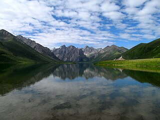
In the region north of the Tropic of Cancer, in the Himalayan region, subtropical broadleaf evergreen dominates to an elevation of 2000 m, and from 2000 m to 3000 m, semi-deciduous broadleaf dominates, and above 3000 m, evergreen conifers and subalpine forest are the primary fauna until the alpine scrubland.
The area from Yangon to Myitkyina is mostly monsoon forest, while peninsular Malaysia south of Mawlamyine is primarily rainforest, with some overlap between the two. Along the coasts of Rakhine State and Tanintharyi Division, tidal forests occur in estuaries, lagoons, tidal creeks, and low islands. These forests are host to the much-depleted Myanmar Coast mangroves habitat of mangrove and other trees that grow in mud and are resistant to sea water. Forests along the beaches consist of palm trees, hibiscus, casuarinas, and other trees resistant to storms.
Myanmar is home to nearly 300 known mammal species, 300 reptile species, and about 1000 bird species. [1] There are also many non-marine molluscs in Myanmar.
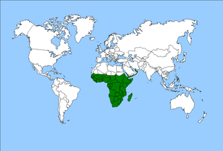
The Afrotropical realm is one of the Earth's eight biogeographic realms. It includes Sub-Saharan Africa, the southern Arabian Peninsula, the island of Madagascar, and the islands of the western Indian Ocean. It was formerly known as the Ethiopian Zone or Ethiopian Region.
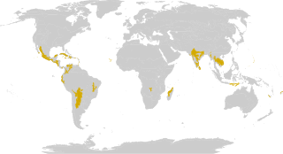
The tropical and subtropical dry broadleaf forest is a habitat type defined by the World Wide Fund for Nature and is located at tropical and subtropical latitudes. Though these forests occur in climates that are warm year-round, and may receive several hundred millimeters of rain per year, they have long dry seasons that last several months and vary with geographic location. These seasonal droughts have great impact on all living things in the forest.

Tropical and subtropical moist broadleaf forests (TSMF), also known as tropical moist forest, is a subtropical and tropical forest habitat type defined by the World Wide Fund for Nature.

The Valdivian temperate forests (NT0404) is an ecoregion on the west coast of southern South America, in Chile and Argentina. It is part of the Neotropical realm. The forests are named after the city of Valdivia. The Valdivian temperate rainforests are characterized by their dense understories of bamboos, ferns, and for being mostly dominated by evergreen angiosperm trees with some deciduous specimens, though conifer trees are also common.

Temperate rainforests are rainforests with coniferous or broadleaf forests that occur in the temperate zone and receive heavy rain.
Laurel forest, also called laurisilva or laurissilva, is a type of subtropical forest found in areas with high humidity and relatively stable, mild temperatures. The forest is characterized by broadleaf tree species with evergreen, glossy and elongated leaves, known as "laurophyll" or "lauroid". Plants from the laurel family (Lauraceae) may or may not be present, depending on the location.
The term Malabar rainforests refers to one or more distinct ecoregions recognized by biogeographers:
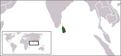
The environment of Sri Lanka exhibits a remarkable biodiversity.

The Odisha semi-evergreen forests are a tropical moist broadleaf forest ecoregion of eastern India. The ecoregion covers an area of 8,600 square kilometers (3,300 sq mi) on the coastal plain of Odisha state, bounded by the Eastern Highlands moist deciduous forests west and north-west, transitioning from the huge ecoregion Lower Gangetic Plains moist deciduous forests along the north coastland, and surrounding the smaller ecoregion Godavari-Krishna mangroves along a stretch of the south-east coast by the Bay of Bengal.

Indo-Burma is a biodiversity hotspot designated by Conservation International.
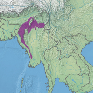
The Mizoram–Manipur–Kachin rain forests is a subtropical moist broadleaf forest ecoregion which occupies the lower hillsides of the mountainous border region joining Bangladesh, China's Yunnan Province, India, and Myanmar. The ecoregion covers an area of 135,600 square kilometres (52,400 sq mi). Located where the biotas of the Indian Subcontinent and the Indochinese Peninsula meet, and in the transition between subtropical and tropical regions of Asia, the Mizoram–Manipur–Kachin rain forests are home to great biodiversity. The WWF rates the ecoregion as "Globally Outstanding" in biological distinctiveness.

The Isthmian–Atlantic moist forests (NT0129) are a Central American tropical moist broadleaf forest ecoregion located on the lowland slopes on the Caribbean Sea side of Nicaragua and Costa Rica and the Gulf and Pacific Ocean sides of Panama. The forest species are a mix of North American and South American, as this region only became a land bridge in the past 3 million years.

The Arnhem Land tropical savanna is a tropical and subtropical grasslands, savannas, and shrublands ecoregion in Australia's Northern Territory.
The flora of China consists of a diverse range of plant species including over 39,000 vascular plants, 27,000 species of fungi and 3000 species of bryophytes. More than 30,000 plant species are native to China, representing nearly one-eighth of the world's total plant species, including thousands found nowhere else on Earth. China's land, extending over 9.6 million km, contains a variety of ecosystems and climates for plants to grow in. Some of the main climates include shores, tropical and subtropical forests, deserts, elevated plateaus and mountains. The events of the continental drift and early Paleozoic Caledonian movement also play a part in creating climatic and geographical diversity resulting in high levels of endemic vascular flora. These landscapes provide different ecosystems and climates for plants to grow in, creating a wide variety of different flora spanning over not just China, but different parts of the world.

Seasonal tropical forest, also known as moist deciduous, semi-evergreen seasonal, tropical mixed or monsoon forest, typically contains a range of tree species: only some of which drop some or all of their leaves during the dry season. This tropical forest is classified under the Walter system as (i) tropical climate with high overall rainfall and (ii) having a very distinct wet season with dry season. These forests represent a range of habitats influenced by monsoon (Am) or tropical wet savanna (Aw/As) climates. Drier forests in the Aw/As climate zone are typically deciduous and placed in the Tropical dry forest biome: with further transitional zones (ecotones) of savannah woodland then tropical and subtropical grasslands, savannas, and shrublands.

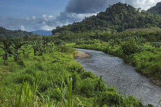
The Myanmar coastal rain forests is a tropical moist broadleaf forest ecoregion on Mainland Southeast Asia. The ecoregion occupies Myanmar's coastal lowlands along the Andaman Sea and the Bay of Bengal.
The Eastern Java-Bali rain forests ecoregion covers the lowland areas of the eastern half of the island of Java, and the island of Bali, in Indonesia. This ecoregion is distinct from the Eastern Java-Bali montane rain forests, which exists at higher elevations where mountain forest habitat dominates. Very little of the natural lowland rainforest remains in its pre-human settlement state.

The Trinidad and Tobago moist forests ecoregion covers most of Trinidad Island and Tobago Island near the coast of South America where the southeastern Caribbean Sea meets the Atlantic Ocean. Small portions of the islands around river estuaries and coastal lowlands are mangroves or dry forests. Species diversity is very high, in particular for plants and birds. Tobago, being much smaller, has fewer species.
Sri Lanka exhibits a remarkable biological diversity and is considered to be the richest country in Asia in terms of species concentration.

Rainforests and vine thickets are a major vegetation group in Australia. It consists of temperate to tropical rainforests, monsoon forests, and vine thickets. Rainforests and vine thickets are generally found in small pockets across the eastern and northern portions of the continent, including western Tasmania, eastern New South Wales, eastern Queensland, the northern portion of the Northern Territory, and the Kimberley Region of northeastern Western Australia.
| Sovereign states |
|
|---|---|
| States with limited recognition | |
| Dependencies and other territories | |