List of rivers of Mongolia

Last updated

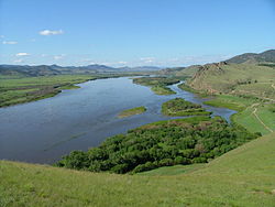
Gorge of the Chuluut River ChuluutCanyon.JPG
Gorge of the Chuluut River

This is a list of notable rivers of Mongolia , arranged geographically by river basin.

Contents

The Mongolian words for river are gol (гол) and mörön (мөрөн), with the latter usually used for larger rivers. The Mongolian names also occasionally have a genitive construction, with the name of the river having the suffix -iin (-ийн) or -yn (-ын). For example, the Ider River's Mongolian name is Ideriin gol (Идэрийн гол), equivalent to saying "the river of Ider".
Longest rivers

  1. Orkhon River - 1,124 kilometres (698 mi)
  2. Kherlen River - 1,090 kilometres (677 mi)
  3. Tuul River - 704 kilometres (437 mi)
  4. Zavkhan River - 670 kilometres (416 mi)
  5. Selenge River - 593 kilometres (368 mi)
  6. Hovd River - 516 kilometres (321 mi)
  7. Eg Riverпп - 475 kilometres (295 mi)
  8. Ider River - 452 kilometres (281 mi)
  9. Delgermörön - 445 kilometres (277 mi)

Flowing into the Arctic Ocean

Selenge River Selenga2.jpg
Selenge River
Ider River IderiinGol.JPG
Ider River
Tuul River Tuul River Mongolia.JPG
Tuul River
Shishged River ShishgedGol.JPG
Shishged River

Flowing into the Sea of Okhotsk (Pacific Ocean)

Flowing into endorheic basins

Hulun Lake

Ulaan Lake

Great Lakes Depression

Khar-Us Lake

Uvs Nuur Basin

Uvs Lake and basin Uvs Nuur drainage basin.jpg
Uvs Lake and basin

Rivers draining into endorheic Uvs Lake, forming the drainage of the Uvs Lake Basin

Khyargas Lake

Dörgön Lake

  • Teeliin gol, flowing out of Khar Lake
    • Chono Kharaikh gol, draining into Khar Lake

Ulungur Lake

Related Research Articles

<span class="mw-page-title-main">Geography of Mongolia</span>

Mongolia is a landlocked country in East Asia, located between China and Russia. The terrain is one of mountains and rolling plateaus, with a high degree of relief. The total land area of Mongolia is 1,564,116 square kilometres. Overall, the land slopes from the high Altai Mountains of the west and the north to plains and depressions in the east and the south. The Khüiten Peak in extreme western Mongolia on the Chinese border is the highest point. The lowest point is at 560 m (1,840 ft), is the Hoh Nuur or lake Huh. The country has an average elevation of 1,580 m (5,180 ft).

Articles related to Mongolia include:

<span class="mw-page-title-main">Orkhon River</span> River in Mongolia

The Orkhon River is a river in Mongolia.

<span class="mw-page-title-main">Selenga</span> River in Mongolia and Russia

The Selenga or Selenge is a major river in Mongolia and Buryatia, Russia. Originating from its headwater tributaries, the Ider and the Delger mörön, it flows for 992–1,024 kilometres (616–636 mi) before draining into Lake Baikal. The Selenga therefore makes up the most distant headwaters of the Yenisey-Angara river system.

<span class="mw-page-title-main">Provinces of Mongolia</span> First-level administrative divisions of Mongolia

Mongolia is divided into 21 provinces or aimags and one provincial municipality. Each aimag is subdivided into several districts. The modern provinces have been established since 1921. The capital, Ulaanbaatar, is governed as an independent provincial municipality separate from Töv Province, inside which it is situated.

<span class="mw-page-title-main">Bulgan Province</span> Province of Mongolia

Bulgan is one of the 21 aimags (provinces) of Mongolia, located in northern Mongolia. Its capital is also named Bulgan.

<span class="mw-page-title-main">Argun (Amur)</span> River in Russia and China

The Argun or Ergune is a 1,620-kilometre (1,010 mi) long river that forms part of the eastern China–Russia border, together with the Amur. Its upper reaches are known as Hailar River in China. The Argun marks the border between Russia and China for about 944 kilometres (587 mi), until it meets the Amur.

Bayan may refer to:

<span class="mw-page-title-main">Lake Khövsgöl</span> Largest freshwater lake in Mongolia

Lake Khövsgöl is a lake in Khövsgöl Province, Mongolia. It is the largest freshwater lake in the country by volume and second largest by area after Uvs Lake. It is nicknamed the "Younger sister" of those two "sister lakes".

The Khangai Mountains ; form a range in central Mongolia, some 400 km (250 mi) west of Ulaanbaatar.

<span class="mw-page-title-main">Khanui River</span> River in Mongolia

Khanui River is a river flowing down through the valleys of the Khangai Mountains in central Mongolia. It starts in the Chuluut sum of Arkhangai aimag at the north slopes of the Khan-Öndör mountain. It passes next to the center of Erdenemandal sum, and ends in the Khutag-Öndör sum of Bulgan aimag where it discharges into the Selenge. It is 421 kilometres (262 mi) long, and has a drainage basin of 14,600 square kilometres (5,600 sq mi).

<span class="mw-page-title-main">Tamir River</span> River in Mongolia

The Tamir is a river flowing through the valleys of the Khangai Mountains in the Arkhangai aimag of central Mongolia. The river is the namesake of the Mongolian literature classic by Chadraabalyn Lodoidamba, The Clear Tamir River.

<span class="mw-page-title-main">Tuul River</span> River in Mongolia

The Tuul River or Tula River is a river in central and northern Mongolia. Sacred to the Mongols, the Tuul is generally called the Hatan Tuul. It is 882.8 kilometres or 549 miles long and drains an area of 49,840 square kilometres or 19,240 square miles. The Secret History of the Mongols frequently mentions a "Black Forest of the Tuul River" where the palace of Ong Khan was located.

<span class="mw-page-title-main">Districts of Mongolia</span> Administrative subdivision of Mongolia

A district, is a second level administrative subdivision of Mongolia. The 21 provinces of Mongolia are divided into 330 sum.

<span class="mw-page-title-main">Kherlen River</span> River in China and Mongolia

Kherlen River is a 1,254 km river in Mongolia and China. It is also one of the two longest rivers in Mongolia, along with the Orkhon River.

The Delger mörön is a river in the Khövsgöl aimag in northern Mongolia. It rises in the Ulaan Taiga range close to the Russian border. It is 445 kilometres (277 mi) long, and has a drainage basin of 26,600 square kilometres (10,300 sq mi).

<span class="mw-page-title-main">Ider River</span> River in Mongolia

The Ider River is a river in the Khövsgöl and Zavkhan aimags in northwestern Mongolia and is, together with the Delger mörön river, one of the sources of the Selenga river. It is 452 kilometres (281 mi) long, and has a drainage basin of 24,600 square kilometres (9,500 sq mi). The source is in the Khangai range, the confluence with the Delgermörön is in Tömörbulag. The river is frozen 170–180 nights per year. There is a wooden bridge, which was built in 1940, near Jargalant and a concrete bridge in Galt.

<span class="mw-page-title-main">Egiin Gol</span> River in Mongolia

The Egiin Gol is a river in the Khövsgöl and Bulgan aimags in northern Mongolia. It is the only outflow of Lake Khövsgöl and a left tributary of the Selenge river. It is 475 kilometres (295 mi) long, and has a drainage basin of 49,100 square kilometres (19,000 sq mi). Wooden bridges exist near Khatgal and in Tünel sum, and a concrete bridge has been built in Erdenebulgan. In Bulgan aimag there is a bridge between Teshig and Khutag-Öndör sums.

<span class="mw-page-title-main">Tes River</span> River in Mongolia and Russia

The Tes River is a river in northwestern Mongolia and southern Tuva, Russia. Its spring is in Tsagaan-Uul sum in Khövsgöl. The river then flows through Zavkhan (Mongolia), Tuva (Russia), next back to Uvs (Mongolia) before entering Uvs Lake. While in Khövsgöl, there is a wooden bridge near Tsetserleg and a concrete bridge near Bayantes on the road to Kyzyl, Russia.

<span class="mw-page-title-main">Great Lakes Depression</span>

The Great Lakes Depression, also called the Great Lakes' Hollow, is a large semi-arid depression in Mongolia that covers parts of the Uvs, Khovd, Bayan-Ölgii, Zavkhan and Govi-Altai aimags. Bounded by the Altai in the West, Khangai in the East and Tannu-Ola Mountains in the North, it covers the area of over 100,000 km2 (39,000 sq mi) with elevations from 750 to 2,000 m (2,460–6,560 ft).