List of national parks of Mongolia

Last updated

#NamePhotoLocationMapArea (km2)YearDescription
1 Altai Tavan Bogd
Tavan Bogd Mountain.jpg
Bayan-Ölgii Province
48°33′N88°37′E / 48.550°N 88.617°E / 48.550; 88.617
Relief map of Mongolia.png
Red pog.svg
63621996Located in the Altai Mountains at the western extreme of Mongolia, the park ("Altai five saints nature complex") includes Tavan Bogd, the highest mountain in Mongolia. Within the park is The (UNESCO) World Heritage Site 'Petroglyphic Complexes of the Mongolian Altai'. [1] [2]
2 Gobi Gurvansaikhan
Gurvger.jpg
SouthGobi Province
43°N104°E / 43°N 104°E / 43; 104
Relief map of Mongolia.png
Red pog.svg
269471993The park (Gobi three beauties nature complex) is located in the Gurvan Saikhan Mountains, in the Gobi Desert of south central Mongolia. It is the largest national park in Mongolia. Landmarks include Khongoryn Els, the "Singing Sands", a large complex of sand dunes that reach to the southeastern Altai Mountains. [3]
3 Gorkhi-Terelj
Gorchi-Tereldsch8.JPG
Töv Province
48°09′N107°34′E / 48.150°N 107.567°E / 48.150; 107.567
Relief map of Mongolia.png
Red pog.svg
29321993Gorkhi-Terelj is located 37 km east of the capital city of Ulaanbaatar. Attractions include Khagiin Khar Lake, a 20m deep glacial lake 80 km upstream from the tourist camps, and Yestii Hot Water Springs, natural hot springs 18 km further upstream. The park also has a Buddhist monastery that is open to visitors. [4]
4 Khustain Nuruu
PrezHorseHustai.jpg
Töv Province
47°46′N105°53′E / 47.767°N 105.883°E / 47.767; 105.883
Relief map of Mongolia.png
Red pog.svg
5061993(Also called "Hustai Nuruu" (Birch Mountains), the park is located about 70 km west of Ulaanbaatar in central Mongolia. It is situated in steppe terrain along the Khentii Mountains, with the Tuul River flowing through its borders. It is part of the UNESCO Man and Biosphere site "Husai Nuruu", and is supporting the reintroduction of the endangered Przewalski's horse. [5] [6]
5 Lake Khövsgöl
View from Hovsgol Lake to Munku-Sardyk - panoramio.jpg
Khövsgöl Province
51°12′N100°50′E / 51.200°N 100.833°E / 51.200; 100.833
Relief map of Mongolia.png
Red pog.svg
83811992The park covers territory surrounding Lake Khovsgul, the largest freshwater lake in Mongolia (over 1,000 square miles and averaging over 450 feet in depth). Located in northwestern Mongolia on the border with Russia, Lake Khovsgul is sometimes referred to as a "younger sister" of Lake Baikal to the north. [7]
6 Khyargas Nuur
Khyargas-Nuur lake, Uvs aimag, Mongolia.JPG
Khovd Province
47°58′N92°50′E / 47.967°N 92.833°E / 47.967; 92.833
Relief map of Mongolia.png
Red pog.svg
85031997 Khyargas Nuur is a large (1,481 km2) salt lake in the Great Lakes Basin of western Mongolia, surrounded by desert and scrub. It is half-way between Uvs Lake, 70 km to the north, and Har Us Nuur National Park, 70 km to the south. The lake is known for hot springs. [8]
7 Tarvagatai Nuruu
Prostration Boards Facing Otgontenger Mountain - Zavkhan Aimag, Mongolia.JPG
Zavkhan Province
48°00′N97°30′E / 48°N 97.5°E / 48; 97.5
Relief map of Mongolia.png
Red pog.svg
65762000The park covers the southwestern sector of the Tarvagatai Range of the Khangai Mountains in central Mongolia. The park is remote, protecting a transition zone between semi-arid steppe to the south and coniferous forests on the northern slope of the range. A large fire burned a significant part of the park in 2002, including 800 square kilometres (310 sq mi) of forest. [9]
8 Tsambagarav Uul
Tsambagarav Mountain.JPG
Bayan-Ölgii Province
48°42′N91°00′E / 48.7°N 91°E / 48.7; 91
Relief map of Mongolia.png
Red pog.svg
11372000Mt Tsambagarav is a stand-alone mountain of the Mongol Altai Mountains, rising to an elevation of 4,193 metres (13,757 ft). The park features glaciers, rocky gorges, and glacial lakes. [10]
9 Bulgan Gol-Ikh Ongog
Bulgan gol.jpg
Bayan-Ölgii Province
46°06′N91°10′E / 46.1°N 91.16°E / 46.1; 91.16
Relief map of Mongolia.png
Red pog.svg
9272011The Bulgan River divides into many meandering streams, lakes, and wetlands as if flow through the valley in the park. The area is an important stopover for migratory birds. Species in the park include the vulnerable eastern imperial eagle, and the lesser kestrel. [11] [12]
10Chigertein Golin Ai Sav Bayan-Ölgii Province
47°48′N90°15′E / 47.8°N 90.25°E / 47.8; 90.25
Relief map of Mongolia.png
Red pog.svg
16722012The Chigertey River Valley is a 20-mile wide glacial valley west of Delüünin the Altai Mountains on Mongolia's western border with China. Larch forests grow on the northern slopes of the mountains from elevations of 2,400-2,800 meters. [13] [14]
11Dariganga
Dariganga.jpg
Sükhbaatar Province
45°15′N114°00′E / 45.25°N 114.0°E / 45.25; 114.0
Relief map of Mongolia.png
Red pog.svg
6452004The park is on the Dariganga Plateau in southeastern Mongolia. Both Gobi desert and steppe habitats are featured around Ganga Lake. The site is a Ramsar Convention wetland of international importance, supporting breeding and migratory waterbirds such as the vulnerable white-naped crane and the vulnerable great bustard. [15] [16] [17]
12 Har Us Nuur
Jargalant Mountain2.JPG
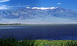
Khovd Province
48°18′N92°44′E / 48.3°N 92.74°E / 48.3; 92.74
Relief map of Mongolia.png
Red pog.svg
85031997The park is centered on Khar-Us Lake, Khar Lake and Dörgön Lake in the Great Lakes Basin of western Mongolia. [18] [19]
13 Ikh Bogd Uul
Ikh Bogd Uul mount, Gobian Altay range, Bayankhongor aimag, Mongolia, 2006 (Highest point).jpg
Bayankhongor Province
45°00′N100°18′E / 45°N 100.3°E / 45; 100.3
Relief map of Mongolia.png
Red pog.svg
26292008 Ikh Bogd ("Great Saint") is the highest mountain in the Altai-Gobi Mountains, a southeastern spur range of the Altai. The middle and high elevations feature alpine meadows and montane steppe. The range, with semi-arid deserts to the north and south, supports rare species, such as the near-threatened argali ( Ovis ammon ) and Pallas's cat ( Otocolobus manul ). [20] [21]
14 Khangai Nuruu
Kharkhorin3.JPG
Arkhangai Province
47°12′N101°24′E / 47.2°N 101.4°E / 47.2; 101.4
Relief map of Mongolia.png
Red pog.svg
88851996The park stretches across the middle ranges of the greater Khangai Mountains in west-central Mongolia. In the northeastern area of the park is the famous Tövkhön Monastery. [22]
15 Khan-Khokhi Khyargas Mountain
Zuunkhangai.jpg
Uvs Province
49°25′N94°47′E / 49.42°N 94.79°E / 49.42; 94.79
Relief map of Mongolia.png
Red pog.svg
34132000The Khan-Khokhi mountains are a western extension of the Khangai Mountains in Uvs Province. The mountains separate the Uvs Depression to the north from the Khyargas Lake depression to the south. The Khan-Khokhii National Park is a separate territory from that of Khyargas Nuur National Park, 20 km to the south. [23]
16 Khorgo-Terkhiin Tsagaan Nuur
Terkhijn Tsagaan Nuur1 - panoramio.jpg
Arkhangai Province
48°12′N99°48′E / 48.2°N 99.8°E / 48.2; 99.8
Relief map of Mongolia.png
Red pog.svg
7731965The park is centered on Terkhiin Tsagaan Lake, a freshwater lake in the Khangai Mountains, and the nearby Khorgo volcano (extinct). [24]
17Mongol Els Zavkhan Province
47°36′N94°42′E / 47.6°N 94.7°E / 47.6; 94.7
Relief map of Mongolia.png
Red pog.svg
27132010This particular "Mongolian Sands" National Park is about 100 km southeast of Khar Lake (Khovd). It covers a sand deposit 300 km long across the Zavkhan River valley. [25] [26]
18 Munkhkhairkhan
Balbal at Munkh-Khairkhan mount - panoramio.jpg
Bayan-Ölgii Province
47°00′N92°30′E / 47°N 92.5°E / 47; 92.5
Relief map of Mongolia.png
Red pog.svg
50612011The park is centered on Mönkhkhairkhan Mountain, the second highest mountain in Mongolia. [27]
19Myangan-Ugalzat Khovd Province
46°18′N93°12′E / 46.3°N 93.2°E / 46.3; 93.2
Relief map of Mongolia.png
Red pog.svg
30382011The park covers a sector high desert steppe of the Mongol Altai Mountains in western Mongolia. The park was established to protect its populations of the vulnerable Altai argali (Ovis ammon ammon). [28] [29] [30]
20Noyon Khangai
Arkhangai Khangai sum Naadam - panoramio.jpg
Arkhangai Province
47°45′N99°30′E / 47.75°N 99.50°E / 47.75; 99.50
Relief map of Mongolia.png
Red pog.svg
5911998The Noyon Khangai Mountains are a range in the south-central region of the greater Khangai Mountains. There are geothermal hot springs in the area at an altitude of 2,300 metres (7,500 ft). [31] [32]
21 Onon-Balj
OnonRiver.jpg
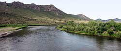
Khentii Province
48°59′N111°06′E / 48.98°N 111.1°E / 48.98; 111.1
Relief map of Mongolia.png
Red pog.svg
41482000Onon-Balj covers the confluence of the Onon River and Balj River in Dadal Soum of Khentii Province. The area features many rivers, lakes, and desert steppe terrain. [33]
22 Orkhon Valley
Orchon28.JPG
Övörkhangai Province
47°27′N102°43′E / 47.45°N 102.72°E / 47.45; 102.72
Relief map of Mongolia.png
Red pog.svg
35302006Valley of the Orkhon River east of the Khangai Mountains, on pastureland, and with many historical and archaeological sites. The site of Kharkhorum, the capital of Genghis Khan's 13th-century empire. A UNESCO World Heritage Site ('Orkhon Valley Cultural Landscape'), and UICN protected area ('Orxoni Xundii'). [34] [35]
23Siilxem Nuruu
Climbing Nariinii Ehin Mount - panoramio.jpg
Bayan-Ölgii Province
49°44′N89°52′E / 49.74°N 89.87°E / 49.74; 89.87
Relief map of Mongolia.png
Red pog.svg
8812000Spread across two separate sectors along the border with Russia in the Siilkhem Mountains, northeast of Altai Tavan Bogd. Sector 'A' is the northernmost range of the Altai argali and Sector 'B' is habitat for the snow leopard. [36] [37]
24Tengis-Shishged Khövsgöl Province
51°29′N98°44′E / 51.49°N 98.73°E / 51.49; 98.73
Relief map of Mongolia.png
Red pog.svg
87572000The park covers the lower Shishged River as if flows west from the Darkhad Valley in northern Mongolia. The landscape is one of high peaks with steep sides and wide glaciated valleys. It protects a cultural region of the Dukha people, nomadic reindeer herders. [38] [39]
25Tujiin Nars
Selenge Altanbulag tujiin nars - panoramio.jpg
Selenge Province
50°06′N106°24′E / 50.1°N 106.4°E / 50.1; 106.4
Relief map of Mongolia.png
Red pog.svg
7082002Tujiin Nars is a pine forest in Selenge Province, in northern Mongolia. An extensive reforestation effort is underway in the park, recovering from forest fires and illegal logging in the 1990s. [40] [41] [42]
26 Ulaagchini Khar Nuur
Ulaagchinii Khar lake - panoramio.jpg
Zavkhan Province
48°22′N95°37′E / 48.37°N 95.62°E / 48.37; 95.62
Relief map of Mongolia.png
Red pog.svg
25942010The park encompasses two large freshwater lakes, Bayan Lake to the west, and Ulaagchin Khar Lake 50 km to the east. This is the 'Khar Lake' in Zavkhan Province located in a depression below the Tarvagatai Mountains. Ulaagchin Khar is surrounded by sand dunes and mountains. [43] [44]
27Undurkhaan Uul Khentii Province
47°30′N110°27′E / 47.5°N 110.45°E / 47.5; 110.45
Relief map of Mongolia.png
Red pog.svg
882012The site is small, covering an isolated mountain surrounded by low areas, about 25 km north of Öndörkhaan. [45]
28 Khugnu-Tarna
Rashaant, Mongolia - panoramio (9).jpg
Bulgan Province
47°28′N103°38′E / 47.47°N 103.64°E / 47.47; 103.64
Relief map of Mongolia.png
Red pog.svg
8412003Khogno Khan Mountain is about 60 km east of Kharakoram. The park features many historical sites, including the ruins of a 17th-century monastery. [46]
29Zag Baidragiin Goliin Ekhen Sav Bayankhongor Province
47°30′N99°28′E / 47.5°N 99.46°E / 47.5; 99.46
Relief map of Mongolia.png
Red pog.svg
11632012The park covers valleys of the Baidrag River and Zag River as they flow south from the Khangai Mountains in west-central Mongolio. [47]

Related Research Articles

Articles related to Mongolia include:

<span class="mw-page-title-main">Flag of Mongolia</span> National flag

The national flag of Mongolia is a vertical triband with a red stripe at each side and a blue stripe in the middle, with the Mongolian Soyombo symbol centering on the leftmost stripe. The blue stripe represents the eternal blue sky, and the red stripes thriving for eternity. The Soyombo symbol is a geometric abstraction that represents fire, sun, moon, earth, water, and a Taijitu symbol representing the duality of yin and yang.

<span class="mw-page-title-main">Bayan-Ölgii Province</span> Westernmost Mongolian province

Bayan-Ölgii is the westernmost of the 21 aimags (provinces) of Mongolia. The country's only Muslim and Kazakh-majority aimag, it was established in August 1940. Its capital is Ölgii.

<span class="mw-page-title-main">Bayankhongor Province</span> Province (aimag) of Mongolia

The Bayankhongor Province or Bayanhongor Aimag is one of the 21 aimags (provinces) of Mongolia. It is located in the southwest of the country and, at 116,000 square kilometers, it is one of the largest aimags. The capital of the aimag shares the provincial name, Bayankhongor.

<span class="mw-page-title-main">Khovd Province</span> Mongolian province

Khovd is one of the 21 aimags (provinces) of Mongolia, located in the west of the country. Its capital is also named Khovd.

<span class="mw-page-title-main">Zavkhan Province</span> Mongolian province

Zavkhan is one of the 21 aimags (provinces) of Mongolia, located in the west of the country, 1,104 km from Ulaanbaatar. Its capital is Uliastai. The aimag is named after the Zavkhan River, which forms the border between Zavkhan and Gobi-Altai aimag.

<span class="mw-page-title-main">Tavan Bogd</span> Mongolian mountain

The Tawan Bogd is a mountain massif in Mongolia, near the triple border with China and Russia. Its highest peak, the Khüiten Peak, is the highest point of Mongolia at 4374 meters above sea level.

<span class="mw-page-title-main">Districts of Mongolia</span> Administrative subdivision

A district, is a second level administrative subdivision of Mongolia. The 21 provinces of Mongolia are divided into 330 sum.

<span class="mw-page-title-main">Mongolian–Manchurian grassland</span> Ecoregion in East Asia

The Mongolian-Manchurian grassland, also known as the Mongolian-Manchurian steppe or Gobi-Manchurian steppe, in the temperate grassland biome, is an ecoregion in East Asia covering parts of Mongolia, the Chinese Autonomous region of Inner Mongolia, and Northeast China.

<span class="mw-page-title-main">Great Lakes Depression</span>

The Great Lakes Depression, also called the Great Lakes' Hollow, is a large semi-arid depression in Mongolia that covers parts of the Uvs, Khovd, Bayan-Ölgii, Zavkhan and Govi-Altai aimags. Bounded by the Altai in the West, Khangai in the East and Tannu-Ola Mountains in the North, it covers the area of over 100,000 km2 (39,000 sq mi) with elevations from 750 to 2,000 m (2,460–6,560 ft).

<span class="mw-page-title-main">Hustai National Park</span>

Hustai National Park, located in the Khustai Mountains of Töv Province (Aimag), is a national park of Mongolia. It is also known as Khustain Nuruu National Park. The Tuul River runs through the park.

<span class="mw-page-title-main">Altai Tavan Bogd National Park</span>

Altai Tavan Bogd National Park is a national park in Bayan-Ölgii Province of western Mongolia. The park includes the Mongolian side of the Tavan Bogd massif, which is divided by the triple border with Russia and China in the Altai Mountains.

Ikh Bogd, also known as Tergun Bogd, is the highest mountain of the Gobi-Altai Mountains and located in the Bayankhongor Province in Mongolia. It has an elevation of 3,957 metres (12,982 ft)

<span class="mw-page-title-main">Wildlife of Mongolia</span>

The wildlife of Mongolia consists of flora, fauna and funga found in the harsh habitats dictated by the diverse climatic conditions found throughout the country. In the north, there are salty marshes and fresh-water sources. The centre has desert steppes. In the south, there are semi deserts as well as the hot Gobi desert in the south, the fifth-largest desert in the world.

<span class="mw-page-title-main">Altai alpine meadow and tundra</span> Ecoregion in the Altai Mountains

The Altai alpine meadow and tundra ecoregion is a terrestrial ecoregion covering the higher elevation of the Altai Mountains at the center of the "X" formed by the borders separating Russia, Kazakhstan, China, and Mongolia. The mountain peaks are the farthest north in Central Asia, separating the plains of Siberia to the north from the hot, dry deserts to the south. Altitudes above 2,400 meters display characteristics of tundra, with patches of alpine meadows and some trees immediately below the treeline. The ecoregion is in the montane grasslands and shrublands biome, and the Palearctic realm, with a humid continental climate. It covers an area of 90,132 square kilometres (34,800 sq mi).

<span class="mw-page-title-main">Har Us Nuur National Park</span>

Har Us Nuur National Park covers a chain of three large lakes in the Great Lakes Basin of western Mongolia. The lakes, Khar-Us Nuur, Khar Lake and Dörgön Lake are bordered by marshes and reed-beds that are an important breeding sport for birds, over 200 species of which have been identified in the park. Mount Jargalant is on the southern shore of Khar-Us. This park is distinct from Khyargas Nuur National Park, another large lake in the region, but 60 km to the north.

<span class="mw-page-title-main">Ikh Bogd Uul National Park</span>

Ikh Bogd Uul National Park is centered on Ikh Bogd, the highest mountain in the Altai-Gobi Mountains, a southeastern spur range of the Altai. The middle and high elevations feature alpine meadows and montane steppe. The range, with semi-arid deserts to the north and south, supports rare species, such as the near-threatened argali and Pallas's cat.

<span class="mw-page-title-main">Bulgan Gol-Ikh Ongog National Park</span>

Bulgan Gol-Ikh Ongog National Park is centered on the Bulgan River, which divides into many meandering streams, lakes, and wetlands as if flow through the valley in the park. The area is an important stopover for migratory birds. Species in the park include the vulnerable eastern imperial eagle, and the lesser kestrel.

<span class="mw-page-title-main">Ulaagchinii Khar Nuur National Park</span>

Ulaagchinii Khar Nuur National Park is centered on two large freshwater lakes, Bayan Lake to the west, and Ulaagchin Khar Lake 50 km to the east, in west-central Mongolia. The particular 'Khar Lake' of this park is in Zavkhan Province, located in a depression west of the Tarvagatai Mountains. Ulaagchin Khar is surrounded by sand dunes and mountains.

<span class="mw-page-title-main">Dayan Lake</span>

Dayan Lake is a lake located the district of Sagsai, in the Bayan-Ölgii Province of western Mongolia. It is recognized by BirdLife International as an Important Bird Area since 2009. It is located in the Altai Tavan Bogd National Park.

References

  1. "Petroglyphic Complexes of the Mongolian Altai". UNESCO. Retrieved April 11, 2020.
  2. "Altai Tavan range". Protected Planet. Retrieved April 11, 2020.
  3. "Gobi Gurvansaikhan range". Protected Planet. Retrieved April 11, 2020.
  4. "Gorkhi - Terelj". Protected Planet. Retrieved April 11, 2020.
  5. "Hustai Nuruu". UNESCO Man and Biosphere Program. Retrieved April 11, 2020.
  6. "Hustain Nuruu". Protected Planet. Retrieved April 11, 2020.
  7. "Kuvsgul National Park". Protected Planet. Retrieved April 11, 2020.
  8. "Khan Khukhii-Khyragas Lake". Protected Planet. Retrieved April 25, 2020.
  9. "Tarvagatai National Park". Protected Planet. Retrieved April 11, 2020.
  10. "Cambagary National Park". Protected Planet. Retrieved April 11, 2020.
  11. "Bulgan gol-Ikh Ongog". Protected Planet. Retrieved April 11, 2020.
  12. "Bulgan gol-Ikh Ongog". BirdLife International. Retrieved April 11, 2020.
  13. "Chigrtein". Protected Planet. Retrieved April 11, 2020.
  14. "Reconstructing Late Holocene Climate Through Tree-Ring Analysis of Siberian Larch: Altai Mountains, Western Mongolia" (PDF). Keck Geology Consortium . Retrieved April 18, 2020.
  15. "Dariganga". Protected Planet. Retrieved April 11, 2020.
  16. "Dariganga". BirdLife International. Retrieved April 11, 2020.
  17. "Lake Ganga and its surrounding wetlands". Ramsar Sites Information Service. Retrieved April 11, 2020.
  18. "Khar-Us Nuur National Park". BirdLife International. Retrieved April 25, 2020.
  19. "Khar Us Nuur National Park". Ramsar Convention. Retrieved April 25, 2020.
  20. "Ix Bogd mountain". Protected Planet. Retrieved April 11, 2020.
  21. "Ikh Bogd Mountain". BirdLife International. Retrieved April 18, 2020.
  22. "Kangai nuruu". Protected Planet. Retrieved April 11, 2020.
  23. "Khan-Khokhi". Protected Planet. Retrieved April 11, 2020.
  24. "Khorgo Terkh Zagaan nuur". Protected Planet. Retrieved April 11, 2020.
  25. "Mongol Els". Protected Planet. Retrieved April 11, 2020.
  26. "Mongolian sand natural monument" (in Mongolian). Department of Nature and Environment of Gobi-Altai aimag. Retrieved April 18, 2020.
  27. "Munkh-Khairkhan". Protected Planet. Retrieved April 11, 2020.
  28. "Myangan Ugalzataa". Protected Planet. Retrieved April 11, 2020.
  29. "Myangan Ugalzat" (in Mongolian). Official Park Website. Retrieved April 11, 2020.
  30. "Myangan Ugalzat" (in Mongolian). Park Administrator. Retrieved April 18, 2020.
  31. "Noyon Khangai". Protected Planet. Retrieved April 11, 2020.
  32. "Thermoeconomic Analysis of a New Geothermal Utilization CHP Plant in Tsetserleg, Mongolia" (PDF). The United Nations University. Retrieved April 18, 2020.
  33. "Onon - Balj - A". Protected Planet. Retrieved April 11, 2020.
  34. "Orxoni Xundii". Protected Planet. Retrieved April 11, 2020.
  35. "Orkhon Valley Cultural Landscape". UNESCO. Retrieved April 18, 2020.
  36. "Siilxem". Protected Planet. Retrieved April 11, 2020.
  37. "Tentative List - Highlands of Mongol Altai". UNESCO World Heritage. Retrieved April 18, 2020.
  38. "Tengis-Shishged". Protected Planet. Retrieved April 11, 2020.
  39. "Natural Resource Inventory and Monitoring for Ulaan Taiga Specially Protected Areas" (PDF). US Geological Survey. Retrieved April 18, 2020.
  40. "Tujiin Nars". Protected Planet. Retrieved April 11, 2020.
  41. "Tujiin Nars National Park" (in Mongolian). Official Park Facebook site. Retrieved April 18, 2020.
  42. Bowman, Julie (September 1, 2012). "Tujin Nars: A Story of the Forest". SIT Digital Collectins. SIT Graduate Institute. Retrieved April 18, 2020.
  43. "Ulaagchini Khar Nuur". Protected Planet. Retrieved April 11, 2020.
  44. "Khar Lake Important Bird Area". BirdLife International. Retrieved April 18, 2020.
  45. "Undurkhaan Uul". Protected Planet. Retrieved April 18, 2020.
  46. "Xugnu Tarna". Protected Planet. Retrieved April 11, 2020.
  47. "Zag Baidragiin goliin ekhen sav". Protected Planet. Retrieved April 11, 2020.