Contents


Jebel Ali is a port town 35 kilometers (22 mi) south-west of Dubai. The Jebel Ali Port is located there. Al Maktoum International Airport has been constructed just outside the port area. Jebel Ali is connected to Dubai via the UAE Exchange, Danube and Energy stations on the Dubai Metro. Among the infrastructure projects built to support the port and town is the world's largest desalination plant, the Jebel Ali Desalination Plant, providing an ample supply of freshwater.

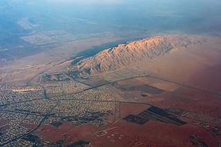
Jabal Hafeet is a mountain in the region of Tawam, on the border of the United Arab Emirates and Oman, which may be considered an outlier of the Hajar Mountains in Eastern Arabia. Due to its proximity to the main Hajar range, the mountain may be considered as being part of the Hajar range. To the north is the UAE city of Al Ain, in the Eastern Region of the Emirate of Abu Dhabi, and the adjacent Omani town of Al-Buraimi.

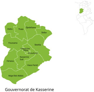
Kasserine Governorate, sometimes spelt Casrein, is one of the twenty-four governorates (provinces) of Tunisia. It is in west-central Tunisia on the frontier with Algeria, wholly north of the true centre line but the area is south or west of the bulk of the population of the country, based on Tunisia's greater northern rainfall. It covers an area of 8,260 km2 and has a population of 468,925 (2023).The capital is Kasserine which is at the foot of Jebel ech Chambi, Tunisia's highest mountain, in turn part of the Dorsal Atlas mountains. The mountain and its associated escarpment form its own national park in the province.

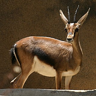
Cuvier's gazelle is a species of gazelle native to Algeria, Morocco, Western Sahara, and Tunisia. It is also known as the edmi. It is one of the darkest gazelle species, possibly an adaptation to its partial woodland habitat. It is sometimes placed into the genus Trachelocele together with the goitered gazelles and the rhim gazelles.

Jebel ech Chambi is a mountain peak in Tunisia. At an elevation of 1,544 m (5,066 ft), it is the highest mountain in the country. It stands above the city of Kasserine in western central Tunisia. The summit is covered by a pine forest and is part of Chambi National Park.

The Mediterranean woodlands and forests is an ecoregion in the coastal plains, hills, and mountains bordering the Mediterranean Sea and Atlantic Ocean in North Africa. It has a Mediterranean climate, and is in the Mediterranean forests, woodlands, and scrub biome.

The following outline is provided as an overview of and topical guide to Tunisia:

Wadi Wurayah is a 12,700-hectare (31,000-acre) wadi between the towns of Masafi, Khor Fakkan, and Bidiyah in the United Arab Emirates. It has been designated as Ramsar Wetland of International Importance. The lush canyon in the area was named after the tall marsh plant known as ‘warrah’, that flourishes in its wetlands, while the word ‘wadi’ is the Arabic term for valley.

Ras Jebel, also known as Ras el-Djebel, is a town and commune in the Bizerte Governorate of Tunisia. The name of the city refers to the summit or end of the mountain, thus evoking the end of the Atlas Mountains.

Soliman, Tunisia is a town and commune in the Nabeul Governorate, in the north-eastern part of Tunisia. As of 2017, it had a population of 57,060.
Mezzouna is a town and commune in the Sidi Bou Zid Governorate, Tunisia. As of 2004, it had a population of 6,101.

Kesra is a town and commune in the Siliana Governorate, Tunisia. As of 2004 it had a population of 2,490. In 2014 this was 2,600. Kesra is in Siliana Governorate near Maktar at 35.8N and 9.36e. The town is at altitude of 966m and is near the Jebel Serj national park. During the Roman Empire Kesra was a civitas of the Roman Province of Byzacena called Cusira.

Jebel Boukornine, also spelled Djebel Bou Kornine or Mount Bou Kornine, is a 576 metres (1,890 ft) mountain in northern Tunisia overlooking the Gulf of Tunis and the city of Hammam Lif. It consists of folded and faulted outcrops of Jurassic limestone.

The Chaambi Operations, or Battle of Chaambi were part of the insurgency in the Maghreb. In December 2012, the Tunisian Army launched an offensive against the Salafist jihadists in Jebel ech Chambi near Kasserine. The conflict ended with the victory of the Tunisian Army in 2019.

North West Tunisia is one of the six geographic and economic regions of Tunisia, consisting of four governorates: Béja, Kef, Siliana and Jendouba. The region had a population of 1,170,752 representing 12.2% of the total population of Tunisia. This makes it the 5th-most populous region in the country, with only South West Tunisia being smaller.

Dubai Investments Park (DIP), including Dubai Investment Park 1 and Dubai Investment Park 2, is a business park area in Dubai, United Arab Emirates, including commercial, and industrial, and residential development. The Green Community Village and Green Community East in DIP 1 are to the north and Dunes Village in DIP 2 is to the northeast. DIP was established in 1995.

The Djebel Serj is a limestone mountain located in the center of Tunisia, within the Tunisian ridge. It rises to 1,357 meters above sea level. The mountain is located at 35° 56′ 12″n, 9° 32′ 59″e

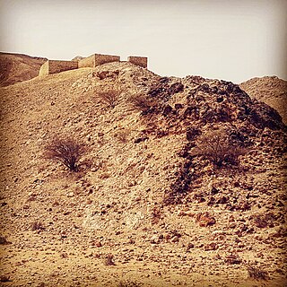
Jebel Buhais or Jebel Al-Buhais is a geological feature, an extensive rocky outcrop, as well as an archaeological site located near Madam in the central region of the Emirate of Sharjah, the UAE, about 48 kilometres southeast of the city of Sharjah. The area contains an extensive necropolis, consisting of burial sites spanning the Stone, Bronze, Iron and Hellenistic ages of human settlement in the UAE. Burials at Jebel Buhais date back to the 5th Millennium BCE. The site is located to the side of a limestone outcrop rising to some 340 metres above sea level and which runs almost contiguously from the town of Madam north to the town of Mleiha, itself an important archaeological site.
Central West Tunisia or in is the region located at the Central West of Tunisia which assembles Three of the following states: Sidi Bouzid, Kairouan and Kasserine.