

Ghana has a large system of 21 protected areas which include 7 national parks, 6 Resource Reserves, 2 Wildlife Sanctuaries, 1 Strict Nature Reserve and 5 coastal wetlands. [1]
Ghana has a large system of 21 protected areas which include 7 national parks, 6 Resource Reserves, 2 Wildlife Sanctuaries, 1 Strict Nature Reserve and 5 coastal wetlands. [1]

Ghana is a West African country in Africa, along the Gulf of Guinea.

The New England National Park is a protected national park located on the Northern Tablelands in the New England region of New South Wales, Australia. The 67,303-hectare (166,310-acre) park was created in May 1935 and is situated approximately 560 kilometres (350 mi) north of Sydney, and 10 kilometres (6.2 mi) south of Waterfall Way, just 85 kilometres (53 mi) east of Armidale and 65 kilometres (40 mi) west of Coffs Harbour. The closest village to New England National Park is Ebor, located 20 kilometres (12 mi) away.

Tamborine National Park is a protected area split between the City of Gold Coast and the Scenic Rim Region in South East Queensland, Australia, 67.5 km (41.9 mi) by road south of Brisbane.

The Malabar Coast moist forests are a tropical moist broadleaf forest ecoregion of southwestern India.

The Eastern Guinean forests are a tropical moist broadleaf forest ecoregion of West Africa.

Korup National Park is in the Southwest Province of Cameroon and extends over 1,260 km2 of mostly undisturbed primary forest. It is reputedly one of Africa's oldest and richest tropical forests in terms of floral and faunal diversity. It is the most accessible rainforest national park in Cameroon with basic lodging infrastructure and a large network of trails open to visitors. The park is a popular birdwatching destination and famous for primate viewing. Researchers from various disciplines have been conducting biological studies in Korup for over three decades, generating a wealth of information on rainforest ecosystems.

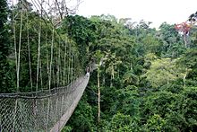
Kakum National Park, located in the coastal environs of the Central Region of Ghana, covers an area of 375 square kilometres (145 sq mi). Established in 1931 as a reserve, it was gazetted as a national park only in 1992 after an initial survey of avifauna was conducted. The area is covered with tropical forest. The uniqueness of this park lies in the fact that it was established at the initiative of the local people and not by the State Department of wildlife who are responsible for wildlife preservation in Ghana. It is one of only 3 locations in Africa with a canopy walkway, which is 350 metres (1,150 ft) long and connects seven tree tops which provides access to the forest.

The Madagascar dry deciduous forests represent a tropical dry forest ecoregion situated in the western and northern part of Madagascar. The area has high numbers of endemic plant and animal species but has suffered large-scale clearance for agriculture. They are among the world's richest and most distinctive dry forests and included in the Global 200 ecoregions by the World Wide Fund. The area is also home to distinctive limestone karst formations known as tsingy, including the World Heritage Site of Bemaraha.

The Ankasa Conservation Area is located in southwestern Ghana, approximately 365 kilometers west of Accra, near the border with Côte d'Ivoire. It encompasses the Nini Suhien National Park to the north and the Ankasa Forest Reserve to the south.

The word Maharashtra, the land of the mainly Marathi-speaking people, appears to be derived from Maharashtri, an old form of Prakrit. Some believe that the word indicates that it was the land of the Mahars and the Rattas, while others consider it to be a corruption of the term 'Maha Kantara', a synonym for 'Dandakaranya'. Maharashtra is the third largest state in India after Rajasthan and Madhya Pradesh. It covers an area of 307,713 km2 and is bordered by the states of Madhya Pradesh to the north, Chhattisgarh to the east, Telangana to the southeast, Karnataka to the south and Goa to the southwest. The state of Gujarat lies to the northwest, with the Union territory of Dadra and Nagar Haveli sandwiched between the borders. Maharashtra has coastline of 720 km.The Arabian Sea makes up Maharashtra's west coast. Maharashtra consists of two major relief divisions. The plateau is a part of the Deccan tableland and the Konkan coastal strip abutting on the Arabian Sea.

Warren, also known as Karri Forest Region and the Jarrah-Karri forest and shrublands ecoregion, is a biogeographic region in southern Western Australia. Located in the southwest corner of Western Australia between Cape Naturaliste and Albany, it is bordered to the north and east by the Jarrah Forest region. Its defining characteristic is an extensive tall forest of Eucalyptus diversicolor (karri). This occurs on dissected, hilly ground, with a moderately wet climate. Karri is a valuable timber and much of the karri forest has been logged over, but less than a third has been cleared for agriculture. Recognised as a region under the Interim Biogeographic Regionalisation for Australia (IBRA), and as a terrestrial ecoregion by the World Wide Fund for Nature, it was first defined by Ludwig Diels in 1906.

Valdivian Coastal Reserve is a natural reserve located in the Cordillera Pelada, in Los Ríos Region of Chile, near Corral.

The wildlife of Cameroon is composed of its flora and fauna. Bordering Nigeria, it is considered one of the wettest parts of Africa and records Africa's second highest concentration of biodiversity. To preserve its wildlife, Cameroon has more than 20 protected reserves comprising national parks, zoos, forest reserves and sanctuaries. The protected areas were first created in the northern region under the colonial administration in 1932; the first two reserves established were Mozogo Gokoro Reserve and the Bénoué Reserve, which was followed by the Waza Reserve on 24 March 1934. The coverage of reserves was initially about 4 percent of the country's area, rising to 12 percent; the administration proposes to cover 30 percent of the land area.

Kutai National Park is a lowland national park located on the east coast of Borneo Island, in the East Kalimantan province of Indonesia, ranging approximately 10 to 50 km north of the equator.

The Kimberley tropical savanna is a tropical and subtropical grasslands, savannas, and shrublands ecoregion in northwestern Australia, covering portions of Western Australia and the Northern Territory south of the Timor Sea.
The Boin Tano Forest Reserve is a nature reserve located in the Western Region of Ghana. It was established in 1968. This site, which is 129 km2 (50 sq mi), is rich in both floral and faunal species.
Bomfobiri Wildlife Sanctuary is a bird sanctuary, located about 80 km northeast of Kumasi within a geographical coordinate of 06°54.595'N and 001°17.340'W. The 53 km2 Bomfobiri Wildlife Sanctuary was created in 1975 with a four distinct vegetative types such as Riverine Forest, Rainforest, Woodland Savannah and Grassland Savannah. Animals present on the reserve include several species of birds, crocodiles, baboons, Mona monkeys, buffalos, red river hogs, Maxwell's duiker, red flank duiker, Bushbuck and monitor lizards. The reserve has many forms of attraction point including the Lion Stone, Stone Bridge, Bomfobiri waterfall, Wala waterfall, and caves. Activities that can be engaged in includes hiking, mountain climbing, game viewing, bird watching, camping and swimming. The reserve takes the crocodile as its symbol.

The Northwestern Congolian lowland forests is a tropical moist broadleaf forest ecoregion that spans Cameroon, Gabon, the Republic of Congo, the Central African Republic and a minuscule part of the Democratic Republic of the Congo. It forms part of the larger Congolian rainforests region in Central Africa. The region is noteworthy for very high levels of species richness and endemism. It is home to a core population of the critically endangered Western lowland gorilla. There are also large populations of forest elephants.

The Western Congolian forest–savanna mosaic is an ecoregion of Angola, Democratic Republic of the Congo, Republic of the Congo, and Gabon.

Limeburners Creek National Park is a protected national park on the Mid North Coast of New South Wales, Australia. The 91.2 km national park is located 5 km (3.1 mi) to the north of Port Macquarie and exists across both the Kempsey Shire and Port Macquarie-Hastings Council local government areas, but is chiefly managed by National Parks and Wildlife Service. The area was originally erected as a nature reserve but this reservation was revoked when it became formally recognised as a national park in 2010 under the National Parks and Wildlife Act (1974). Many threatened ecological habitats and species of fauna and flora are found within this park, alongside several heritage sites of cultural significance, particularly to the local Birpai and Dunghutti people upon whose land the park exists. The protected status of this national park is largely owing to the ecological and cultural value of the area, in addition to the value of the ecosystems to further scientific research.