Techiman

Last updated

Techiman
Town
Ghana adm location map.svg
Red pog.svg
Techiman
Location of Techiman, Capital of Bono East Region, Ghana
Coordinates: 7°35′00″N1°56′10″W / 7.58333°N 1.93611°W / 7.58333; -1.93611
CountryFlag of Ghana.svg  Ghana
Region Bono East Region
District Techiman Municipal
Population
 (2013)
  Total104,212 [1]
Time zone GMT
  Summer (DST) GMT

Techiman is a city and is the capital of Techiman Municipal and Bono East Region of Ghana. Techiman is a leading market town in South Ghana. Techiman is one of the two major cities and settlements of Bono East region. Techiman is home to West Africa's largest traditional market. Techiman has a settlement population of 104,212 people in 2013. [1] Techiman is located at a historical crossroads of trade routes and the Tano River, and serves as capital of the Techiman Municipal District.

Contents

History

According to oral tradition, the Akans who constitute the largest ethnic group in Ghana, moved from ancient Bono State; a historical location known as Bono Manso, a suburb in Techiman Municipality. The Fantes (an Akan people ), according to their oral tradition, migrated from Techiman to found the coastal Mankessim Kingdom that covers present Central region and Western regions in 1252. Others from the Akan people would later follow and formed their own states and city states, such as the now extinct Adanse state, the Akyem and Akwamu states, among others. [2] After Bono Manso, capital of the Bono state, was taken by the Ashanti Empire in 1723, then the Bono-Techiman state was founded in 1740 under Ashanti sovereignty. [2] However, all the Akans according to oral tradition settled and migrated from Bono and were part of the Bono State until when the Bono State was conquered in war by the Ashantis.

TechimanWest.jpg
The western skyline of Techiman

Techiman is the heart of the Bonokyempem clan, [3] a group of Traditional Bono Ahafo Chiefs who eventually joined forces and campaigned for the formation of the Brong Ahafo Region from the Ashanti Region on April 4, 1959, in accordance with the Ashanti Region Act 18 of 1959. Nana Kwaakye Ameyaw III, former paramount chief of Bono

Traditional Area, was the driving force behind the founding of the "Bonokyempem" clan.

Climate

Climate data for Techiman(1991–2021)
MonthJanFebMarAprMayJunJulAugSepOctNovDecYear
Mean daily maximum °C (°F)33.8
(92.8)
34.3
(93.8)
33.5
(92.3)
32.3
(90.2)
31.1
(88.0)
29.2
(84.5)
27.9
(82.3)
27.8
(82.0)
28.4
(83.2)
29.4
(85.0)
30.8
(87.4)
32.6
(90.7)
30.9
(87.7)
Mean daily minimum °C (°F)21.3
(70.3)
22.8
(73.1)
23.6
(74.4)
23.6
(74.4)
23.1
(73.6)
22.2
(71.9)
21.6
(70.8)
21.4
(70.6)
21.6
(70.8)
22.4
(72.3)
22.0
(71.6)
21.3
(70.4)
22.2
(72.0)
Average precipitation mm (inches)23
(0.9)
51
(2.0)
112
(4.4)
137
(5.4)
138
(5.4)
133
(5.2)
119
(4.7)
128
(5.0)
192
(7.6)
163
(6.4)
76
(3.0)
26
(1.0)
1,298
(51)
Source: Climate-data.org [4]

Demographics

1960197019841989200020072013Recent[ when? ]
8,755 [5] 12,068 [6] 25,264 [5] 36,785 [7] 56,187
(projection) [5]
79,547
(projection) [6]
104,212
(projection) [1]
104,212 [1]

The population has grown rapidly in recent decades, doubling between the 1970 and 1984 censuses, and again doubling by the next census in 2000. The estimate of 79,547 in 2007, is nine times the population that the town had in 1960.

Institution

Education

Vegetation and Agriculture

The Techiman Municipality contains three major vegetation zones: the Guinea-Savanna woodland in the north-west, the semi-deciduous zone [10] in the south, and the Transitional zone [10] extending from the south-east and west to the north.

The principal land uses include crop production and livestock production. Aquaculture is on the verge of development and a tiny portion is undergoing replanted to join Asubima Forest Reserve.

Market

Techiman is undeniably one of Ghana's busiest cities, and it is widely regarded as one of the country's top commercial centres. Techiman is home to West Africa's largest traditional market. It is frequented by merchants from Togo, Benin, Côte d'Ivoire, Burkina Faso, and Mali.

The Techiman Municipality is strategically located between the savanna and forest zones of Ghana, making it an ideal trading hub.

Techiman is commonly referred to as the "Food Basket of Ghana" due to the fact that its market operations take place from Tuesday through Friday every week of the year, attracting traders from around West Africa. [11]

Due to the city's socioeconomic structure, Techiman's population is very cosmopolitan, consisting of individuals from many racial, economic, and social-political backgrounds.

Culture

Mount Olives, opened in 2012, is one of two general hospitals in Techiman. OpenStreetMap
7deg35'46''N 1deg55'22''W / 7.5962degN 1.9227degW / 7.5962; -1.9227 MountOlives.Techiman.GH-BA.jpg
Mount Olives, opened in 2012, is one of two general hospitals in Techiman. OpenStreetMap 7°35′46″N1°55′22″W / 7.5962°N 1.9227°W / 7.5962; -1.9227

Techiman has started the construction of a modern culture centre. The purpose of the centre is the preservation of the traditions of the Bono nation. [12] Techiman celebrates the annual Apoo in April/May – a kind of Mardi Gras. Before 2009, the celebration of Apoo had been suspended for several years due to the decease of the Bonoman king. The climax of the Apoo is the durbar of the king (Omanhene) through Techiman. [12] In August, an annual yam ceremony takes place and it marks the end of the yam production in the Brong-Ahafo Region towns of Techiman and Wenchi. [12] Ghana government support Techiman Land with money( gift ). The gift is for the development of their Land and the protection of their culture. [13]

Transport

Techiman is connected by road to Sunyani and its domestic airport, the Sunyani Airport. [2] [12] Techiman is not yet serviced by a railway station on the Ghana Railway Corporation, and it has been proposed that a line be extended to Techiman. The Tano River is a navigable river. [12]

There are Public Transports from Techiman to major cities such as Accra  ; Kumasi; Mim, Ahafo  ; Sunyani; Takoradi; Tema; Ho; Wa; Bolgatanga; Elubo; Aflao

A study of traffic in Techiman in March 2007 found a breakdown of 34% for taxis, 31% for pedestrians, 10% for buses and vans, 7% for bicycles, 6% for motorbikes, 5% for cars and 7% for "other" modes of transportation. Of bicyclists, a focus of the study, 49% travelled for work, 18% for school, 14% for recreation and 6% for touring. [14]

Sister city

Techiman, in partnership with nearby Sunyani, currently has a sister city relationship with: [15]

CountryCityCounty / District / Region / StateDate
Flag of the United States.svg  United States Tuscaloosa Flag of Alabama.svg  Alabama

On 11 October 2012, Techiman and Sunyani municipalities signed a Memorandum of Understanding (MoU) to seal their sister-city relationship with Tuscaloosa Sister Cities International of Alabama State in the United States. [16]

Sports

Related Research Articles

<span class="mw-page-title-main">Regions of Ghana</span> 16 principal administrative areas of the republic in West Africa

The regions of Ghana are the first level of subnational government administration within the Republic of Ghana. As of 2020, there are 16 regions, which are further divided for administrative purposes into 260 local metropolitan, municipal and district assemblies.

<span class="mw-page-title-main">Brong-Ahafo region</span> Region in Ghana

The Brong-Ahafo region was a region in central Ghana. Brong-Ahafo was bordered to the north by the Black Volta river and to the east by the Lake Volta, and to the south by the Ashanti, Eastern and Western regions. The capital of Brong-Ahafo is Sunyani. Brong-Ahafo was created on 14 April 1959 from the then Western Ashanti and named after the main ethnic groups, the Brong and Ahafo. In 2019, as a result of the 2018 Ghanaian new regions referendum, the region was divided into three, namely Bono, Bono East and Ahafo regions, and ceased to exist.

The Akan people are a Kwa group living primarily in present-day Ghana and in parts of Ivory Coast and Togo in West Africa. The Akan speak dialects within the Central Tano branch of the Potou–Tano subfamily of the Niger–Congo family. Subgroups of the Akan people include: the Agona, Akuapem, Akwamu, Akyem, Anyi, Ashanti, Baoulé, Bono, Chakosi, Fante, Kwahu, Sefwi, Wassa, Ahanta, and Nzema, among others. The Akan subgroups all have cultural attributes in common; most notably the tracing of matrilineal descent in the inheritance of property, and for succession to high political office.

Bono State was a trading state created by the Bono people, located in what is now southern Ghana. Bonoman was a medieval Akan state in what is now Bono, Bono East and Ahafo region respectively named after the and Eastern Ivory Coast. It is generally accepted as the origin of the subgroups of the Akan people who migrated out of the state at various times to create new Akan states in search of gold. The gold trade, which started to boom in Bonoman as early in the 14th century, was the genesis of Akan War, power and wealth in the region, beginning in the Middle Ages.
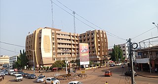
<span class="mw-page-title-main">Sunyani</span> City in Bono, Ghana

Sunyani is the capital town of the Bono Region and the Sunyani Municipal of Ghana. Sunyani had a population of 1,208,649 at the 2021 population and housing census. The city consists mainly of the Bonos other tribes.

<span class="mw-page-title-main">Bono people</span> Ethnic group in Ghana and Ivory Coast

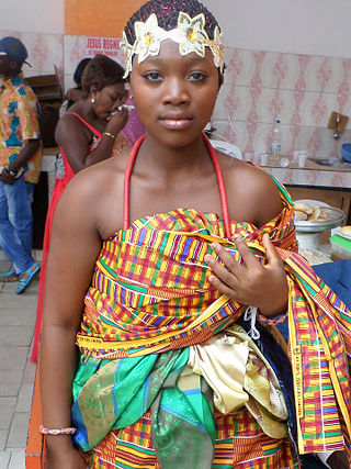
The Bono, also called the Brong and the Abron, are an Akan people of West Africa. Bonos are normally tagged Akan piesie or Akandifo of which Akan is a derivative name. Bono is the genesis and cradle of Akans. Bono is one of the largest ethnic group of Akan and are matrilineal people. Bono people speak the Bono Twi of Akan language. Twi language, thus the dialect of Bono is a derivative of a Bono King Nana Twi. In the late fifteenth century, the Bono people founded the Gyaaman kingdom as extension of Bono state in what is now Ghana and Côte d'Ivoire.

Bono, also known as Abron, Brong, and Bono Twi, is a Central Tano language common to the Bono people and a major dialect of the Akan dialect continuum, and thus mutually intelligible with the principal Akan dialects of Asante and Akuapem, collectively known as Twi. It is spoken by 1.2 million in Ghana, primarily in the Central Ghanaian region of Brong-Ahafo, and by over 300,000 in eastern Ivory Coast.

Nkoranza is a town located in the mid-north of Ghana. It is the district capital of the Nkoranza District in the Bono East Region.

The Apoo Festival is a festival celebrated annually in western Ghana, lasting a week in March and April. The festival is meant to ritually purify the people of social evils, as well as uniting people and families, and includes a variety of other traditional cultural activities. The word 'apoo' comes from the root word 'po', meaning 'to reject.'

<span class="mw-page-title-main">Asante people</span> Nation and ethnic group in Ghana

The Asante, also known as Ashanti, are part of the Akan ethnic group and are native to the Ashanti Region of modern-day Ghana. Asantes are the last group to emerge out of the various Akan civilisations. Twi is spoken by over nine million Asante people as a first or second language.

<span class="mw-page-title-main">Wenchi</span> Town in Bono, Ghana

Wenchi is a town and is the capital of Wenchi Municipal of the Bono Region in middle-belt of Ghana. Wenchi is located at 7.73333 [latitude in decimal degrees], -2.1 [longitude in decimal degrees] at an average elevation/altitude of 304 meters. Wenchi is approximately 30 km north of Techiman and about 50 km east of the Ivory Coast border. Wenchi has a population of 39,187 people in 2013.

Brong Ahafo United is a Ghanaian football Club, based in Sunyani, currently competing in the Ghana Premier League. It was established in 1960 to bring the people of Bono or Brong and Ahafo together through football. The club is also known as Apostles of power soccer. Their long time regional rival is Bofoakwa Tano, a club based in Sunyani as well. Other known clubs in the region are Aduana Stars(two time GPL champions), Berekum Chelsea, Young Apostles(BA United seed), DC United, Nsoatreman, Wamnafo might Royals, and few other clubs not mentioned.

Duayaw Nkwanta is a town and the capital of Tano North Municipal District, a municipal in the Ahafo Region of Ghana. It is located close to Sunyani, the capital of Bono Region. The infrastructure of Duayaw Nkwanta is well structured. Duayaw Nkwanta has a settlement population of 27,476. This town boast of good schools such as: Boakye Tromo Senior High Technical School, Serwaa Kesse Girls Senior High School, Presbyterian Midwifery Training College among others.

Fiapre is a town in Sunyani West Municipal in the Bono Region of Ghana. Fiapre is very close to the regional capital town of the Bono Region, Sunyani.

<span class="mw-page-title-main">Banda Ahenkro</span> Town and District Capital in Bono Region, Ghana

Banda Ahenkro is a town located in the west-northern of Bono region, Ghana, near the border of Ivory Coast. Its geography provided a home for numerous groups seeking shelter from across West Africa during the slave trade era. The original name of the settlement was Serminakuu meaning groups of 'grasses'. This name was changed to Banda, which is a corruption of 'Woanda' meaning 'they did not sleep'. Ancestors of Banda Ahenkro were allies of the Asante kingdom during wars and they provided a military force that virtually refused to sleep during at-war times. This is because they were predominantly Muslims and were found praying throughout the night. Later, 'woanda' was also corrupted by the Bono neighbours to become Banda. The settlement evolved to become the chief town or 'Ahenkro' within a collection of Nafana communities.

Atebubu College of Education is a teacher education college in Atebubu. The college is located in Ashanti / Brong Ahafo zone. It is one of the 46 Public Colleges of Education in Ghana. The college participated in the DFID-funded T-TEL programme. It was founded in October 1965. it was the premier second cycle institution and also the only teacher training college in the eastern corridor of the region.

<span class="mw-page-title-main">Bono Region</span> Region of Ghana

The Bono region is one of the 16 administrative regions of Ghana. It is as a result of the remainder of Brong-Ahafo region when Bono East region and Ahafo region were created. Sunyani, also known as the green city of Ghana, is the regional capital. Sunyani can pride itself as the cleanest capital city and a major conference destination.

<span class="mw-page-title-main">Bono East Region</span> Region of Ghana

The Bono East region of Ghana is a new region carved out of the Brong Ahafo region. The capital of the new region is Techiman. This creation of this new region was in fulfillment of a promise made by the New Patriotic Party prior to the 2016 Ghana general election. Upon winning the elections, the President, Nana Akuffo Addo created the Ministry of Regional Reorganization to oversee policy formulation and implementation. In all six new regions are to be created from the existing ten regions of Ghana. The other regions are Bono, Western North, Ahafo, Savannah, North East, and Oti regions.

Tanoboase Sacred Grove and Shrine is near the village of Tanoboase in the Techiman, Brong Ahafo region of Ghana. It is believed to be the cradle and the traditional home of the Bono people. It is said by the Tanoboase people that powerful Ashanti Gods reside in the sacred grove. Historically the site is where Ashanti Wars were fought. The grove was a hideout during the slave trade and inter-tribal wars. The grove is also a place for religious activities.

References

  1. 1 2 3 4 "World Gazetteer online". World-gazetteer.com. Archived from the original on 30 September 2007.
  2. 1 2 3 "Warren African Art – Techiman". online. 2001. Archived from the original on 16 June 2008. Retrieved 13 June 2008.
  3. Brempong, Owusu (1998). Oral tradition in Ghana : the history of Bonokyempim and Techiman politics. Institute of African Studies, University of Ghana, [Ghana]. p. 1.
  4. "Techiman Climate". Climate-data. Retrieved 5 October 2023.
  5. 1 2 3 "Techiman Municipal: Demographic Characteristics tables" (PDF). A Public – Private Partnership Programme between Min. of Local Govt., Rural Dev. & Environment & Maks Publications & Media Services. 2006. Retrieved 13 June 2008.
  6. 1 2 "Techiman Municipal: Demographic Characteristics". A Public – Private Partnership Programme between Min. of Local Govt., Rural Dev. & Environment & Maks Publications & Media Services. 2006. Archived from the original on 22 November 2007. Retrieved 13 June 2008.
  7. Sweetman, Caroline, ed. (1995). "Coping with transition through organisation: Techiman Market, Brong-Ahafo, Ghana". Societies in Transition. Oxfam. pp. 43–48. ISBN   0-85598-339-6.
  8. "Implement Asamang-Tamfoe community mining plan — Youth group". Joynewsplus.com. 13 January 2022. Retrieved 27 May 2022.
  9. 1 2 GNA (20 January 2021). "Support children to obey COVID-19 protocols, says Amoakohene". Ghana News Agency. Retrieved 16 November 2022.
  10. 1 2 i. Abbam,Tawia ii. Amoako Johnson, Fiifi iii. Dash Jyoti iv. Padmadas, Sabu (24 March 2018). "Spatiotemporal Variations in Rainfall and Temperature in Ghana Over the Twentieth Century". Earth and Space Science. 5. doi: 10.1002/2017EA000327 . S2CID   133734889 via ResearchGate.{{cite journal}}: CS1 maint: multiple names: authors list (link)
  11. K. Antwi, George (26 April 2017). "Putting Techiman On The Map Of Ghana". Modern Ghana. Retrieved 19 September 2022.
  12. 1 2 3 4 5 Touring Brong Ahafo Archived 17 May 2012 at the Wayback Machine
  13. "Techiman to establish a cultural village : modern Ghana". www.modernghana.com.
  14. "Cycling in Techiman" (PDF). The CCE Newsletter. 4 (1–2). Centre for Cycling Expertise: 1. January–March 2008. Retrieved 13 June 2008.
  15. "Tuscaloosa Sister Cities International". Tuscaloosa Sister Cities Commission. Retrieved 26 August 2011.
  16. "Sunyani & Techiman Twin Towns". Ghana Place Names.

Literature