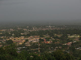
Ho is the capital city of the Ho Municipal District and the Volta Region of Ghana. The city lies between Mount Adaklu and Mount Galenukui or Togo Atakora Range, and is home to the Volta Regional Museum, a cathedral, and a prison. The city is the capital of unrecognised Western Togoland. It was formerly the administrative capital of British Togoland now part of the Volta Region. The population of Ho Municipality according to the 2010 Population and Housing Census is 177,281 representing 8.4 percent of the region's total population. Females constitute 52.7 percent and males represent 47.3 percent. The population in Ho grew up to 180,420 National Population Census. About 62 percent of the population resides in urban localities. The Municipality shares boundaries with Adaklu and Agotime-Ziope Districts to the South, Ho West District to the North and West and the Republic of Togo to the East. Its total land area is 2,361 square kilometers thus representing 11.5 percent of the region's total land area.

The Mfantsefo or Fante are an Akan people. The Fante people are mainly located in the Central and Western coastal regions of Ghana. Over the last half century, due to fishing expeditions, Fante communities have been established as far as Gambia, Liberia and even Angola. Major Fante cities in modern Ghana include Kasoa, Winneba, Agona Swedru, Tarkwa, Oguaa, Edina (Elmina), Mankessim, Sekondi and Takoradi.
Techiman is a city and is the capital of Techiman Municipal and Bono East Region of Ghana. Techiman is a leading market town in South Ghana. Techiman is one of the two major cities and settlements of Bono East region. Techiman is home to West Africa's largest traditional market. Techiman has a settlement population of 104,212 people in 2013. Techiman is located at a historical crossroads of trade routes and the Tano River, and serves as capital of the Techiman Municipal District.
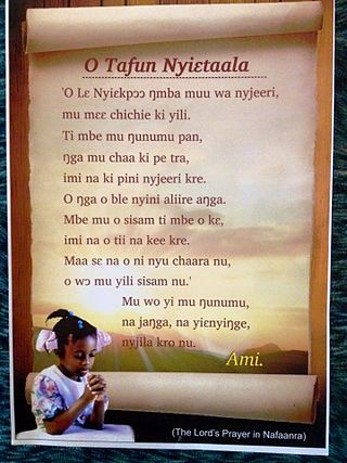
Sampa is a town in the Bono Region of Ghana, on the border with Côte d'Ivoire. It is the capital of Jaman North District, and was formerly the site of a Slave market. It was also the capital of the Akan State of Gyaaman in the late 15th century. It is the biggest border town in Ghana with a population of over 36,000. It is the principal town of the Nafana ethnic group. They speak the Nafaanra language and equally speak Twi as a second language because Sampa is a cosmopolitan society. Nafaanra is also spoken in Banda District, parts of Tain District and Bondoukou District of Cote d'Ivoire. It is the leading producer of Cashew in Ghana.
Sunyani is the capital town of the Bono Region and the Sunyani Municipal of Ghana. Sunyani had a population of 1,208,649 at the 2021 population and housing census. The city consists mainly of the Bonos other tribes.
Articles related to Ghana include:
Akropong is a town in South Ghana and is the capital of the Akuapim North District, a district in the Eastern Region of South Ghana. This town is known for producing snails and palm oil. Akropong has a 2013 settlement population of 13,785 people.

Wenchi is a town and is the capital of Wenchi Municipal of the Bono Region in middle-belt of Ghana. Wenchi is located at 7.73333 [latitude in decimal degrees], -2.1 [longitude in decimal degrees] at an average elevation/altitude of 304 meters. Wenchi is approximately 30 km north of Techiman and about 50 km east of the Ivory Coast border. Wenchi has a population of 39,187 people in 2013.
The Sefwi are an Akan people.
Shama or Shema is a town with a fishing village, and is the capital of Shama district, a district in the Western Region of Ghana. The town lies about 20 km east of Sekondi-Takoradi, on the mouth of the Pra River. The town is home to Fort San Sebastian, in whose graveyard philosopher Anton Wilhelm Amo, the first African known to have attended a European university, is interred.
Duayaw Nkwanta is a town and the capital of Tano North Municipal District, a municipal in the Ahafo Region of Ghana. It is located close to Sunyani, the capital of Bono Region. The infrastructure of Duayaw Nkwanta is well structured. Duayaw Nkwanta has a settlement population of 27,476. This town boast of good schools such as: Boakye Tromo Senior High Technical School, Serwaa Kesse Girls Senior High School, Presbyterian Midwifery Training College among others.

Kintampo is a town and tourist destination in the Bono East Region of Ghana. It became the capital of Kintampo North Municipal in 2004. Kintampo has a population of 111 000. It also served as the capital of the former Kintampo District. Kintampo also has a Senior High School which is located at Kyeremankoma. There is a college of health called Kintampo College of Health and Well-being (CoHK) in the town. Most of the population in Kintampo are farmers, with production focused on yams, maize, legumes, tubers and other vegetables. Both the Bono and the Mo tribe are indigenous to the region. Kintampo is a cosmopolitan town, apart from the indigenous tribe, other tribes like the Wangaras, Gonjas, Konkombas and others are also inhabitants of the town. The annual Benkadi Kurubi festival of the Wangara community in Ghana always takes place at Kintampo.
Banda Ahenkro is a town located in the west-northern of Bono region, Ghana, near the border of Ivory Coast. Its geography provided a home for numerous groups seeking shelter from across West Africa during the slave trade era. The original name of the settlement was Serminakuu meaning groups of 'grasses'. This name was changed to Banda, which is a corruption of 'Woanda' meaning 'they did not sleep'. Ancestors of Banda Ahenkro were allies of the Asante kingdom during wars and they provided a military force that virtually refused to sleep during at-war times. This is because they were predominantly Muslims and were found praying throughout the night. Later, 'woanda' was also corrupted by the Bono neighbours to become Banda. The settlement evolved to become the chief town or 'Ahenkro' within a collection of Nafana communities.

The Konkomba people are a Gur ethnic group residing mainly in the Northern, Brong Ahafo, Volta, Eastern and Greater Accra Regions of Ghana. Saboba, Chereponi and Nanumba Districts, Gushiegu and Karaga districts, East Mamprusi, Yunyoo-Nasuan, Zabzugu and Tatale-Sanguli districts in the Northern Region and the Nkwanta North and South Districts in the Volta Region are a few examples of administrative districts where Bikpakpaam are seen in huge populations. Other key districts where Bikpakpaam are in Ghana are Atebubu, Kintampo, Techiman and Yeji in the Brong Ahafo Region. According to the Act 280 of the Anatomy act of Ghana, the Konkomba people are the second largest ethnic group in the Northern Region of Ghana.

The Bono region is one of the 16 administrative regions of Ghana. It is as a result of the remainder of Brong-Ahafo region when Bono East region and Ahafo region were created. Sunyani, also known as the green city of Ghana, is the regional capital. Sunyani can pride itself as the cleanest capital city and a major conference destination.
Nkyifie (Yam) Festival is an annual festival celebrated by the chiefs and people of Prang Traditional Area in the Pru West District in the Bono East Region, formerly the Brong Ahafo region of Ghana. It is usually celebrated in the month of September. Others also claim it is celebrated in October or December. Others also claim it is celebrated in November.
Foyawoo Festival is an annual festival celebrated by the chiefs and people of Atebubu, Kwafie and Amanten Traditional Areas in the Bono East region, formally Brong Ahafo Region of Ghana. It is usually celebrated in the month of October. Others also claim it is celebrated in the month of September.
Munufie Festival is an annual festival celebrated by the chiefs and people of Mpuasuman-Japekrom Traditional Area in the Jaman South District in the Bono region, formerly Brong Ahafo Region of Ghana. It is usually celebrated in the month of October. The people of Mpuasu-Japekrom Traditional Area also celebrate theirs in September. The people and chiefs of Abi Traditional Area also celebrate theirs in September.
Sefwi Debiso is a town in the Bia West District in the Western North Region of Ghana. It is a central town located between three major towns: Essam, Sefwi Adabokrom and Adwuofua. Because of rapid expansion, Debiso has conurbated with the nearby Community Essam. Presently, Sefwi Debiso & Essam serve as co-capitals of the Bia West District. There are direct distant routes from Debiso to major towns such as Kumasi, Berekum, Mim Ahafo, Sefwi-Wiawso and republic of Ivory Coast. Debiso is known for producing cocoa and timber. Debiso is also noted for the Bia National Park.
Adabokrom is a town in Western North Region of Ghana. It is the capital of Bia East. Adabokrom was named the District capital after Bia East District split from Bia District in 2012. Adabokrom is about 250 km west of Kumasi. The town is noted for cocoa production.


