
Ghana is a West African country in Africa, along the Gulf of Guinea.

Transport in Ghana is accomplished by road, rail, air and water. Ghana's transportation and communications networks are centered in the southern regions, especially the areas in which gold, cocoa, and timber are produced. The northern and central areas are connected through a major road system.

The Volta River is the main river system in the West African country of Ghana. It flows south into Ghana from the Bobo-Dioulasso highlands of Burkina Faso. The main parts of the river are the Black Volta, the White Volta, and the Red Volta. In the northwest, the Black Volta forms the international borders between the Ivory Coast, Ghana, and Burkina Faso. The Volta flows southward along the Akwapim-Togoland highlands, and empties into the Atlantic Ocean at the Gulf of Guinea at Ada Foah. One of its smaller tributaries, the Oti River, enters Ghana from Togo in the east. The Volta River has been dammed at Akosombo for generating hydroelectricity. The reservoir named Lake Volta stretches from Akosombo Dam in the south to the northern part of the country, and is the largest man-made reservoir by area in the world.

The Akosombo Dam, also known as the Volta Dam, is a hydroelectric dam on the Volta River in southeastern Ghana in the Akosombo gorge and part of the Volta River Authority. The construction of the dam flooded part of the Volta River Basin and led to the subsequent creation of Lake Volta. Lake Volta is the largest man-made lake in the world by surface area. It covers 8,502 square kilometres (3,283 sq mi), which is 3.6% of Ghana's land area. With a volume of 148 cubic kilometers, Lake Volta is the world's third largest man-made lake by volume; the largest being Lake Kariba which contains 185 cubic kilometers of water.

Lake Volta, the largest artificial reservoir in the world based on surface area, is contained behind the Akosombo Dam which generates a substantial amount of Ghana's electricity. It is completely within the country of Ghana and has a surface area of 8,502 square kilometres (3,283 sq mi). It extends from Akosombo in the south to the northern part of the country.

The Eastern Region is located in the Eastern part of Ghana and is one of the sixteen administrative regions of Ghana. Eastern region is bordered to the east by the Lake Volta, to the north by Bono East Region and Ashanti region, to the west by Ashanti region, to the south by Central region and Greater Accra Region. Akans are the dominant inhabitants and natives of Eastern region and Akan, Ewe, Krobo, Hausa and English are the main spoken languages. The capital town of Eastern Region is Koforidua.The Eastern region is the location of the Akosombo dam and the economy of the Eastern region is dominated by its high-capacity electricity generation. Eastern region covers an area of 19,323 square kilometres, which is about 8.1% of Ghana's total landform.

Akosombo is a small town in the south of the Asuogyaman District, Eastern Region, Ghana with notable street names of some African countries in the sub-region like Ghana, Congo, Namibia, Lagos-town, and Freetown. It is occupied by people of diverse ethnic backgrounds, like the Akans, Ewe, Krobo and other ethnic groups. Akosombo is north of the Adomi Bridge at Atimpoku, which is a 3 to 5 minute drive away.

Asuogyaman District is one of the thirty-three districts in Eastern Region, Ghana. Originally created as an ordinary district assembly in 1988, which it was created from the former Kaoga District Council. The district assembly is located in the eastern part of Eastern Region and has Atimpoku as its capital town.

South Dayi District is one of the eighteen districts in Volta Region, Ghana. Originally it was formerly part of the then-larger Kpando District on 10 March 1989, until the southern part of the district was split off by a decree of president John Agyekum Kufuor on 19 August 2004 to create South Dayi District; thus the remaining part has been retained as Kpando District. The district assembly is located in the western part of Volta Region and has Kpeve as its capital town.

Dambai is a city and the capital of the Oti Region of Ghana.
Anum is an Guan community in Asuogyaman District of the Eastern Region of Ghana, across from the Volta Lake.
Wegbe Kpalime is a village located in the South Dayi District of the Volta Region of Ghana.
Nawuri is a Guang language of Ghana. It is nearly intelligible with Kyode.
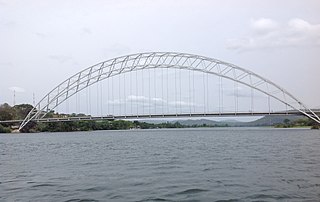
The Adomi Bridge is a latticed steel arch suspension bridge crossing the Volta River at Atimpoku in Ghana in West Africa. It is the first permanent bridge to span the Volta River, which drains south into the Gulf of Guinea, and is Ghana's longest suspension bridge. It provides the main road passage, just south of the Akosombo Dam, between the Eastern Region and the Volta Region of Ghana. It was opened in 1957 by Kwame Nkrumah, Ghana's first president. The iconic crescent-shaped arch bridge is featured in Ghanaian stamps and currency.
Boso is a small town in Asuogyaman District of the Eastern Region of Ghana, across from the Volta Lake.
Akosombo International School (AIS) is a Ghanaian coeducational international second-cycle institution located at Akosombo in the Asuogyaman District of the Eastern Region. It is operated by the Volta River Authority.
Senchi is a town in the Asuogyaman District of the Eastern Region of Ghana.
The N2 or National Highway 2 is a national highway in Ghana that begins at the Tema Motorway interchange at Tema and runs through Hohoe, Nkwanta, Yendi, and Bawku to the border with Burkina Faso at Kulungugu. It is the main north-south highway in the eastern corridor of the country, with a total distance of 640 kilometres (400 mi). The route runs through the Greater Accra, Eastern, Volta, Oti, Northern, North East Region and Upper East regions of Ghana.

Kaoga District is a former district council that was located in Eastern Region, Ghana. Originally created as an ordinary district assembly in 1975. However on 10 March 1989, it was split off into three new district assemblies: Yilo Krobo District, Manya Krobo District and Asuogyaman District. The district assembly was located in the eastern part of Eastern Region and had Somanya as its capital town.
The Kaleo Power Station is a 13 MW (17,000 hp) solar power plant in Ghana. The solar farm is owned and was developed by the Volta River Authority, between February 2020 and August 2022. The power off-taker is GRIDCo, which integrates the electricity into the national grid.


